Situation Summary
Samoa remains a low-threat environment with a composite threat score of 14 and no verified reports of armed conflict, civil unrest, major crime spikes, or critical infrastructure disruption in the last 24–48 hours. Three tracked events (a physical assault on 10 June, a public statement on 12 June, and an arrest on 12 June) have been logged but do not indicate systemic instability. The threat trajectory is stable; routine governance and development activities are proceeding without security incidents.
Key Developments
- Upolu & Savai'i, 10–12 June 2026 – Government of Samoa completed two days of consultations on the "Pathway for the Development of Samoa 2026/27–2030/31" national development framework. Community outreach continued on Savai'i with no reports of protests, unrest, or security incidents.
- Samoa-wide, 10 June 2026 – One physical assault incident recorded; no corroborated details on severity, location, or outcome are available in open sources.
- Samoa-wide, 12 June 2026 – One public statement and one arrest/detention event logged; specifics remain unconfirmed in available open web and social media.
- Broader Assessment – No verified incidents of gang violence, organized crime, maritime piracy, border incursions, or terrorism-related activity in the last 48 hours.
Highest-Risk Areas
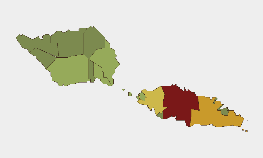
Tuamasaga (Upolu's capital district, risk score 85) and Ātua (risk 71) account for the majority of tracked risk in the country, reflecting higher population density, urban crime prevalence, and governance activity concentration. Aʻana (risk 62) and Aiga-i-le-Tai (risk 55) show moderate elevation, while the outer islands and rural districts (Vaʻa-o-Fonoti, Vaisigano, Gagaʻifomauga) register substantially lower composite scores. Risk clustering in the two largest urban and administrative centers is typical for small island states and does not indicate acute instability; rather, it reflects reporting concentration and routine criminal activity in populated areas.
How GeoBit Would Assist
Security teams should employ AOI (Area-of-Interest) Monitoring & Early Warning with persistent watch on Tuamasaga and Ātua to detect any escalation in arrest frequency, protest activity, or infrastructure disruption in near real time. Intel Sweep and multi-language OSINT (including X/Twitter, local media, and government channels) will enable rapid corroboration of emerging incidents and clarification of the three outstanding 10–12 June events. Network & Actor Analysis can map relationships among arrested or detained individuals to assess whether isolated incidents reflect organized activity or remain dispersed.
7-Day Outlook
No material change in threat posture is anticipated over the next seven days. The government development roadmap consultations are scheduled to continue as planned, and absent new reports of violence or unrest, the incident signals from 10–12 June are likely isolated. Duty-of-care teams should maintain standard baseline security protocols and rely on persistent monitoring to flag any shift toward elevated risk in Tuamasaga or Ātua.
Highest-Risk Areas — Ranked
| # | State / Region | Risk |
|---|---|---|
| 1 | Tuamasaga | 85 |
| 2 | Ātua | 71 |
| 3 | Aʻana | 62 |
| 4 | Aiga-i-le-Tai | 55 |
| 5 | Faʻasaleleaga | 48 |
| 6 | Palauli | 42 |
| 7 | Satupaʻitea | 38 |
| 8 | Gagaʻemauga | 35 |
| 9 | Gagaʻifomauga | 32 |
| 10 | Vaisigano | 28 |
| 11 | Vaʻa-o-Fonoti | 23 |
Sources
Previous Daily Briefs
A new Samoa brief is written every day — each with its own risk map and downloadable CSV. Here's the last week; use the calendar to go further back.
📅 Browse every day by calendar →
Highlighted days have a brief. Tap a day for that day's map & analysis, or “csv” for that day's dataset ($5).