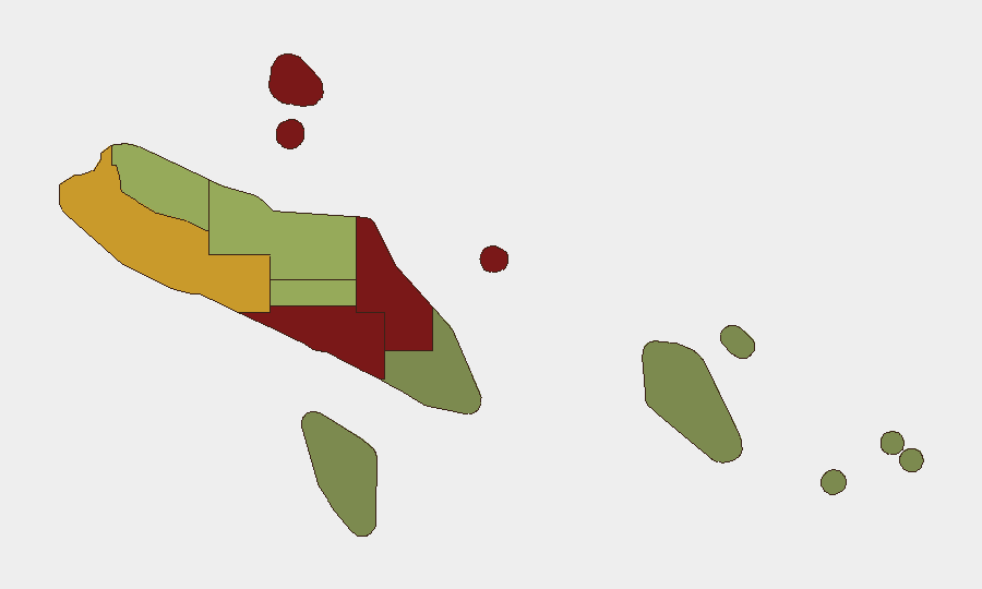
Situation Summary
Solomon Islands remains a low-intensity, chronic-risk environment with no acute security incidents, civil unrest, or infrastructure disruption reported in the last 24–48 hours. Risk is concentrated in urban centers—particularly Honiara and Guadalcanal—where routine gang activity, robbery, and interpersonal violence persist as baseline threats. The national security posture is stable; transport infrastructure and government operations are functioning normally without emergency restrictions or curfews.
Key Developments
- Honiara & Guadalcanal Province (13–15 June 2026) – No new security incidents or civil unrest reported; the security environment remains characterized by routine urban crime rather than organized violence or conflict escalation.
- Parliament House, Honiara (13–15 June 2026) – The Royal Solomon Islands Police Force has implemented heightened but routine security operations around current parliamentary sittings and an upcoming motion. This reflects planned precautionary measures aligned with parliamentary business, not a response to specific threats or unrest.
- Malango seismic zone, Guadalcanal (13 June 2026) – A magnitude 4.7 earthquake occurred approximately 132 km northwest of Malango. No damage, tsunami warning, or secondary security or infrastructure impacts were reported, and no follow-on disruptions have emerged in the subsequent 24–48 hours.
- Honiara International Airport & national seaports (13–15 June 2026) – All major transport nodes are operating normally without curfews, emergency restrictions, or reported security-related disruption.
- Nationwide governance (13–15 June 2026) – No states of emergency, nationwide curfews, or major administrative disruption are currently in force, and no new such measures have been announced.
Highest-Risk Areas
Honiara (risk score 92) and Guadalcanal Province (88) dominate the sub-national threat landscape, driven primarily by concentrated urban crime—gang rivalry, robbery, and interpersonal violence—rather than political instability or organized conflict. Malaita (85) and Western Province (72) follow, reflecting similar patterns of urban and localized criminal activity. These four provinces account for the majority of recorded security incidents nationwide; risk in the remaining provinces drops significantly, with Temotu and Rennell & Bellona (scores 18–22) representing minimal documented threat activity. Corporate and humanitarian assets concentrated in Honiara and surrounding Guadalcanal settlements face the highest baseline exposure to street crime and require standard urban security protocols.
How GeoBit Would Assist
Teams with personnel or assets in Solomon Islands should employ AOI Monitoring & Early Warning on Honiara, Guadalcanal, and Malaita to detect emerging civil unrest, protest activity, or security-force escalation in real time. Intel Sweep and OSINT fusion (X, Telegram, local media, radio SIGINT) provide continuous awareness of gang activity, port disruptions, and government policy shifts affecting curfews or movement restrictions. Routing & Network Analysis enables security teams to identify and pre-position alternative travel routes, seaport access, and evacuation pathways in case of localized unrest or infrastructure disruption.
7-Day Outlook
No acute security events or political triggers are anticipated over the next seven days. The security environment is expected to remain stable, with baseline urban crime continuing in Honiara and Guadalcanal. Parliamentary sittings and routine police operations should proceed without major disruption; monitor RSIPF announcements and parliamentary outcomes for any policy changes affecting business continuity or travel restrictions.
Highest-Risk Areas — Ranked
| # | State / Region | Risk |
|---|---|---|
| 1 | Honiara | 92 |
| 2 | Guadalcanal | 88 |
| 3 | Malaita | 85 |
| 4 | Western | 72 |
| 5 | Choiseul | 58 |
| 6 | Isabel | 52 |
| 7 | Central Province | 48 |
| 8 | Makira-Ulawa | 38 |
| 9 | Rennell and Bellona | 22 |
| 10 | Temotu | 18 |
Sources
Previous Daily Briefs
A new Solomon Islands brief is written every day — each with its own risk map and downloadable CSV. Here's the last week; use the calendar to go further back.
📅 Browse every day by calendar →
Highlighted days have a brief. Tap a day for that day's map & analysis, or “csv” for that day's dataset ($5).