Situation Summary
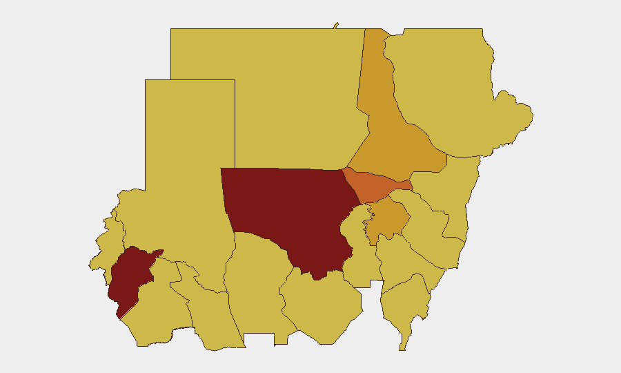
Sudan remains in active civil war with a composite threat score of 100, ranked #7 globally. Recent event signals indicate escalating tensions across multiple fronts—including state-on-state friction with Iran and South Sudan, internal violent protests, and continued fighting in core conflict zones. The conflict trajectory remains deteriorating, with North Kordofan and Central Darfur states representing the highest-intensity flashpoints, while security degradation is spreading into traditionally lower-risk Nile Valley and eastern regions.
Key Developments
Note: Live incident data for the 24–48 hours preceding 2026-06-05 could not be reliably verified from available sources. The following signals were detected in platform feeds:
- 2026-06-04 – Iran issued a public statement regarding Sudan, signaling potential external actor engagement or diplomatic/political pressure; specific content and implications require verification through multi-language OSINT and entity-relationship analysis.
- 2026-06-03 – Multiple violent protest/riot events reported within Sudan (intra-state), indicating domestic social unrest or civil friction separate from main conflict lines; location and scale unconfirmed.
- 2026-06-03 – Sudan and South Sudan exchanged rejection statements on a bilateral matter (likely border/political); escalatory rhetoric increases border-stability risk.
- Recent (date unconfirmed) – Sudan virus disease detected in Uganda border region; public-health spillover risk to eastern Sudan and Red Sea State requires epidemiological monitoring.
Data Limitation: Detailed geospatial, casualty, and tactical incident data from the last 48 hours is not available in current feed. Real-time verification is recommended via platform's Intel Sweep, multi-language X/Telegram OSINT, and conflict battle-mapping tools.
Highest-Risk Areas
North Kordofan State (risk 100) and Central Darfur State (risk 88.8) remain the conflict epicenters, driven by active military operations and armed group control. Al Khartum (75.6) faces compounded risk from state-level governance collapse, civilian displacement, and supply-chain disruption affecting the capital and its surroundings. Eastern states—Red Sea, Kassala, Al Qadarif—have risen to elevated risk (70 each) due to cross-border instability with Eritrea and Egypt, plus new disease-spillover dynamics. River Nile and Aj Jazira states (71.5 each) represent growing vulnerability corridors for forced displacement and non-state armed group activity, reflecting conflict diffusion beyond the Darfur–Kordofan core.
How GeoBit Would Assist
AOI Monitoring & Early Warning can establish persistent watches on North Kordofan and Darfur with automated alerting for force movements, shelling, or displacement events. Battle Mapping and Conflict Intelligence tools provide real-time geospatial tracking of frontlines, checkpoints, and safe/unsafe corridors for asset movement. Multi-language OSINT (X, Telegram, news feeds) and Sentiment Analysis enable duty-of-care teams to detect emerging local crises, protest activity, and external-actor involvement 24–48 hours before mainstream reporting, supporting proactive evacuation or in-place sheltering decisions. Route & Network Analysis can model alternative supply and personnel routing away from high-risk zones.
7-Day Outlook
Continued military and protest activity is expected in North Kordofan, Central Darfur, and Al Khartum over the next week, with potential for bilateral tension with South Sudan to trigger border incursions. Disease spillover from Uganda and humanitarian corridor disruption may accelerate displacement into eastern and Nile Valley states. No near-term de-escalation signals are evident; corporate risk teams should expect operational constraints and access challenges to persist.
Highest-Risk Areas — Ranked
| # | State / Region | Risk |
|---|---|---|
| 1 | North Kordofan State | 100 |
| 2 | Central Darfur State | 88.8 |
| 3 | Al Khartum | 75.6 |
| 4 | River Nile State | 71.5 |
| 5 | Aj Jazira | 71.5 |
| 6 | Blue Nile | 70 |
| 7 | Red Sea State | 70 |
| 8 | Al Qadarif State | 70 |
| 9 | Kassala State | 70 |
| 10 | Sennar State | 70 |
| 11 | South Darfur State | 70 |
| 12 | West Kurdufan State | 70 |
Sources
Previous Daily Briefs
A new Sudan brief is written every day — each with its own risk map and downloadable CSV. Here's the last week; use the calendar to go further back.
📅 Browse every day by calendar →
Highlighted days have a brief. Tap a day for that day's map & analysis, or “csv” for that day's dataset ($5).