Situation Summary
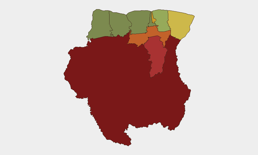
Suriname remains a lower-tier global security concern (composite threat score 2) with limited tracked events in the past 24 hours. However, sub-national risk is heavily concentrated in the interior and eastern districts, particularly Sipaliwini (risk 92) and Brokopondo (risk 78), where remote geography, limited state presence, and transnational criminal activity create persistent vulnerability. The capital region (Paramaribo, risk 71) and coastal belt present moderate risk. No significant security incident has been verified in the past 24–48 hours; a public statement event flagged on 2026-06-18 requires clarification from local sources to determine relevance to corporate operations.
Key Developments
- 2026-06-18 · Public Statement event flagged (source: GEOBIT EVENT SIGNALS) — nature, issuer, and operational impact require verification via local government, media, and embassy channels; no corroborating web research available at time of brief.
- No verified security, crime, civil unrest, or infrastructure incidents reported in Suriname over the past 24–48 hours from cross-referenced local and regional news sources.
- Interior districts remain operationally opaque — Sipaliwini and Brokopondo lack reliable real-time reporting infrastructure, increasing risk of undetected criminal or smuggling activity affecting supply chains and personnel movement.
- Coastal stability persists — Coronie and Nickerie (risk 8–12) continue to show low incident rates; routine crime and commercial activity dominate the risk profile in these zones.
Highest-Risk Areas
Sipaliwini and Brokopondo drive the majority of Suriname's tracked risk due to geographic isolation, weak state capacity, and prevalence of transnational smuggling (narcotics, gold, timber) and irregular armed group movement. Paramaribo, despite being the capital, ranks 4th due to urban crime, theft, and occasional gang activity concentrated in specific neighborhoods. The eastern border with French Guiana (Marowijne District, risk 68) remains a crossing point for irregular migration and contraband. Corporate teams with operations in the interior or eastern regions face higher exposure to supply-chain disruption, personnel security risk, and limited emergency response.
How GeoBit Would Assist
Teams with personnel or assets in Suriname should employ AOI Monitoring & Early Warning on high-risk districts (Sipaliwini, Brokopondo, Marowijne) to detect emerging incidents in real time, coupled with multi-language OSINT (X/Twitter, local news, government notices) to close the 24–48-hour reporting gap in remote zones. Routing & Network Analysis can identify secure alternative supply and personnel movement corridors to and from the interior and coastal zones, while entity extraction and sentiment analysis on regional and diaspora social media can flag early signs of civil unrest or policy shifts affecting operations. GIS & Spatial Analysis can map incident concentration and correlate it with corporate footprints.
7-Day Outlook
No immediate security escalation is anticipated over the next seven days. Monitoring should remain focused on interior districts and Paramaribo neighborhoods with known crime concentration. Duty-of-care teams are advised to refresh local liaison contacts and verify the 2026-06-18 public statement event through embassy and government channels to assess any downstream policy or regulatory impact on corporate activity.
Highest-Risk Areas — Ranked
| # | State / Region | Risk |
|---|---|---|
| 1 | Sipaliwini | 92 |
| 2 | Brokopondo | 78 |
| 3 | Para | 74 |
| 4 | Paramaribo | 71 |
| 5 | Marowijne | 68 |
| 6 | Commewijne | 42 |
| 7 | Wanica | 38 |
| 8 | Saramacca | 29 |
| 9 | Coronie | 12 |
| 10 | Nickerie | 8 |
Sources
Previous Daily Briefs
A new Suriname brief is written every day — each with its own risk map and downloadable CSV. Here's the last week; use the calendar to go further back.
📅 Browse every day by calendar →
Highlighted days have a brief. Tap a day for that day's map & analysis, or “csv” for that day's dataset ($5).