Situation Summary
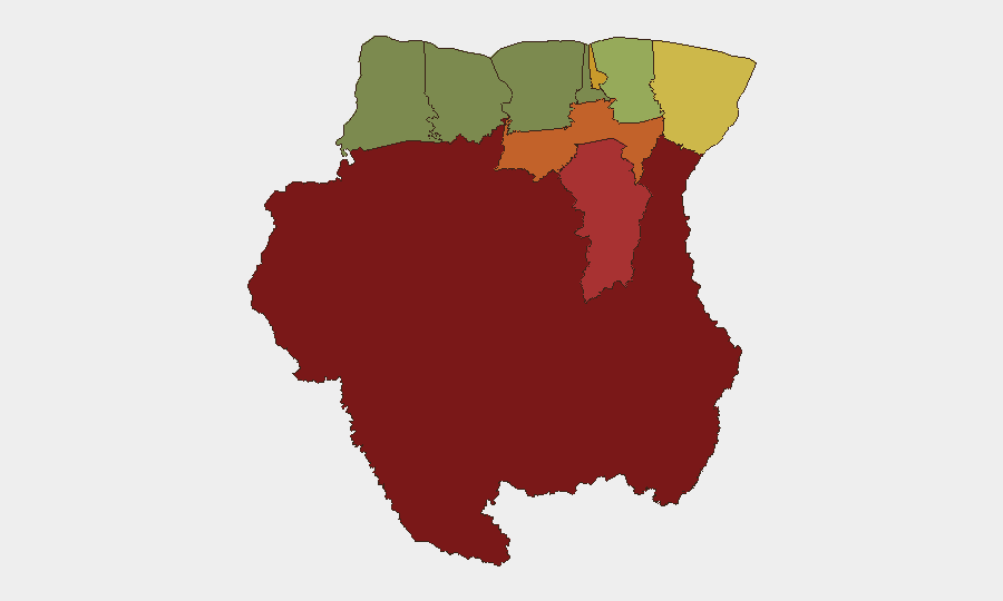
Suriname remains a low-intensity threat environment globally (rank #143, composite score 4), with no reliably confirmed acute security incidents, civil unrest, or infrastructure disruptions reported in the last 24–48 hours from credible open sources. The country's security picture is regionally differentiated, with interior and eastern districts (Sipaliwini, Brokopondo, Para) carrying substantially higher risk profiles than coastal zones. Near-term trajectory is stable, though baseline vulnerabilities in remote border areas and cross-border dynamics warrant continuous monitoring.
Key Developments
No major acute incidents confirmed in the last 24–48 hours. Open-web research identified no credible, multi-source reports of terrorist activity, large-scale crime, protests, or infrastructure failures within Suriname during 13–14 June 2026. Recent open coverage has focused on international capacity-building (e.g., OPCW chemical-safety engagement with Suriname's health ministry) and regional business/energy topics, not on active security threats. GeoBit event signals indicate background tensions involving activism, insurgent-group messaging, and cross-border friction (particularly Nigeria-related incidents), but these do not translate to confirmed current-day public-security impacts on the ground in Suriname requiring immediate duty-of-care escalation.
Highest-Risk Areas
Interior and eastern districts drive the national risk profile. Sipaliwini (risk 92) and Brokopondo (risk 78)—both sparsely populated, jungle-dominated areas with limited state presence—remain the highest-risk zones, primarily due to remote location, transnational narcotics transit, and limited law-enforcement reach. Para (74) and Paramaribo (71) follow, with the capital's elevated score reflecting urban crime, gang activity, and political/economic tensions, while Para reflects remote interior dynamics. Coastal and western districts (Commewijne, Wanica, Saramacca, Coronie, Nickerie) show substantially lower composite risk, indicating that threats are concentrated in geography with weaker institutional oversight and higher permeability to cross-border activity.
How GeoBit Would Assist
Security teams with personnel or assets in Suriname should prioritize Area-of-Interest Monitoring & Early Warning on Sipaliwini and Brokopondo to detect cross-border trafficking, informal armed activity, or supply-chain disruption in real time. Intel Sweep, global event feeds, and multi-language OSINT (including X/Twitter, Telegram, and local radio) provide continuous baseline tracking of activist statements, insurgent-group signaling, and Nigeria-linked incidents, enabling teams to distinguish noise from actionable escalation. Routing & Network Analysis and GIS & Spatial Analysis support alternative journey planning and asset-location risk assessment, especially for operations in or transiting high-risk interior districts.
7-Day Outlook
No acute flash-point or imminent disruption is anticipated over the next seven days based on current signals and open reporting. However, persistent background tensions involving cross-border actors and insurgent-group activity should be monitored continuously; any escalation in Nigeria-linked events or uptick in Sipaliwini/Brokopondo reporting would warrant rapid reassessment. Teams should maintain standard duty-of-care protocols and sustain real-time monitoring feeds, particularly for personnel operating outside Paramaribo or in transit corridors.
Highest-Risk Areas — Ranked
| # | State / Region | Risk |
|---|---|---|
| 1 | Sipaliwini | 92 |
| 2 | Brokopondo | 78 |
| 3 | Para | 74 |
| 4 | Paramaribo | 71 |
| 5 | Marowijne | 68 |
| 6 | Commewijne | 42 |
| 7 | Wanica | 38 |
| 8 | Saramacca | 29 |
| 9 | Coronie | 12 |
| 10 | Nickerie | 8 |
Sources
Previous Daily Briefs
A new Suriname brief is written every day — each with its own risk map and downloadable CSV. Here's the last week; use the calendar to go further back.
📅 Browse every day by calendar →
Highlighted days have a brief. Tap a day for that day's map & analysis, or “csv” for that day's dataset ($5).