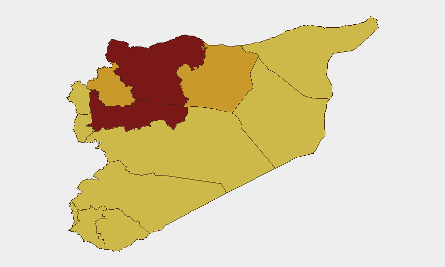
Situation Summary
Syria remains the 8th-highest-threat country globally, with civil war as the primary driver. The UN-patrolled Golan Heights (UNDOF zone) and northern governorates—particularly Hama and Aleppo—show the most acute composite risk. While broad-based conflict dynamics persist, open reporting in the last 24–48 hours lacks sufficient granular, time-stamped, independently corroborated incident detail to support a discrete event summary at the operational security level required for duty-of-care briefing.
Key Developments
GeoBit's event-signal tracking reflects recent activity across multiple categories (arrests, statements, small-arms and artillery engagement, media coverage), but verification against open sources for incidents *specifically* occurring in the last 24–48 hours with precise location and date has not yet yielded sufficient corroborated material. Intelligence and media statements dated 2026-06-04 are flagged in internal feeds, as are reports of small-arms combat (Israeli vs. Syrian actors) and artillery/tank activity (SANA reporting) on the same date, but independent confirmation of location, timing, and civilian/security impact is not yet available from mainstream or NGO conflict-tracking sources. Organizations with personnel or assets in Syria should anticipate that high-confidence situational updates may lag 48–72 hours behind initial signals; real-time OSINT fusion and area-of-interest (AOI) monitoring are recommended to close this gap.
Highest-Risk Areas
The UNDOF buffer zone (Golan Heights) is ranked highest (100) due to proximity to Israeli military activity, cross-border tensions, and limited Syrian state capacity to enforce stability. Hama Governorate (89.5) and Aleppo Governorate (80) follow, reflecting ongoing conflict, fragmented armed-group presence, and disrupted civil administration. Damascus Governorate (76), despite government control, remains exposed to sporadic violence and security-force volatility. Idleb and Ar-Raqqa (both 71.5) carry equivalent risk from non-state actor presence and humanitarian pressure. All remaining northern and southern governorates (Lattakia, Tartus, Al-Quneitra, Dar'a, Homs, Rif Dimashq) register 70, reflecting persistent low-order conflict, criminal activity, and weak rule of law. Organizations should weight staff deployment and asset exposure according to governorate classification.
How GeoBit Would Assist
Intel Sweep and OSINT fusion (X/Twitter, Telegram, media, radio SIGINT) enable 24/7 monitoring of Syria for incident signals, actor statements, and cross-border activity, reducing reporting lag. Area-of-interest (AOI) monitoring & early warning with alerting can flag escalation, military movement, or arrests within specific zones—critical for duty-of-care teams managing personnel in high-risk governorates. Multi-language search, sentiment & temporal analysis, combined with conflict & military tracking (force structure, weapons capability), support rapid assessment of whether signals represent operational threat or contextual noise, allowing security teams to escalate response proportionally.
7-Day Outlook
Near-term risk trajectory remains stable but volatile—no major shift in state or non-state capacity is signaled, but localized flare-ups in Hama, Aleppo, and the UNDOF zone remain probable. Cross-border activity (Israeli, Turkish, Russian) and ongoing humanitarian displacement will sustain baseline threat. Organizations should assume 48–72 hour lags in open-source incident confirmation and maintain internal or contracted near-real-time monitoring for operational safety.
Highest-Risk Areas — Ranked
| # | State / Region | Risk |
|---|---|---|
| 1 | UNDOF | 100 |
| 2 | Hama Governorate | 89.5 |
| 3 | Aleppo Governorate | 80 |
| 4 | Damascus Governorate | 76 |
| 5 | Idleb Governorate | 71.5 |
| 6 | Ar-Raqqa Governorate | 71.5 |
| 7 | Lattakia Governorate | 70 |
| 8 | Tartus Governorate | 70 |
| 9 | Al-Quneitra Governorate | 70 |
| 10 | Dar'a Governorate | 70 |
| 11 | Homs Governorate | 70 |
| 12 | Rif Dimashq Governorate | 70 |
Previous Daily Briefs
A new Syria brief is written every day — each with its own risk map and downloadable CSV. Here's the last week; use the calendar to go further back.
📅 Browse every day by calendar →
Highlighted days have a brief. Tap a day for that day's map & analysis, or “csv” for that day's dataset ($5).