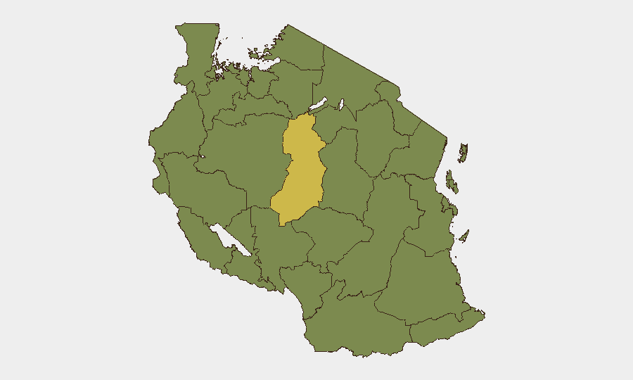
Situation Summary
Tanzania remains a moderate-risk operating environment (global rank #48) with 551 tracked security events and a composite threat score of 48. The country faces endemic crime, sporadic civil unrest, and localized terrorism concerns, particularly in Dar es-Salaam and border regions. Recent event signals include political statements, arrest activity, and multiple wildfire incidents; the security posture has stabilized following mid-July Saba Saba demonstrations but retains elevated baseline tension, especially around transport corridors and urban centers.
Key Developments
- 2026-07-19 · Political Statement Activity. Multiple public statements registered across Dar es-Salaam and national-level actors; context and specific impact not yet fully clarified in available reporting.
- 2026-07-19 · Regional Diplomatic Signal. Dar es-Salaam–Egyptian statement event recorded; suggests interstate or regional messaging with potential implications for border security and maritime activity.
- 2026-07-17 · Arrest/Detention Activity. National-level arrest or detention event logged; details on jurisdiction, scale, or political/criminal classification pending corroboration.
- Recent · Wildfire Cluster. Multiple wildfire events (IDs 1029426, 1029268, 1029303, 1029269, 1029182, 1029157, 1029217) active in recent days; geographic distribution and impact on critical infrastructure or transport routes under analysis.
Note: Available reporting does not permit attribution of a discrete, verified security incident in the last 24 hours. Standard warnings for demonstrations, transport disruption, telecom outages, and robbery/kidnapping remain in effect nationwide, with elevated concern in Dar es-Salaam and Mtwara Region.
Highest-Risk Areas
Singida Region (63.3) stands as the country's highest-risk sub-national zone, significantly exceeding the national composite score. Dar es-Salaam (38.3) remains the second-highest-risk urban center, reflecting persistent terrorism and civil-unrest concerns. A broad tier of northern and western regions—including Kigoma, Kagera, Mwanza, Geita, Shinyanga, Tabora, Katavi, Rukwa, Songwe, and Mara—register at 33.3 risk each, suggesting either shared border-security vulnerabilities, natural-resource competition, or cross-border criminal activity. Companies and personnel should prioritize security protocols in Singida and Dar es-Salaam and exercise heightened awareness on routes transiting the Lake Victoria basin and western border zones.
How GeoBit Would Assist
Intel Sweep and OSINT fusion would consolidate political statements, arrest filings, and regional diplomatic signals into a coherent risk narrative, identifying actors and intent. AOI Monitoring with persistent alerting on Singida Region, Dar es-Salaam, and border crossings would provide real-time warning of demonstrations, roadblocks, or telecom disruptions affecting duty-of-care compliance. Routing & Network Analysis would generate alternative journey plans that avoid high-risk corridors and identify safe havens or checkpoint locations, while Conflict & Actor Mapping would track arrest patterns and political tensions to forecast civil-unrest windows.
7-Day Outlook
Security conditions are expected to remain broadly stable over the next seven days, with baseline crime and transport risks persisting. Wildfire activity may disrupt logistics in affected regions; monitor regional power and supply-chain impacts. Watch for renewed political activity around commemorative dates or international announcements; any escalation in arrest patterns or regional statements would signal rising tension and warrant immediate situational reassessment.
Highest-Risk Areas — Ranked
| # | State / Region | Risk |
|---|---|---|
| 1 | Singida Region | 63.3 |
| 2 | Dar es-Salaam | 38.3 |
| 3 | Kigoma Region | 33.3 |
| 4 | Kagera | 33.3 |
| 5 | Mwanza Region | 33.3 |
| 6 | Geita | 33.3 |
| 7 | Shinyanga Region | 33.3 |
| 8 | Tabora Region | 33.3 |
| 9 | Katavi Region | 33.3 |
| 10 | Rukwa Region | 33.3 |
| 11 | Songwe Region | 33.3 |
| 12 | Mara Region | 33.3 |
Sources
Previous Daily Briefs
A new Tanzania brief is written every day — each with its own risk map and downloadable CSV. Here's the last week; use the calendar to go further back.
📅 Browse every day by calendar →
Highlighted days have a brief. Tap a day for that day's map & analysis, or “csv” for that day's dataset ($5).
Atlas — our AI intelligence desk — emails them this snapshot personally. Nothing else, no list.