Situation Summary
Trinidad and Tobago remains under a sustained State of Emergency amid persistent gang-related violence and armed crime concentrated in a small number of urban hotspots. The national threat composite score of 6 (global rank #120) reflects moderate but contained risk; however, sub-national variance is acute, with San Juan-Laventille (risk 95) and Port of Spain (risk 88) representing significantly higher exposure than most of the country. Government security posture is being reinforced through police funding, establishment of specialized units, and continued emergency protocols, though police leadership has publicly acknowledged resource constraints and a substantial equipment debt.
Key Developments
- National — 11 Jun 2026 — Homeland Security Minister Roger Alexander stated the Trinidad and Tobago Police Service faces a TT$500 million equipment debt and underfunding that constrains operational capacity, signaling resource-constrained response to crime.
- National — 11 Jun 2026 — Government reaffirmed that the State of Emergency will remain in place, maintaining elevated security posture and police powers across active enforcement zones.
- National — 11–12 Jun 2026 — The Trinidad and Tobago Police Service launched a new Diplomatic Security Unit, a specialized operational measure reflecting institutionalization of security response.
- National — 11–12 Jun 2026 — Government announced supplemental funding allocation of TT$5 million for the Police Service to support 27 divisions, addressing immediate capacity gaps.
- Tobago Division — 11–12 Jun 2026 — Local media reported the Tobago Division is experiencing mixed results in crime-fighting efforts on the island, indicating variability in operational effectiveness across jurisdictions.
- National — 12 Jun 2026 — Office of the Prime Minister scheduled a media conference on national security issues, signaling ongoing policy development and public communication on the security environment.
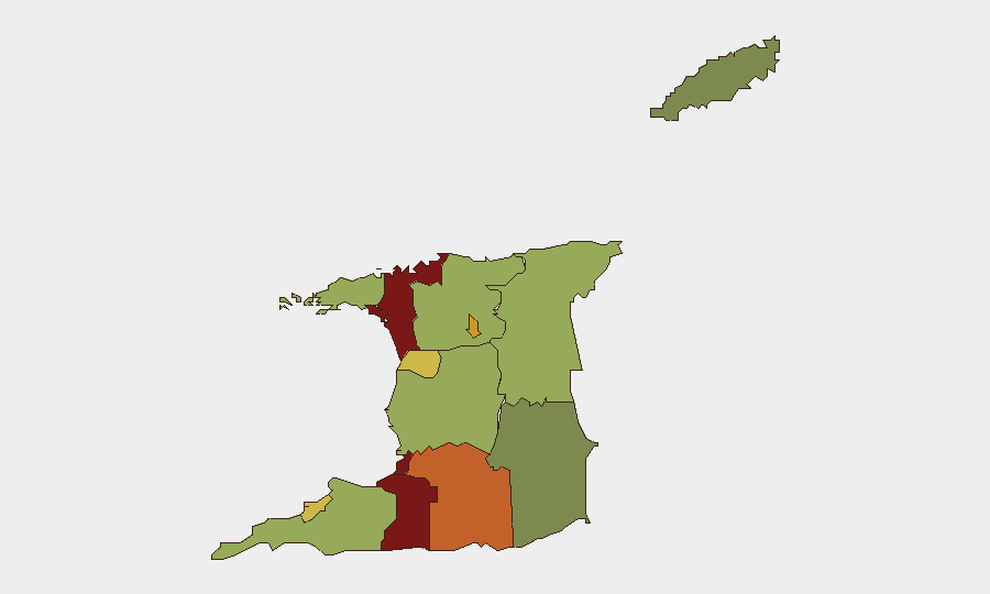
Highest-Risk Areas
San Juan-Laventille and Port of Spain dominate the risk profile, jointly accounting for the bulk of armed violence and gang-related crime. Both zones are characterized by entrenched criminal networks, gang territorial disputes, and recurring small-arms incidents; they should be treated as persistent high-consequence areas for any personnel or asset deployment. Secondary elevated-risk zones (Penal-Debe, San Fernando, Princes Town) form a band across central and southern Trinidad, while most rural and southern Tobago regions remain substantially lower-risk. This geographic concentration allows for targeted security planning but also means that operations in the capital region and western industrial corridor carry materially higher probability of exposure to armed violence.
How GeoBit Would Assist
Security teams would employ Intel Sweep and X/Telegram OSINT to detect emerging gang activity, leadership changes, or territorial disputes in high-risk zones before escalation. AOI Monitoring & Early Warning with persistent geospatial watch on San Juan-Laventille, Port of Spain, and secondary hotspots would provide real-time alerting if incident frequency or lethality shifts. Network & Actor Analysis and entity extraction would map criminal hierarchies and supply chains, enabling intelligence support for duty-of-care assessments and route-planning around known conflict zones.
7-Day Outlook
The State of Emergency and police resource augmentation are expected to remain in place through at least mid-June pending further cabinet review. Absent major incident escalation or political shift, violence levels in high-risk zones will likely remain elevated but not catastrophic; however, localized flare-ups in gang territorial disputes are common during funding announcements and policy transitions. Personnel and asset movements in San Juan-Laventille, Port of Spain, and the Penal-Debe corridor should be contingent on real-time threat intelligence and route diversification.
Highest-Risk Areas — Ranked
| # | State / Region | Risk |
|---|---|---|
| 1 | San Juan-Laventille | 95 |
| 2 | Port of Spain | 88 |
| 3 | Penal-Debe | 82 |
| 4 | San Fernando | 80 |
| 5 | Princes Town | 75 |
| 6 | Arima | 72 |
| 7 | Chaguanas | 68 |
| 8 | Point Fortin | 65 |
| 9 | Diego Martin | 58 |
| 10 | Siparia | 55 |
| 11 | Couva-Tabaquite-Talparo | 52 |
| 12 | Sangre Grande | 48 |
Sources
Previous Daily Briefs
A new Trinidad and Tobago brief is written every day — each with its own risk map and downloadable CSV. Here's the last week; use the calendar to go further back.
📅 Browse every day by calendar →
Highlighted days have a brief. Tap a day for that day's map & analysis, or “csv” for that day's dataset ($5).