סיכום המצב
טרינידד וטובגו נותרת סביבה בעלת סיכון בינוני (דירוג עולמי #114) עם פעילות פשע וכנופיות מתמשכת המרוכזת במסדרונות עירוניים ותעשייתיים. הצהרת חירום נשארת בתוקף, עם פעולות אכיפה מתמשכות. לא אושרה עלייה משמעותית ב-24–48 השעות האחרונות ממקורות זמינים, אם כי חיכוך מוסדי והשפעתי הכרוך בתובע הכללי והפרלמנט צץ בהצהרות ציבוריות וצעדים פרלמנטריים. יציבות הביטחון נותרת יציבה אך שביר, כאשר אלימות מקומית ופעילות משלוח ימי ממשיכים כדפוסי בסיס.
התפתחויות עיקריות
הערה: חקר רשת לייב שנערך בעת הדוח לא הניב כשלים נפרדים בעלי חתימת זמן של אירועי ביטחון מ-17–18 ביוני 2026 שיכלו להיות מאומתים ומיוחסים בביטחון תפעולי. דיווח אחרון בתחום הציבור מתייחס ל:
- מתיחות בין תובע כללי ופרלמנט (16–18 ביוני): הצהרות ציבוריות מרובות והשלכות חקיקתיות הכרוכות בתובע הכללי וחקיקים, כולל הצביעות אי-אישור וצעדי דרישה. חיכוך מוסדי עלול לסבך את תיאום אכיפת החוק.
- ניהול הצהרת חירום (יוני מתמשך): אילוצי חוב בכושר התפעול של TTPS נשארים חשש מבני; 698 אנשים הואשמו לפי הוראות SoE עד אמצע יוני. אין סימן לתרגיל עתידי של סמכויות חירום.
- פעילות משלוח ימי (חלון תאריך לא מאומת): שומרי החוף דיווחו על יירוט של כלי שיט עם 20 עצורים; אימות וחתימת זמן מדויקת לא אומתו באופן עצמאי במקורות זמינים.
צוותי אבטחה קורפוטיביים מועצים להשלים דוח זה בסינון בזמן אמת של CNC3, Guardian Media, Loop TT, חשבונות TTPS רשמיים, וייעוצי שגרירות ארה"ב בפורט אוף ספיין עבור אירועים עם חתימות זמן גלויות ב-24 השעות האחרונות.
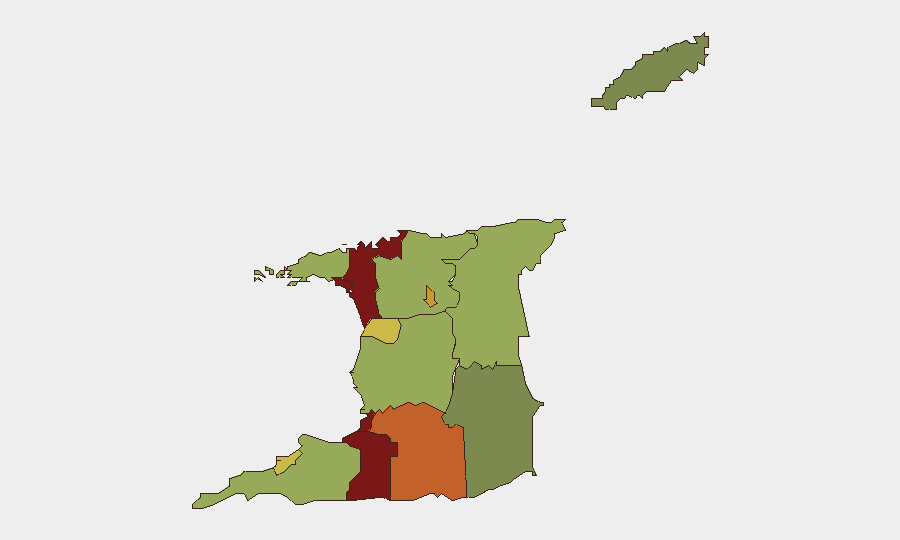
אזורים בסיכון הגבוה ביותר
סן חואן-לוונטיל (סיכון 95) וport of Spain (סיכון 88) נשארים מוקדי העיר החריפים, מונעים על ידי נוכחות כנופיות, הפצת סמים, והשוד. Penal-Debe (82) וסן פרננדו (80) בדרום מייצגים מסדרונות משניים של דאגה המקושרים לרשתות סחר ופשע מאורגן. ארבע אזורים אלה מהווים את רוב הפשע הרציני ודורשים מודעות עובדים מוגברת וחיזוק נכסים. סיכון יורד משמעותית מעבר לשכבה העליונה, אם כי Princes Town (75) ו-Arima (72) מצדיקים מעקב מתמשך.
כיצד GeoBit יסייע
צוותי אבטחה צריכים לפרוס ניטור AOI (אזור עניין) והתרעה מוקדמת על חמשת אזורי הסיכון המובילים לקבלת התרעות על פעילות הפגנה, אינדיקטורים של פעילות כנופיות, והצטברות אירועים בזמן אמת. היתוך OSINT על פני מדיה מקומית, הזנות מדיה משפטיות, וערוצי Telegram יעלו מודיעין ברמת אירוע מהר יותר מאשר צבירת חדשות כללית. ניתוח רשת ושחקן יכול למפות זיקות כנופיות ודרכי סחר לתמיכה בתכנון מסלול הפחתת סיכון שרשרת אספקה לפעולות בסן חואן-לוונטיל, Port of Spain, אזורים תעשייתיים.
תחזוקה של 7 ימים
בהיעדר התפרקות פוליטית גדולה או הסלמה במשבר מוסדי, נצפה שתנאי הביטחון יישארו ברמות בסיס הנוכחיות עד סוף יוני. החיכוך בין תובע כללי לפרלמנט מצדיק ניטור לאותות של פיצול אכיפת חוק או שינויי מדיניות המשפיעים על פעולות נגד פשע. מנהלי עובדים ונכסים צריכים לשמור על עירנות מוגברת בחמשת אזורי הסיכון המובילים ולהקים פרוטוקולי תקשורת מאובטחים במהלך כל הרחבה של הצהרת חירום או התפתחויות משפטיות/פרלמנטריות גדולות.
האזורים בסיכון הגבוה ביותר — מדורגים
| # | מדינה / אזור | סיכון |
|---|---|---|
| 1 | San Juan-Laventille | 95 |
| 2 | Port of Spain | 88 |
| 3 | Penal-Debe | 82 |
| 4 | San Fernando | 80 |
| 5 | Princes Town | 75 |
| 6 | Arima | 72 |
| 7 | Chaguanas | 68 |
| 8 | Point Fortin | 65 |
| 9 | Diego Martin | 58 |
| 10 | Siparia | 55 |
| 11 | Couva-Tabaquite-Talparo | 52 |
| 12 | Sangre Grande | 48 |
מקורות
תדריכים יומיים קודמים
תדריך חדש על Trinidad and Tobago מתפרסם מדי יום — לכל אחד מפת סיכונים משלו ו-CSV להורדה. זהו השבוע האחרון; השתמשו בלוח השנה כדי לחזור אחורה.
📅 Browse every day by calendar →
Highlighted days have a brief. Tap a day for that day's map & analysis, or “csv” for that day's dataset ($5).