Situation Summary
Trinidad and Tobago remains at moderate overall threat level (rank #62 globally), with persistent gang violence, police counter-operations, and targeted crime concentrated in Port of Spain and surrounding districts. Recent days have seen intensified law-enforcement activity—including counter-trafficking raids and gang-crime operations under state-of-emergency provisions—alongside isolated incidents of arson targeting a journalist and armed confrontations in residential areas. The security environment is characterized by localized but recurring violence rather than systemic instability, though enforcement operations and gang activity create friction points for residents and business operations in high-risk zones.
Key Developments
- Lowlands, Tobago – 25 July 2026 – A TV6 Tobago journalist's vehicle was deliberately set on fire outside her home around 2 a.m.; the occupants extinguished the blaze before total loss. Police opened an arson investigation. *Significance: Targeted attack on media worker, potential intimidation, ongoing criminal inquiry.*
- Port of Spain & Morvant, Trinidad – 24–25 July 2026 – Following a shooting outside a Morvant resident's home, TTPS North Eastern Division increased mobile patrols and roadblocks in the districts and stated they are intensifying operations (patrols, house searches, Preventive Detention Orders) in response to recent gang-related killings under the current state of emergency. *Significance: Renewed gang activity, heightened police presence and checkpoint activity affecting movement.*
- Curepe, Trinidad – late July 2026 (reported within 48h) – TTPS conducted an intelligence-led operation targeting suspects linked to a home invasion; officers encountered an armed suspect who pointed a firearm at them, and police responded with lethal force. The suspect died. *Significance: Armed crime in populated area, indicates active property-crime enforcement.*
- Nationwide, Trinidad & Tobago – 25 July 2026 – Counter Trafficking Unit led *Operation Iceberg*, executing three Preventive Detention Orders against suspects in a human-trafficking network across multiple locations. The multi-agency operation concluded its second phase. *Significance: Heightened enforcement activity, possible follow-on raids and checks.*
- Nationwide – 23–24 July 2026 – Homeland Security Minister revoked Preventive Detention Orders for businessman Dominic Hadeed and his wife, leading to their release after nearly one month in custody over an alleged plot to assassinate the Prime Minister and senior officials. Authorities stated the criminal investigation remains active. *Significance: High-profile political-security case ongoing; protective measures for officials likely continue.*
Highest-Risk Areas
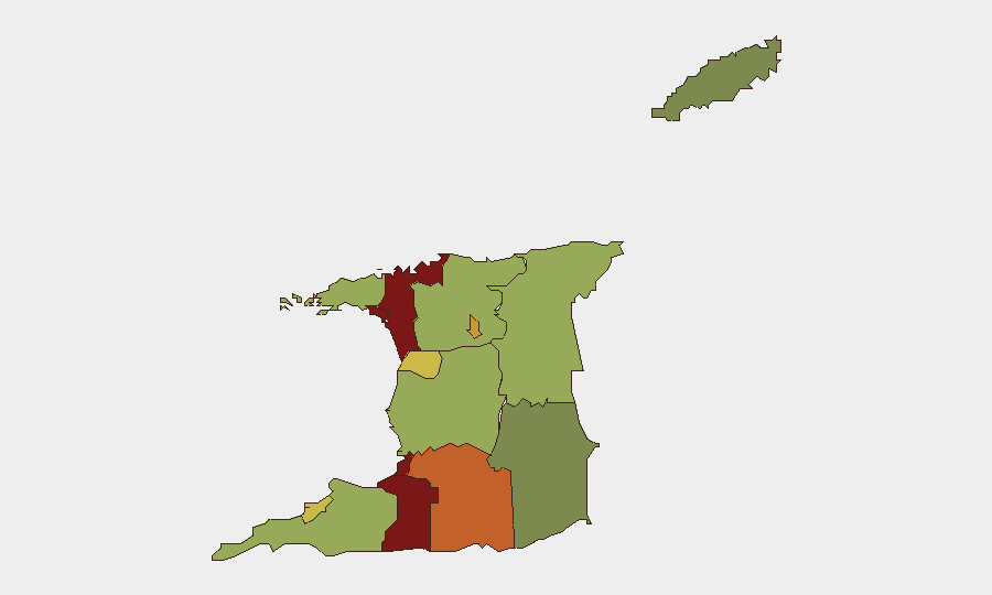
San Juan-Laventille (risk 95) and Port of Spain (risk 88) dominate the threat landscape, driven by gang-territorial violence, drug-related crime, and police counter-operations under state-of-emergency provisions. Penal-Debe, San Fernando, and Princes Town (risks 82, 80, 75 respectively) form a secondary cluster of concern in southern Trinidad. Recent developments—the Morvant shooting, intensified Morvant–Laventille patrols, and the Curepe armed confrontation—confirm that north-east Port of Spain and adjacent neighborhoods remain the primary flashpoints for both gang activity and law-enforcement response.
How GeoBit Would Assist
Security teams operating in Trinidad and Tobago should employ AOI Monitoring & Early Warning to track developments in San Juan-Laventille and Port of Spain districts, combined with Intel Sweep (X/Twitter & Telegram OSINT, open-source event feeds) to capture emerging incidents and police operations in real time. Routing & Network Analysis enables identification of safer movement corridors during periods of heightened checkpoint activity and gang presence, while Risk & Threat Assessment and Entity Extraction support continuous monitoring of law-enforcement posture and criminal-actor activity.
7-Day Outlook
Gang violence and police counter-operations are expected to persist in Port of Spain and Morvant through early August, with checkpoint and search activity likely to remain elevated under the state-of-emergency framework. The arson attack on the journalist and the ongoing assassination-plot investigation suggest potential for further targeted incidents; corporate teams should maintain heightened situational awareness for staff in high-risk areas and adjust movement protocols accordingly.
Highest-Risk Areas — Ranked
| # | State / Region | Risk |
|---|---|---|
| 1 | San Juan-Laventille | 95 |
| 2 | Port of Spain | 88 |
| 3 | Penal-Debe | 82 |
| 4 | San Fernando | 80 |
| 5 | Princes Town | 75 |
| 6 | Arima | 72 |
| 7 | Chaguanas | 68 |
| 8 | Point Fortin | 65 |
| 9 | Diego Martin | 58 |
| 10 | Siparia | 55 |
| 11 | Couva-Tabaquite-Talparo | 52 |
| 12 | Sangre Grande | 48 |
Sources
Previous Daily Briefs
A new Trinidad and Tobago brief is written every day — each with its own risk map and downloadable CSV. Here's the last week; use the calendar to go further back.
📅 Browse every day by calendar →
Highlighted days have a brief. Tap a day for that day's map & analysis, or “csv” for that day's dataset ($5).
Atlas — our AI intelligence desk — emails them this snapshot personally. Nothing else, no list.