Situation Summary
Yemen remains a complex, multi-layered conflict environment with 13 active tracked events and a composite threat score of 95.1, placing it among the 12 highest-risk countries globally. The civil war between Houthi forces (controlling the northwest, including the capital Sana'a) and the internationally recognized government (based in Aden) continues to drive insecurity, while Red Sea maritime attacks, Israeli and US-led airstrikes, humanitarian collapse, and criminal networks create overlapping risk vectors. The situation shows no immediate de-escalation signals; recent large-scale military strikes and Houthi detention of UN personnel suggest the conflict is consolidating into entrenched regional and international dimensions.
Key Developments
- Sana'a (Houthi-controlled) – Houthi authorities have intensified arbitrary detention and seizure of UN and aid-worker assets and premises, drawing UN and international rights condemnation and signaling elevated political and detention risk for internationals operating in northern areas.
- Red Sea / Bab al-Mandab corridor – Houthi forces maintained attacks and rocket fire on commercial shipping and Israeli targets; Human Rights Watch assessment of potential war crimes underscores sustained maritime security risk for vessels transiting Yemen's west coast.
- Aden (interim capital) – US State Department reiterated evacuation guidance, citing heightened regional military tensions and limited commercial flight access as the sole functioning international exit point, elevating travel bottleneck and stranding risk.
- Hodeidah port (west coast) – Recent Israeli airstrikes damaged the main port and airport infrastructure, killing at least three and degrading the critical humanitarian aid entry point; port security and cargo logistics risks remain acute.
- Sana'a and 12 nationwide Houthi sites – US and UK forces conducted large-scale airstrikes on 36+ Houthi targets, including underground weapons depots and air-defense systems; elevated retaliation risk and potential for civilian harm in strike zones.
- Southern and eastern governorates (Hadramout, Shabwa, Lahj, Al-Mahra, Abyan) – IED attacks on military vehicles, Houthi-frontline clashes, drone incidents, and large Captagon/medicine seizures signal persistent insurgent, roadside-bomb, and organized-crime risk along inland and coastal supply routes.
- Nationwide humanitarian crisis – Over 18 million people require assistance amid economic collapse; displacement, resource competition, and criminality elevate baseline security risk across most governorates.
- UN-Houthi standoff – Ongoing "unlawful seizure" of UN premises and arbitrary detention of UN personnel constrains humanitarian operations and raises specific risk for NGOs, UN contractors, and local implementing partners in Houthi areas.
Highest-Risk Areas
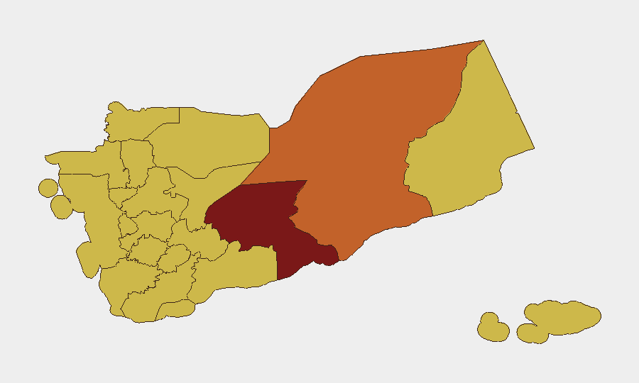
Shabwah Governorate (96.6) stands as the single most acute risk zone, driven by contested territory, IED activity, and criminal smuggling networks. The second-tier cluster—Hadramaut (74.1) and a band of northwestern governorates (Sa'dah, Hajjah, Al Hudaydah, 'Amran, and Sana'a at 66.6 each)—reflects Houthi control, airstrikes, detention risk, and frontline volatility. These rankings reflect conflict intensity, humanitarian need, and the intersection of military operations, criminality, and political repression rather than uniform geographic threat.
How GeoBit Would Assist
Security teams should employ AOI (Area-of-Interest) Monitoring & Early Warning to track Sana'a detention patterns, Aden airfield status, and Hodeidah port infrastructure in real time. Conflict & Military capabilities (battle mapping, force-structure tracking) and Routing & Network Analysis enable identification of safe transit corridors and evacuation alternatives in southern and eastern zones. OSINT Fusion (X, Telegram, local media, event feeds) combined with Sentiment & Temporal Analysis will surface emerging detention, strike, or maritime-attack signals 12–48 hours before escalation.
7-Day Outlook
Near-term risk remains static to elevated. Houthi detention of internationals and ongoing airstrikes on Sana'a suggest no immediate softening of political or military posture. Aden's dependence on limited commercial aviation creates acute evacuation bottleneck risk; any airport closure or escalation in Red Sea attacks would trigger mass-evacuation demand on an already-constrained corridor.
Highest-Risk Areas — Ranked
| # | State / Region | Risk |
|---|---|---|
| 1 | Shabwah Governorate | 96.6 |
| 2 | Hadramaut Governorate | 74.1 |
| 3 | Sa'dah Governorate | 66.6 |
| 4 | Hajjah Governorate | 66.6 |
| 5 | Al Mahwit Governorate | 66.6 |
| 6 | Al Hudaydah Governorate | 66.6 |
| 7 | 'Amran Governorate | 66.6 |
| 8 | Amanat Al Asimah | 66.6 |
| 9 | Sana'a Governorate | 66.6 |
| 10 | Raymah Governorate | 66.6 |
| 11 | Dhamar Governorate | 66.6 |
| 12 | Ibb Governorate | 66.6 |
Previous Daily Briefs
A new Yemen brief is written every day — each with its own risk map and downloadable CSV. Here's the last week; use the calendar to go further back.
📅 Browse every day by calendar →
Highlighted days have a brief. Tap a day for that day's map & analysis, or “csv” for that day's dataset ($5).