Résumé de la Situation
Les Comores présentent un environnement de sécurité de base à modéré sans incident aigu confirmé signalé au cours des 24 à 48 dernières heures. L'archipel reste caractérisé par des vulnérabilités structurelles de longue date—fragmentation politique, faiblesse de la capacité de l'État et exposition au trafic maritime—concentrées à Anjouan et Grande Comore. Aucune escalade actuelle ou événement déclencheur discret n'est apparent dans les rapports en sources ouvertes disponibles au 22 juillet 2026.
Développements Clés
Aucun incident confirmé de manière indépendante et crédible en matière de sécurité, de conflit, de troubles civils, de criminalité, d'instabilité politique, d'infrastructure ou de risque de voyage n'a été signalé aux Comores au cours des 24 à 48 dernières heures selon la surveillance systématique en sources ouvertes (actualités, réseaux sociaux, alertes maritimes et flux régionaux). Ceci représente une absence de signal plutôt qu'une absence d'incident ; des événements locaux mineurs peuvent survenir sans large couverture médiatique. Les équipes de sécurité d'entreprise et de devoir de diligence doivent traiter cette période comme stable sauf information contraire de sources premium ou en territoire.
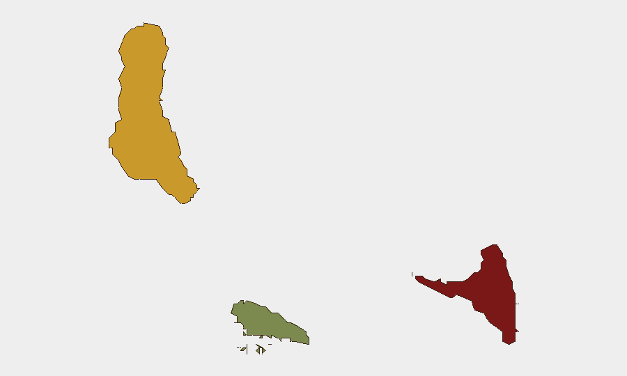
Zones à Risque Maximal
Anjouan (score de risque 88) et Grande Comore (score de risque 72) déterminent le profil de menace de l'archipel et justifient la concentration des ressources de protection. Anjouan connaît historiquement la plus forte concentration de dysfonctionnement administratif, de groupes armés informels, d'activités de trafic et de tensions politiques entre îles ; Grande Comore, où siège la capitale Moroni, concentre la population, l'activité économique et les vulnérabilités de gouvernance. Moheli (score de risque 35) reste substantiellement à risque plus faible. Le personnel corporatif, les lignes d'approvisionnement et les infrastructures critiques doivent appliquer des protocoles de vigilance renforcés à Anjouan et dans le centre de Moroni ; Moheli permet des restrictions opérationnelles allégées.
Comment GeoBit Pourrait Assister
Balayage Intel & Fusion OSINT fournirait une surveillance continue multilingue et multi-plateforme des actualités comorienne, des réseaux sociaux et des signaux de trafic maritime pour détecter les indicateurs précoces d'instabilité politique, de troubles localisés ou de perturbation portuaire/maritime avant qu'ils n'affectent les opérations. Surveillance AOI Persistante & Alerte Précoce sur Anjouan et Moroni déclencherait des alertes en temps réel si des incidents discrets (troubles civils, activité des forces de sécurité, dommages aux infrastructures) émergeaient, permettant une réponse rapide du devoir de diligence. Analyse d'Acheminement & de Réseau et Suivi Maritime soutiendraient la planification des contingences pour l'évacuation du personnel et le réacheminement de la chaîne d'approvisionnement en cas de dégradation des conditions.
Perspectives à 7 Jours
Aucune escalade imminente n'est signalée par les rapports actuels. Cependant, la fragilité sous-jacente des Comores—différends administratifs entre îles, activités maritimes informelles et capacité d'État limitée—signifie que des incidents localisés peuvent émerger avec un préavis limité. Les équipes de sécurité doivent maintenir une posture de vigilance de base, confirmer leur réseau de renseignement en territoire et leurs procédures d'évacuation, et programmer un examen de réappréciation des menaces de 48 à 72 heures si tout incident discret surgissait à Anjouan ou Moroni.
PROCHAIN BRIEFING PLANIFIÉ : 23 juillet 2026, 06:00 UTC
CYCLE DE SURVEILLANCE RECOMMANDÉ : Quotidien (Anjouan/Grande Comore) ; 48 à 72 heures (Moheli)
DÉCLENCHEURS D'ESCALADE : Affrontements armés, annonce politique affectant les relations entre îles, fermeture portuaire, incident maritime dans la ZEE comorienne.
Zones les Plus à Risque — Classées
| # | État / Région | Risque |
|---|---|---|
| 1 | Anjouan | 88 |
| 2 | Grande Comore | 72 |
| 3 | Moheli | 35 |
Sources
Bulletins Quotidiens Précédents
Un nouveau bulletin Comoros est publié chaque jour — chacun avec sa carte de risque et son CSV téléchargeable. Voici la dernière semaine ; utilisez le calendrier pour remonter plus loin.
📅 Browse every day by calendar →
Highlighted days have a brief. Tap a day for that day's map & analysis, or “csv” for that day's dataset ($5).
Atlas — our AI intelligence desk — emails them this snapshot personally. Nothing else, no list.