Situation Summary
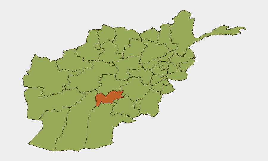
Afghanistan remains in acute multidimensional crisis, ranking #30 globally on GeoBit's composite threat index (63.3) with insurgency as the primary driver. A catastrophic Pakistani airstrike on a Kabul drug rehabilitation centre killing approximately 400 civilians, combined with a 6.3-magnitude earthquake in northern Afghanistan and concurrent internet restrictions, has sharply elevated humanitarian and security risk across the country. The UN describes the environment as a "perfect storm" of overlapping crises—active terrorist presence (IS-K, al-Qaeda, ETIM, TTP, BLA), cross-border hostilities, economic collapse, and governance restrictions—with no near-term de-escalation trajectory visible.
Key Developments
- Kabul, Kabul Province – Mass-casualty Pakistani airstrike (2026-06-03): Pakistani military strike on a rehabilitation centre killed at least 400 people overnight; UN has condemned the strike and called for permanent end to cross-border hostilities and civilian protection measures.
- Eastern & southern border regions – Escalating cross-border hostilities (ongoing): Pakistan-Afghanistan clashes are undermining stability, restricting civilian movement, and elevating risk for anyone transiting or working near cross-border zones; UN warning signals sustained threat intensity.
- Northern Afghanistan – 6.3-magnitude earthquake with mass displacement (2026-06-03): Initial reports confirm at least 20 dead and hundreds injured; UN teams deployed; infrastructure damage and displacement compounding existing humanitarian crisis and security fragmentation.
- Nationwide – Taliban-ordered internet blackout (2026-06-02 to ongoing): Internet restrictions imposed during earthquake response, disrupting humanitarian coordination, situational awareness, and access to remote communities; complicating duty-of-care operations for international organizations and corporate entities.
- Earthquake-affected eastern regions – Heightened vulnerability for women and girls: UN Women reports elevated exploitation and violence risk post-earthquake, particularly in areas under Taliban control with restricted freedoms and services.
- Nationwide – Waterborne disease outbreak risk (emerging): UNICEF warning of 212,000+ Afghan children at acute risk from watery diarrhoea and waterborne illness due to earthquake-damaged water infrastructure and service collapse.
- Nationwide humanitarian appeal (2026-06-02): UN launched $1.7 billion appeal to assist 18 million people in urgent need, reflecting chronic instability, economic breakdown, and Taliban governance constraints as persistent security multipliers.
Highest-Risk Areas
Uruzgan Province (74.3) dominates the risk ranking, driven by sustained Taliban insurgency activity and limited state presence. Maidan Wardak (49.0) and Nangarhar (46.5) follow, with Nangarhar's proximity to the Pakistan border and ISKP/IS-K operational footprint adding cross-border complexity. Kabul Province (44.9), despite central location and international presence, reflects political volatility, arrest/detention events, and recurring mass-casualty incidents (including the 2026-06-03 airstrike). Southern and eastern provinces (Kandahar, Ghazni, Paktika, Zabul) cluster at 44–46 risk, reflecting Taliban control, narcotics trafficking, and cross-border militant movement. The earthquake damage is likely to elevate northern provinces (Balkh at 45.1) in coming weeks as infrastructure collapse and displacement intensify.
How GeoBit Would Assist
Security teams should deploy AOI Monitoring & Early Warning on Uruzgan, Nangarhar, and Maidan Wardak to track insurgency activity and cross-border movement in near-real time. Intel Sweep (X/Twitter, Telegram OSINT, multi-language search) would enable continuous monitoring of Taliban announcements, internet restrictions, and humanitarian access disruptions affecting duty-of-care operations. Routing & Network Analysis would support alternative journey planning for personnel and supply movement, bypassing high-risk cross-border and earthquake-affected corridors. Conflict & Military mapping would clarify Taliban control zones, Pakistani military activity, and terrorist group positioning to inform risk assessment and evacuation planning.
7-Day Outlook
Earthquake aftershock risk, disease outbreak acceleration, and cascading humanitarian deterioration will likely sustain high volatility through mid-June. Cross-border hostilities are unlikely to cease without diplomatic intervention, keeping eastern and southern zones at elevated threat. Internet restrictions may persist, further constraining situational awareness and humanitarian response effectiveness for corporate and NGO stakeholders.
Highest-Risk Areas — Ranked
| # | State / Region | Risk |
|---|---|---|
| 1 | Uruzgan Province | 74.3 |
| 2 | Maidan Wardak Province | 49 |
| 3 | Nangarhar Province | 46.5 |
| 4 | Zabul Province | 45.8 |
| 5 | Balkh Province | 45.1 |
| 6 | Kabul Province | 44.9 |
| 7 | Helmand Province | 44.6 |
| 8 | Kandahar Province | 44.3 |
| 9 | Ghazni Province | 44.3 |
| 10 | Paktika Province | 44.3 |
| 11 | Farah Province | 44.3 |
| 12 | Nimruz Province | 44.3 |
Previous Daily Briefs
A new Afghanistan brief is written every day — each with its own risk map and downloadable CSV. Here's the last week; use the calendar to go further back.
📅 Browse every day by calendar →
Highlighted days have a brief. Tap a day for that day's map & analysis, or “csv” for that day's dataset ($5).