Situation Summary
Angola ranks #49 globally in composite threat (score 35) with no tracked security incidents recorded to date in 2026. Two small-arms combat events were signaled on 2026-06-21, though open-source reporting has not yet corroborated details of location, scale, or outcome. Concurrent wildfire activity across multiple provinces presents secondary infrastructure and humanitarian risk. The overall security environment remains stable relative to historical baselines, but activity in eastern border regions warrants continued monitoring.
Key Developments
- 2026-06-21 · Small Arms Combat · Angola – Two separate small-arms engagements reported; location and parties not yet confirmed in available open-source channels. Significance and casualty count unknown pending corroboration.
- Wildfire Activity (Recent) · Multiple Provinces – At least 11 discrete wildfire events detected across Angola and border areas with DRC (events 1028991, 1028906, 1028888, 1028920, 1028922, 1028964, 1028835, 1028857, 1028873, 1028892). Geographic spread and containment status require satellite-based damage assessment and provincial emergency-response data to evaluate impact on transportation, power, or populated centers.
Note: Web research (last 24 hours) has not returned credible, time-stamped open-source reporting on these incidents. Verification through specialized crisis-alert feeds, provincial government statements, and Angolan media outlets (Jornal de Angola, O País, Novo Jornal) is recommended in parallel.
Highest-Risk Areas
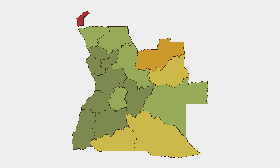
Cabinda Province (risk 78) remains Angola's single highest-threat zone, driven by long-standing separatist activity and cross-border trafficking dynamics; Lunda Norte (72) and Lunda Sul (68) follow, with elevated risk linked to artisanal and illicit diamond mining, transnational organized crime, and resource-competition violence. Cuando Cubango, Cunene, and Moxico provinces (64, 62, 58 respectively) form a volatile eastern frontier arc with Namibia and Zambia, characterized by porous borders, smuggling networks, and periodic armed group activity. Risk drops significantly below risk-50 threshold west of the interior plateau; Luanda and coastal provinces remain comparatively stable. Corporate and NGO operations in eastern provinces should prioritize field-level intelligence networks and contingency routing.
How GeoBit Would Assist
AOI Monitoring & Early Warning with persistent watch on Cabinda, Lunda Norte/Sul, and Cuando Cubango would deliver automated alerts on armed activity, population displacement, or infrastructure disruption before mainstream reporting. Satellite & Imagery Analysis can rapidly assess wildfire perimeters, road/rail damage, and humanitarian access bottlenecks across the current fire zones. Routing & Network Analysis enables real-time alternative journey planning for staff and supply movements, bypassing active threat areas and degraded infrastructure. Network & Actor Analysis maps trafficking and armed-group relationships in eastern provinces, improving contextual risk assessment for mining, energy, and logistics operations.
7-Day Outlook
The two small-arms events on 2026-06-21 do not yet indicate a significant escalation pattern, but confirmation of location and frequency over the next 48–72 hours will be critical to trajectory assessment. Wildfire activity is expected to persist into the dry season; secondary effects (smoke, road closures, power outages, displacement) may compound in interior and eastern zones. No major political, electoral, or ceremonial triggers are identified for the next week; routine baseline monitoring and field-level situational awareness remain the primary mitigation posture.
Highest-Risk Areas — Ranked
| # | State / Region | Risk |
|---|---|---|
| 1 | Cabinda Province | 78 |
| 2 | Lunda Norte Province | 72 |
| 3 | Lunda Sul Province | 68 |
| 4 | Cuando Cubango Province | 64 |
| 5 | Cunene Province | 62 |
| 6 | Moxico Province | 58 |
| 7 | Zaire Province | 54 |
| 8 | Huambo Province | 50 |
| 9 | Uíge Province | 48 |
| 10 | Malanje Province | 42 |
| 11 | Bié Province | 35 |
| 12 | Huíla Province | 32 |
Sources
Previous Daily Briefs
A new Angola brief is written every day — each with its own risk map and downloadable CSV. Here's the last week; use the calendar to go further back.
📅 Browse every day by calendar →
Highlighted days have a brief. Tap a day for that day's map & analysis, or “csv” for that day's dataset ($5).