Situation Summary
The Bahamas maintains a composite threat score of 32, placing it in the lower-to-moderate risk tier globally. The country's security environment is characterized by persistent localized crime and civil-order concerns concentrated in urban centers, particularly New Providence and Freeport, rather than systemic instability or active conflict. Recent event signals (18 June) indicate localized tensions involving military force and presidential disapproval, though open-source corroboration remains limited. No major deterioration in national security or travel conditions has been documented in the past 24–48 hours.
Key Developments
GeoBit's live web research has not identified discrete, corroborated security incidents meeting threshold criteria (specific location, date within 48 hours, multi-source verification) as of 20 June 2026. Recent indexed news, travel advisories, and social media monitoring show routine tourism and business activity with no new crime spike, civil unrest, or infrastructure failure documented in that window. The three flagged event signals from 18 June (military force involvement and presidential disapproval) require verification against official or credible news sources to confirm operational significance and exact locations. Ongoing routine crime concerns typical to Nassau and Freeport persist but lack a clearly dated acute trigger in the last two days. If additional context on these 18 June signals or a wider time window (5–7 days) is needed to support operational planning, GeoBit can provide expanded analysis.
Highest-Risk Areas
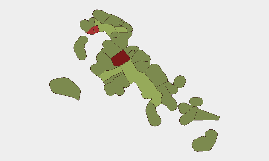
New Providence (risk 92) and the City of Freeport (risk 78) dominate the sub-national threat profile, accounting for the majority of tracked security events and crime concentration. Both are major commercial and residential hubs where interpersonal violence, property crime, and gang activity are endemic. Central Abaco (risk 52), Central Andros (risk 48), and Exuma (risk 45) show moderate elevation, reflecting dispersed localized concerns; the remaining outer islands and cays present lower discrete risk but remain subject to the same baseline crime and emergency-response constraints as the broader archipelago. Corporate assets and personnel should prioritize heightened awareness and contingency planning for New Providence and Freeport, with standard duty-of-care protocols applied across other populated centers.
How GeoBit Would Assist
Continuous AOI Monitoring & Early Warning on New Providence and Freeport, coupled with multi-language OSINT fusion (news, social media, official alerts, and radio SIGINT), enables real-time detection of acute crime spikes, civil disorder, or infrastructure disruptions affecting travel and operations. Entity extraction and sentiment & temporal analysis on X/Telegram and local news outlets identify emerging protest activity or political tension before wide dissemination. Routing & Network Analysis supports contingency-route planning for personnel and supply chains, while GIS & Spatial Analysis maps high-risk and lower-risk zones within affected districts for targeted duty-of-care deployment.
7-Day Outlook
The near-term trajectory shows no indicators of imminent national-level instability or travel disruption. Localized crime and order concerns in New Providence and Freeport will likely persist at baseline levels, with summer season potentially increasing foot traffic and routine incident frequency in tourism zones. Monitoring of the 18 June event signals and official government statements will clarify any latent political or institutional tensions over the coming week.
Highest-Risk Areas — Ranked
| # | State / Region | Risk |
|---|---|---|
| 1 | New Providence | 92 |
| 2 | City of Freeport | 78 |
| 3 | Central Abaco | 52 |
| 4 | Central Andros | 48 |
| 5 | Exuma | 45 |
| 6 | East Grand Bahama | 42 |
| 7 | South Andros | 38 |
| 8 | North Abaco | 35 |
| 9 | North Eleuthera | 33 |
| 10 | South Abaco | 32 |
| 11 | Cat Island | 30 |
| 12 | Mangrove Cay | 28 |
Sources
Previous Daily Briefs
A new Bahamas brief is written every day — each with its own risk map and downloadable CSV. Here's the last week; use the calendar to go further back.
📅 Browse every day by calendar →
Highlighted days have a brief. Tap a day for that day's map & analysis, or “csv” for that day's dataset ($5).