Situation Summary
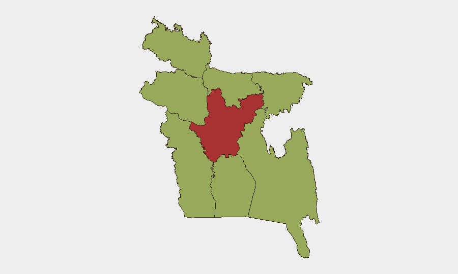
Bangladesh remains at composite threat rank #29 globally with 28 tracked security events; Dhaka Division significantly outpaces all other regions at risk score 77.2. A major India–Bangladesh border standoff has escalated over the past 48 hours, with BSF–BGB confrontations in the Cooch Behar–Lalmonirhat sector and multiple crossing points triggering defensive mobilization by Bangladesh Border Guard units and elevated diplomatic friction. Concurrent investigative actions, administrative sanctions, and arrests reported 10–11 June suggest domestic political tension alongside the border crisis. The combination of acute border stress, active law-enforcement activity, and health events (measles, Nipah) creates a compound risk environment requiring immediate situational clarity for organizations with personnel or assets in high-risk zones.
Key Developments
- Cooch Behar–Lalmonirhat border sector (India–Bangladesh), 10–11 June – BSF and BGB engaged in standoff over approximately 40 stranded Bangladeshi nationals at zero point; BGB accused India of attempted pushbacks; confrontations reported at Mekhliganj, Sitalkuchi, and Dinhata crossing points with both forces in elevated alert posture.
- BGB fortification & defensive deployment, western and northern Bangladesh border, last 48 hours – Reports indicate BGB has dug additional bunkers, trenches, machine-gun nests, mortar positions, observation posts, and APC placements along sensitive border stretches in response to deportation and incursion concerns.
- Border village mobilization, Bangladesh–West Bengal frontier, 10–11 June – Community-level night patrols, sandbag positions, and local volunteer groups established in villages opposite West Bengal; residents advised to avoid border-proximate fields due to fear of cross-border firing or arrest.
- Siliguri Corridor (Chicken's Neck) area, northern Bangladesh–India frontier, 10–11 June – Indian forces reported on reinforced posture following BSF directive for forceful response to fence tampering; Bangladeshi social commentary frames this as escalation affecting adjacent border districts.
- Meghalaya border sector, Bangladesh villages, 10–11 June – Local Bangladeshi residents and BGB conducting joint frontier monitoring; multiple social posts report ad-hoc observation posts and 24-hour watch groups established amid push-in incursion fears.
- Dhaka political and diplomatic level, 10–11 June – Government signaled plans to discuss border killings and pushbacks in upcoming bilateral talks while simultaneously highlighting BGB defensive preparations; reflects elevated diplomatic friction and internal political salience of border situation.
- Arrest and administrative action, 10 June – Reports of economist arrest by BANGLADESH authorities and citizen-vs-state administrative sanctions, concurrent with investigative actions; contextual indicator of domestic governance friction.
Highest-Risk Areas
Dhaka Division (77.2) dominates the risk landscape by a factor of 1.5× over all other regions, reflecting capital-concentration of political, administrative, and economic activity where investigative actions, arrests, and policy-level tensions crystallize. Northern border divisions—Rajshahi (50.6), Rangpur (47.2), and Sylhet (48.4)—face acute tactical risk from the India–Bangladesh border standoff, BGB mobilization, and community-level militarization. Chittagong and Barishal divisions remain at baseline elevated risk (47.2) typical of port and delta regions; Mymensingh and Khulna track similarly. Organizations with staff in Dhaka should assume heightened administrative and investigative scrutiny; those in northern border zones should monitor force posture, community checkpoints, and cross-border movement friction.
How GeoBit Would Assist
Organizations should deploy AOI Monitoring & Early Warning on Dhaka Division and the India–Bangladesh border corridor (Cooch Behar, Rangpur, Sylhet) to track BGB posture, community mobilization, and cross-border incident frequency in real time. OSINT fusion and corroboration across Telegram, X, YouTube, and Bengali-language news sources will provide early signal of escalation or de-escalation. GIS & Spatial Analysis combined with satellite imagery analysis would confirm fortification work and force concentrations reported in unstructured social data. Risk & Threat Assessment can model impact of border closure, administrative action, or health event spread on personnel movement and supply chains.
7-Day Outlook
The India–Bangladesh border standoff is likely to persist at elevated tension for 5–7 days pending bilateral diplomatic engagement; BGB defensive posture will remain elevated, and cross-border friction at secondary checkpoints should be expected. Domestic political and investigative activity in Dhaka will likely continue as government addresses internal governance concerns alongside external border pressure. Organizations should prepare contingency protocols for temporary border zone access restrictions and heightened scrutiny of movement in capital and northern districts.
Highest-Risk Areas — Ranked
| # | State / Region | Risk |
|---|---|---|
| 1 | Dhaka Division | 77.2 |
| 2 | Rajshahi Division | 50.6 |
| 3 | Sylhet Division | 48.4 |
| 4 | Khulna Division | 47.2 |
| 5 | Barishal Division | 47.2 |
| 6 | Chittagong Division | 47.2 |
| 7 | Rangpur Division | 47.2 |
| 8 | Mymensingh Division | 47.2 |
Sources
Previous Daily Briefs
A new Bangladesh brief is written every day — each with its own risk map and downloadable CSV. Here's the last week; use the calendar to go further back.
📅 Browse every day by calendar →
Highlighted days have a brief. Tap a day for that day's map & analysis, or “csv” for that day's dataset ($5).