Situation Summary
Barbados remains a low-threat, stable environment with no corroborated security incidents, civil unrest, or infrastructure disruptions reported in the last 24–48 hours. GeoBit's composite threat ranking places the nation at #79 globally (score 14), reflecting manageable risk levels typical of the Eastern Caribbean. Recent public statements flagged by the platform—spanning company–employee disputes, legislative matters, and diplomatic communications—have not escalated into verified incidents. The security posture is steady, with risk concentrated in urban parishes rather than systemic national instability.
Key Developments
- No corroborated security incidents have been confirmed in Barbados over the last 24–48 hours via open-source monitoring or multi-source corroboration. Recent platform signals refer to public statements and routine institutional developments rather than acute events.
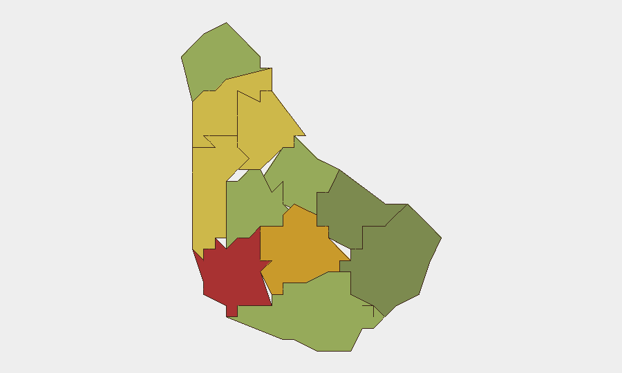
- Saint Michael (risk score 78) and Saint George (risk score 72) remain the highest-risk parishes, likely reflecting urban concentration, higher population density, and associated crime-baseline patterns typical of capital-region and coastal commercial zones.
- Recent flagged items—including a senator statement (2026-07-09) and diplomatic/lawmaker communications (2026-07-11)—lack independent corroboration and show no signs of operational escalation into security incidents.
- Routine institutional activity, including police leadership transitions, continues without associated security disruptions or unrest.
- No travel advisories, infrastructure failures, or humanitarian emergencies have emerged in the current reporting window.
- Regional events in Puerto Rico and other jurisdictions are being monitored but do not present direct spillover risk to Barbados at this time.
Highest-Risk Areas
Saint Michael and Saint George parishes drive the country's composite risk score, reflecting typical urban-crime and commercial-sector vulnerabilities concentrated in Bridgetown and surrounding zones. Saint James (risk 68) and Saint Andrew (risk 65) follow as secondary concern areas. The southern and eastern parishes—Saint Philip (28), Saint John (35), and Christ Church (42)—register substantially lower risk, suggesting risk is geographically clustered rather than distributed. Risk drivers appear rooted in population density, economic activity, and baseline criminal patterns rather than acute conflict or instability.
How GeoBit Would Assist
Corporate security teams with assets or personnel in Barbados should employ Intel Sweep and multi-language OSINT fusion to maintain persistent awareness of public statements, social media sentiment, and emerging unrest signals across the highest-risk parishes. AOI Monitoring with alerting on Saint Michael and Saint George—combined with Entity Extraction and Actor Analysis—enables early detection of organized crime or protest activity before operational impact. Risk & Threat Assessment and GIS & Spatial Analysis tools support duty-of-care mapping of assets by parish and scenario-based route planning to avoid high-risk zones if circumstances shift.
7-Day Outlook
No acute threat escalation is anticipated over the next seven days based on current baseline and absence of triggering incidents. Continued monitoring of public statements and legislative activity is prudent; however, the low probability of rapid deterioration supports normal business continuity planning. Security teams should maintain routine awareness of Saint Michael and Saint George developments and confirm staff evacuation protocols as a standard control rather than response to elevated risk.
Highest-Risk Areas — Ranked
| # | State / Region | Risk |
|---|---|---|
| 1 | Saint Michael | 78 |
| 2 | Saint George | 72 |
| 3 | Saint James | 68 |
| 4 | Saint Andrew | 65 |
| 5 | Saint Peter | 62 |
| 6 | Saint Joseph | 58 |
| 7 | Saint Thomas | 52 |
| 8 | Saint Lucy | 48 |
| 9 | Christ Church | 42 |
| 10 | Saint John | 35 |
| 11 | Saint Philip | 28 |
Sources
Previous Daily Briefs
A new Barbados brief is written every day — each with its own risk map and downloadable CSV. Here's the last week; use the calendar to go further back.
📅 Browse every day by calendar →
Highlighted days have a brief. Tap a day for that day's map & analysis, or “csv” for that day's dataset ($5).
Atlas — our AI intelligence desk — emails them this snapshot personally. Nothing else, no list.