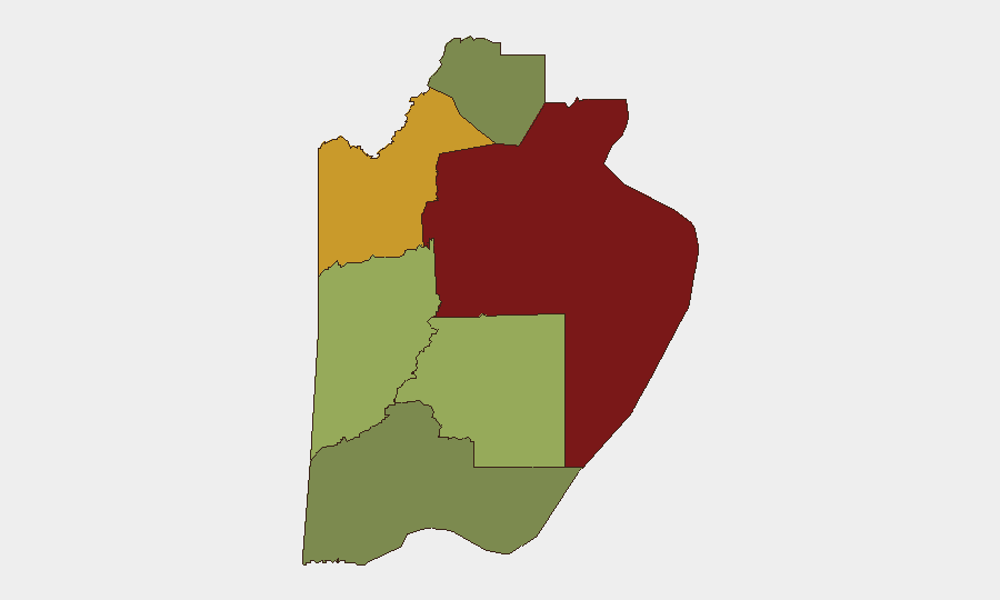
Situation Summary
Belize faces elevated but localized violent-crime risk, concentrated in Belize City and driven by gang activity and organized-crime pressure. A cluster of shooting incidents reported in Belize City on 24 June 2026—including a double homicide—signals a recent uptick in gang-related violence in the country's most populous urban center. The national composite threat score remains low (17), but sub-national disparities are acute: Belize District accounts for the overwhelming majority of tracked risk. The security trajectory is volatile in urban gang hotspots but stable across rural and northern districts.
Key Developments
- Belize City, Belize District — 24 June 2026: A double homicide was reported as part of a cluster of three shooting incidents within 24 hours, attributed to gang violence and under police investigation (News 5 Live).
- Belize City — 24 June 2026: Gang-linked violence escalation in the south side of Belize City remains the dominant risk driver; the incidents align with documented concentration of violent crime in that corridor.
- Nationwide — 23 June 2026: GeoBit's event feed logged a demand/investigation signal and physical-assault signal; open-source confirmation and precise location details remain unavailable, warranting internal follow-up.
- Nationwide — 22 June 2026: A threat event involving the Belize government and a suspected drug trafficker was recorded in the event feed; corroborating open-source reporting is not yet available.
- Corozal Town — date unconfirmed: Social media reports indicate partial loss of operational surveillance-camera infrastructure; temporal verification and independent confirmation are pending.
- Cayo District (Hummingbird Highway) — date unconfirmed: An unverified incident report involving a fatal traffic accident (21-year-old male) lacks independent corroboration and precise timeline; road safety context only.
*Note: No discrete events meeting full corroboration and temporal-precision standards were confirmed in the final 48 hours beyond the Belize City 24 June shooting cluster.*
Highest-Risk Areas
Belize District, particularly Belize City's south side, dominates the national risk profile (composite score 95) and accounts for gang-violence concentration, extortion networks, and organized-crime presence. Orange Walk District (score 72) ranks second and warrants monitoring for drug-trafficking corridor activity and cross-border instability spillover from Guatemala and Mexico. Cayo District (score 58) shows moderate risk, primarily linked to trafficking routes and property crime along major arteries. Southern and northern districts (Toledo, Stann Creek, Corozal) remain substantially lower-risk environments, though rural isolation and limited law-enforcement presence create pockets of vulnerability in each.
How GeoBit Would Assist
Security teams with personnel or assets in Belize should deploy AOI Monitoring & Early Warning on Belize City's south side and Orange Walk District to track clustering of gang violence, extortion incidents, and cartel activity in near-real-time. Intel Sweep and OSINT fusion across social media, local news feeds, and government law-enforcement signals will close reporting lags and corroborate rumors before they escalate to operational risk. Routing & Network Analysis should be applied to identify safe alternative corridors for staff movement, particularly between districts and around Belize City's high-risk zones.
7-Day Outlook
The 24 June shooting cluster suggests renewed competitive pressure among gangs or external drug-trafficking organization encroachment; such spikes typically persist for 5–14 days before stabilizing or escalating further. Expect continued elevated police activity and possible curfew or checkpoint deployment in Belize City. Routine travel and commercial activity should remain feasible outside Belize District and the south-side corridor, but duty-of-care protocols should remain heightened pending next week's incident trend.
Highest-Risk Areas — Ranked
| # | State / Region | Risk |
|---|---|---|
| 1 | Belize District | 95 |
| 2 | Orange Walk District | 72 |
| 3 | Cayo District | 58 |
| 4 | Stann Creek District | 48 |
| 5 | Toledo District | 35 |
| 6 | Corozal District | 22 |
Sources
Previous Daily Briefs
A new Belize brief is written every day — each with its own risk map and downloadable CSV. Here's the last week; use the calendar to go further back.
📅 Browse every day by calendar →
Highlighted days have a brief. Tap a day for that day's map & analysis, or “csv” for that day's dataset ($5).