Situation Summary
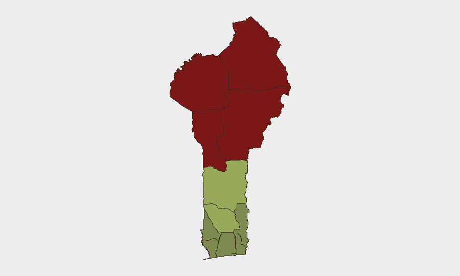
Benin remains at composite threat rank #57 globally with a moderate national threat score of 22, reflecting a complex but currently stable security environment. The northern border departments (Alibori, Atakora, Donga, Borgou) continue to face elevated risk from persistent cross-border militant activity and trafficking networks linked to Sahel-wide instability, while southern coastal regions maintain substantially lower threat profiles. No major security incidents or civil unrest have been reported in Benin itself in the last 24–48 hours; however, the immediate regional context—including confirmed armed activity in Niger on 18 June—underscores latent transnational pressure on Benin's northern frontier.
Key Developments
No credible, independently sourced security, conflict, civil-unrest, crime, political-instability, or infrastructure incidents meeting 24–48 hour verification standards have been identified in Benin during this reporting window. Regional security scans and open-source monitoring (19–20 June 2026) covering West Africa confirm activity in neighboring states but report no new confirmed events within Benin's borders. Government advisories and NGO/security-firm alerts remain unchanged. Routine political and economic commentary is circulating but does not indicate a shift in the national threat environment.
Highest-Risk Areas
The northern tier—Alibori (risk 92), Atakora (88), Donga (85), and Borgou (83)—accounts for the majority of Benin's composite threat. These departments face recurring cross-border infiltration, trafficking networks, and occasional militant activity connected to broader Sahel instability; Alibori and Atakora in particular sit astride porous frontiers with Niger and Burkina Faso. The central belt (Zou, Collines, Plateau) shows moderate residual risk, likely tied to localized crime and resource-competition tensions. Southern departments (Littoral, Ouémé, Atlantique, Mono) maintain substantially lower scores, reflecting more stable administrative control and economic activity; these remain suitable for routine business and diplomatic operations with standard precautions.
How GeoBit Would Assist
Corporate security teams with personnel or assets in Benin would deploy AOI Monitoring & Early Warning on the high-risk northern departments (Alibori, Atakora, Donga, Borgou) to detect cross-border incursions, trafficking movement, or militia activity before they escalate into regional incidents; paired with Intel Sweep and X/Twitter OSINT covering Sahel actor networks and regional militant claims, this combination provides tactical early notice. GIS & Spatial Analysis and Satellite & Imagery analysis support risk-mapping for specific project sites, supply-chain nodes, and personnel movement corridors, while Routing & Network Analysis identifies safer alternative routes away from border zones during periods of elevated activity. Conflict & Military tracking of force dispositions in neighboring Niger and Burkina Faso informs cross-border threat assessment without requiring boots-on-ground.
7-Day Outlook
Benin's security trajectory is expected to remain stable domestically over the next week, with no indicators of imminent civil unrest or major crime escalation. However, latent northern-border pressure from Sahel-wide militant networks and trafficking activity will persist; continued monitoring of Niger and Burkina Faso for spillover activity is warranted, particularly in Alibori and Atakora departments. Standard duty-of-care protocols (movement planning, site security, personnel briefing) remain appropriate; no broad travel restrictions or facility evacuations are indicated at present.
Highest-Risk Areas — Ranked
| # | State / Region | Risk |
|---|---|---|
| 1 | Alibori Department | 92 |
| 2 | Atakora Department | 88 |
| 3 | Donga Department | 85 |
| 4 | Borgou Department | 83 |
| 5 | Zou Department | 45 |
| 6 | Collines Department | 42 |
| 7 | Plateau Department | 38 |
| 8 | Kouffo Department | 35 |
| 9 | Mono Department | 32 |
| 10 | Atlantique Department | 28 |
| 11 | Littoral | 25 |
| 12 | Ouémé Department | 22 |
Sources
Previous Daily Briefs
A new Benin brief is written every day — each with its own risk map and downloadable CSV. Here's the last week; use the calendar to go further back.
📅 Browse every day by calendar →
Highlighted days have a brief. Tap a day for that day's map & analysis, or “csv” for that day's dataset ($5).