Situation Summary
Benin remains at moderate global risk (#51, composite score 37), with terrorism and insurgency as the primary threat drivers, though no major attacks were recorded in the past week. Security incidents in the reporting period were concentrated in common-crime categories (armed robbery, phone theft, cybercrime) and were geographically dispersed across the south and central regions. Northern border departments continue to present significantly elevated risk due to ongoing regional insurgency pressures, but the country's overall security posture remains stable absent new militant activity.
Key Developments
- Bantè, Collines Department (7–8 Oct): Police arrested three suspected armed robbers during a nighttime operation; officers seized a homemade firearm, two machetes, cannabis, and approximately CFA 503,000. Two alleged robbery victims provided statements.
- Dantokpa Market, Cotonou (7 Oct): Police arrested six suspects linked to a phone-theft and trafficking network involving over 800 stolen handsets. Thefts were concentrated in high-traffic commercial zones (Carrefour Lègba, Mahoulé, 4 Thérapies pharmacy).
- Matéri, Atacora Department (6–9 Oct, lower confidence): Police reportedly dismantled a cross-border motorcycle-theft and trafficking ring; specific arrest dates and secondary corroboration remain limited in available reporting.
- Tovigomé, Bohicon, Zou Department (6–8 Oct): Five family members were arrested on suspicion of cybercrime/online fraud following resident complaints.
- Djidja-Centre, Zou Department (6 Oct): Police rescued a child approximately 10 years old who had been beaten and held captive; circumstances remain unclear.
- Tchaourou, Borgou Department (6 Oct): A detainee suspected of theft was found dead at the central police station; cause of death was not established in available reporting.
- Ammunition Seizures (29–30 Sep): Police intercepted two separate caches of unregistered ammunition (3,250 and 1,975 cartridges respectively) in motorcycle-based operations and a wooded cache in Danmambou; multiple arrests were made.
- Cotonou (8 Oct): Benin and Germany conducted military cooperation and capacity-building talks; the agenda reflected stated security concerns in northern and eastern border areas but did not announce new incidents or emergency measures.
Highest-Risk Areas
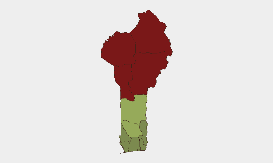
Alibori, Atakora, Donga, and Borgou departments in the north and northeast form a contiguous high-risk belt (scores 83–92), driven by cross-border insurgency movements and porous frontier controls shared with Niger and Burkina Faso. These regions experience recurring armed-group activity linked to regional Sahel-based militant networks; security force presence is comparatively limited. The south-central corridor (Zou, Collines, Plateau departments, scores 38–45) faces secondary risk primarily from organized crime and petty violence. Littoral, Ouémé, and Atlantique departments remain the lowest-risk zones, reflecting stronger state presence and lower criminal prevalence.
How GeoBit Would Assist
Security teams should deploy AOI Monitoring & Early Warning on northern department border crossings and known militant transit corridors to detect activity escalation before incidents occur. Multi-language OSINT and social-media intelligence (X, Telegram) enable continuous sentiment and actor-network tracking in Alibori and Atakora; Intel Sweep and event-feed fusion corroborate fragmentary police and media reports in real time. GIS & Spatial Analysis can map theft, robbery, and trafficking clusters (e.g., Dantokpa phone-theft network) to identify operational patterns and protect high-value supply chains or personnel movement.
7-Day Outlook
No imminent shift in the threat picture is signaled by current reporting. Petty crime and organized theft are likely to continue at baseline rates in urban commercial zones; northern border instability will remain persistent but is not expected to spike absent regional escalation in Niger or Burkina Faso. Monitoring of ammunition caches and weapons trafficking remains warranted given the continued seizures observed in late September and early October.
Highest-Risk Areas — Ranked
| # | State / Region | Risk |
|---|---|---|
| 1 | Alibori Department | 92 |
| 2 | Atakora Department | 88 |
| 3 | Donga Department | 85 |
| 4 | Borgou Department | 83 |
| 5 | Zou Department | 45 |
| 6 | Collines Department | 42 |
| 7 | Plateau Department | 38 |
| 8 | Kouffo Department | 35 |
| 9 | Mono Department | 32 |
| 10 | Atlantique Department | 28 |
| 11 | Littoral | 25 |
| 12 | Ouémé Department | 22 |
Sources
Previous Weekly Briefs
A new Benin brief is written every Monday, covering the week — each with its own risk map and downloadable CSV. Use the calendar to go further back.
- October 5, 2026
- September 28, 2026
- September 21, 2026
- September 14, 2026
- September 7, 2026
- September 1, 2026
- August 30, 2026
📅 Browse past briefs by calendar →
Highlighted days have a brief. Tap a day for that day's map & analysis, or “csv” for that day's dataset ($5).
Atlas — our AI intelligence desk — emails them this snapshot personally. Nothing else, no list.