Résumé de la Situation
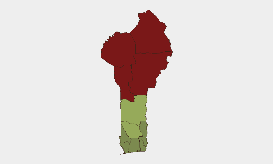
Le Bénin demeure un environnement à faible menace au niveau mondial (score composite 21), les risques de sécurité étant concentrés dans les départements frontaliers du nord. Cependant, le pays fait face à une instabilité persistante dans les départements d'Alibori, d'Atakora, de Donga et de Borgou—alimentée par une activité militante transfrontalière, le trafic et la présence de groupes armés informels liés à la crise du Sahel. Les zones méridionales et côtières (Littoral, Ouémé, Atlantique) demeurent à risque substantiellement plus faible, soutenant la poursuite des opérations commerciales et diplomatiques à Cotonou et Porto-Novo.
Développements Clés
Aucun incident de sécurité ou risque de voyage nouveau et vérifiable au Bénin n'a été identifié dans les 24–48 heures précédant le 22 juillet 2026. Les rapports en source ouverte et les flux d'actualités pour les 21–22 juillet restent clairsemés ; l'événement le plus récent daté dans les sources disponibles est :
- Glazoué (quartier Zongo), département du Zou — 20 juillet 2026 – Un incendie urbain important a détruit une partie du quartier Zongo, créant un déplacement localisé et une perturbation des infrastructures. Ceci sort de la fenêtre stricte de 24–48h mais peut affecter la logistique ou la sécurité du personnel dans la commune.
Aucun nouvel incident transfrontalier, opération d'arrestation ou développement criminel majeur n'a été signalé avec des horodatages confirmés au cours des deux derniers jours. Trois signaux d'événement détectés le 20 juillet (enquête douanière, incident Bénin–Togo, arrestation d'un opérateur dans une ville) nécessitent une corroboration supplémentaire et ne figurent pas encore dans les médias régionaux dominants ou en source ouverte.
Zones à Risque Maximal
Le Bénin septentrional—spécifiquement Alibori (92), Atakora (88), Donga (85) et Borgou (83)—détermine le profil de risque du pays. Ces départements bordent le Burkina Faso et le Niger, où opèrent des groupes militants affiliés aux franchises de l'État islamique et d'al-Qaïda. Le trafic, le recrutement par des groupes armés informels et les raids transfrontaliers occasionnels caractérisent l'environnement des menaces. Une chute nette se produit au sud de ces quatre départements ; les départements de Zou, Collines et Plateau affichent un risque modéré (45, 42, 38), tandis que les zones côtières et méridionales (Littoral, Ouémé, Atlantique) demeurent à faible risque, reflétant la proximité des pôles commerciaux et la présence réduite d'espaces non gouvernés.
Comment GeoBit Apporterait son Assistance
Les équipes de sécurité et de devoir de diligence devraient employer la Surveillance AOI et Alerte Précoce pour maintenir une surveillance persistante des départements d'Alibori et d'Atakora, avec des alertes automatisées pour les incidents transfrontaliers, les mouvements de groupes armés ou l'activité de trafic. La ROSEN multilingue et extraction d'entités sur les médias régionaux (sources en français et locales) et la ROSEN Telegram/X feront remonter les menaces émergentes oubliées par les cycles d'actualités en anglais. L'Analyse de Routage et de Réseau peut identifier les couloirs de transit plus sûrs pour le personnel ou les marchandises se déplaçant entre Cotonou et les sites de terrain du nord, évitant les points de contrôle à haut risque ou les zones d'activité militante.
Perspective sur 7 Jours
Aucune escalade imminente et aiguë n'est prévue. Les départements septentrionaux resteront sous la pression de référence liée au Sahel (trafic, militantisme informel, tension transfrontalière occasionnelle). Les opérations méridionales se poursuivent avec la diligence raisonnable standard. Surveiller la chronologie de récupération de l'incendie de Glazoué s'il affecte les chaînes d'approvisionnement locales ou le personnel. Révision recommandée des politiques de mouvement du personnel à Alibori et Atakora si les opérations ou la présence s'étendent dans ces zones.
Zones les Plus à Risque — Classées
| # | État / Région | Risque |
|---|---|---|
| 1 | Alibori Department | 92 |
| 2 | Atakora Department | 88 |
| 3 | Donga Department | 85 |
| 4 | Borgou Department | 83 |
| 5 | Zou Department | 45 |
| 6 | Collines Department | 42 |
| 7 | Plateau Department | 38 |
| 8 | Kouffo Department | 35 |
| 9 | Mono Department | 32 |
| 10 | Atlantique Department | 28 |
| 11 | Littoral | 25 |
| 12 | Ouémé Department | 22 |
Sources
Bulletins Quotidiens Précédents
Un nouveau bulletin Benin est publié chaque jour — chacun avec sa carte de risque et son CSV téléchargeable. Voici la dernière semaine ; utilisez le calendrier pour remonter plus loin.
📅 Browse every day by calendar →
Highlighted days have a brief. Tap a day for that day's map & analysis, or “csv” for that day's dataset ($5).
Atlas — our AI intelligence desk — emails them this snapshot personally. Nothing else, no list.