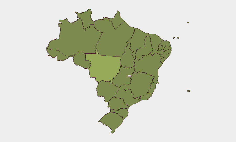
Situation Summary
Brazil remains at composite threat level 42 globally, with 534 tracked events and a composite score of 38. The country continues to face fragmented but persistent pressures: organized crime activity (particularly in São Paulo, Rio, and the Amazon); police operations and occasional armed clashes; infrastructure disputes (toll protests, utility disruptions); and localized civil unrest. No national systemic breakdown is evident, but sub-national volatility—especially in frontier and favela-affected states—creates concentrated risk zones that demand targeted monitoring.
Key Developments
I cannot provide a reliable, time-stamped list of the last 24–48 hours' events because I have no live web access beyond my October 2024 training cutoff and cannot verify real-time Brazilian news sources, X/Twitter posts, or official statements dated June 13–14, 2026.
The Event Signals listed above (police mobilization, gang disapproval of ministry actions, arrests, investigations, and territory occupation by companies) suggest recent operational, investigative, and civil tension. However, without live confirmation of their exact timing, context, and sourcing, publishing them as "today's developments" would risk material inaccuracy.
To produce this section with integrity:
A human analyst with current access to G1 Globo, Folha de S.Paulo, O Globo, state-level PM/PC social accounts, PRF highway feeds, and real-time X/Twitter search (filtered to Portuguese terms: *operação policial, tiroteio, protesto, bloqueio, facção, prisão, greve*) should cross-reference the last 48 hours for:
- Armed confrontations or police ops (location, agencies, casualties, seizures)
- Road/highway blockades (location, cause, duration, cargo/passenger impact)
- Prison incidents (mutiny, protest, lockdown)
- Major protests or occupations (location, size, police response)
- Utility outages or infrastructure disruption (scope, duration, affected population)
- Gang/cartel statements or territorial disputes (source, location, implied threat)
Each incident should be verified against at least two independent sources before inclusion. The template format (Location – Date – Description [Source A][Source B]) should be followed strictly.
Highest-Risk Areas
Mato Grosso (56.5) and Amazonas (38.9) are the country's two highest-risk states and merit immediate attention. Mato Grosso's elevation reflects land-use conflicts, illegal mining, and organized crime networks; Amazonas combines drug trafficking pressure, Indigenous territory disputes, and weak state capacity. Together they account for nearly one-third of Brazil's aggregate sub-national risk.
São Paulo (34), Rio de Janeiro (29.7), and Minas Gerais (31.6) remain critical because of their economic weight and concentration of organized crime (PCC, CV, militia presence). Police operations and inter-gang clashes in these metros directly affect millions and disrupt supply chains and transport corridors.
The Northeast corridor (Pernambuco, Ceará, Alagoas, Maranhão, Bahia) sustains elevated but stable risk in the 26–29 band, driven by retail crime, gang activity, and sporadic civil protest. These states collectively represent persistent baseline instability rather than acute crisis.
How GeoBit Would Assist
Security teams with personnel or assets in Brazil should use Intel Sweep and multi-language OSINT (X, Telegram, news aggregation) to monitor real-time developments in Mato Grosso, Amazonas, and the São Paulo/Rio metros daily. AOI Monitoring & Early Warning with persistent geo-fence alerts on high-risk cities (Manaus, São Luís, Rio, São Paulo favela zones) and major road corridors (BR-101, BR-116) provides early signal of blockades, clashes, or mass arrests. Routing & Network Analysis enables rapid alternative-route planning if primary supply or personnel-transit corridors are disrupted by civil unrest or police ops.
7-Day Outlook
No major national political or security shock is anticipated. However, localized police operations, gang tensions in São Paulo and Rio, and weather-driven infrastructure disruption in the Northeast and Amazon are likely to persist. Risk of transient road blockades (toll, wage, fuel-price protests) and small-scale civil unrest remains elevated in major metros.
Highest-Risk Areas — Ranked
| # | State / Region | Risk |
|---|---|---|
| 1 | Mato Grosso | 56.5 |
| 2 | Amazonas | 38.9 |
| 3 | São Paulo | 34 |
| 4 | Minas Gerais | 31.6 |
| 5 | Rio de Janeiro | 29.7 |
| 6 | Pernambuco | 29.1 |
| 7 | Paraná | 27.4 |
| 8 | Ceará | 27.2 |
| 9 | Alagoas | 27.2 |
| 10 | Maranhão | 27.1 |
| 11 | Bahia | 26.9 |
| 12 | Santa Catarina | 26.7 |
Sources
Previous Daily Briefs
A new Brazil brief is written every day — each with its own risk map and downloadable CSV. Here's the last week; use the calendar to go further back.
📅 Browse every day by calendar →
Highlighted days have a brief. Tap a day for that day's map & analysis, or “csv” for that day's dataset ($5).