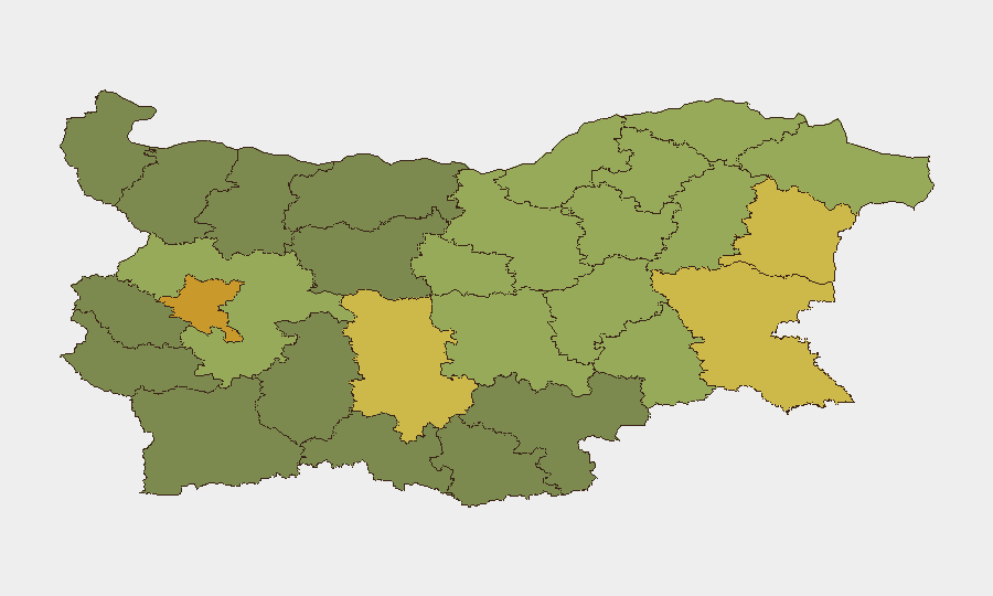
Situation Summary
Bulgaria remains a moderate-threat environment (global rank #113, composite score 8) with 16 tracked events in the current monitoring cycle. The security picture is shaped primarily by bilateral diplomatic tensions with Russia and EU institutional friction, rather than by active civil unrest or crime escalation. No significant domestic security incidents have been reported in the last 24–48 hours; the current threat posture is stable but elevated in Sofia-City and the major port cities, where geopolitical messaging activity and transnational flows create persistent friction points.
Key Developments
- 2026-07-04, Sofia-City / National: Bulgaria issued public statements opposing Russia and threatening/rejecting EU positions on unspecified matters (two separate statements, dates 2026-07-04). Nature and outcomes remain unclear from public sources; likely diplomatic or policy disagreements rather than security incidents.
- 2026-07-04, Romania–Bulgaria Border Region: A conventional military force event involving Romanian military and an employee was logged near or within Bulgarian territory. No casualty reports or escalation indicators detected; nature of interaction (exercise, border patrol, or incident) requires clarification via diplomatic or military channels.
- 2026-07-03, National: UK government issued a public statement referencing Bulgaria or Bulgarian government activity. Content and implications unknown from available sources.
- Recent (date unspecified), Multiple Regions: Flood event (ID 1103973) recorded in Bulgaria. Geographic extent, casualties, and infrastructure impact not yet quantified; likely to affect transport, utilities, or agriculture in affected sub-nationals.
- No confirmed crime, civil unrest, or travel incidents have been independently corroborated in the 24–48 hour window.
Highest-Risk Areas
Sofia-City (risk 72) and Plovdiv (risk 68) anchor Bulgaria's risk profile, with Varna and Burgas close behind—a concentration in the capital and major urban/port hubs. This pattern reflects exposure to transnational crime networks, migrant transit routes, diplomatic incidents, and infrastructure interdependencies rather than active insurgency or civil conflict. The port cities' elevated scores suggest maritime trafficking, sanctions evasion, and irregular-border activity as persistent drivers. Rural and northern regions (Ruse, Razgrad, Shumen) show lower but non-negligible risk, likely from cross-border smuggling and EU border-management friction.
How GeoBit Would Assist
Security teams with personnel or assets in Bulgaria would deploy Intel Sweep and multi-language OSINT fusion to monitor the Russian and EU diplomatic tracks in real time, capturing policy shifts and messaging that signal escalation. AOI Monitoring with persistent alerting on Sofia-City, Plovdiv, Varna, and Burgas would enable early warning of civil unrest, crime upticks, or infrastructure failures; Shodan and network analysis would support cyber-resilience checks at corporate facilities. GIS & spatial analysis paired with flood/environmental monitoring would track the reported flood event and its impact on logistics and asset accessibility.
7-Day Outlook
Bilateral diplomatic friction with Russia and EU institutional tensions are likely to persist without clear resolution signals; no near-term escalation to kinetic or mass-casualty events is forecast. The flood event will require 48–72 hours of monitoring for secondary effects on transport and utilities. Standard duty-of-care protocols—staff location tracking, supply-chain contingency, and liaison with local authorities—remain appropriate.
Highest-Risk Areas — Ranked
| # | State / Region | Risk |
|---|---|---|
| 1 | Sofia-City | 72 |
| 2 | Plovdiv | 68 |
| 3 | Varna | 65 |
| 4 | Burgas | 62 |
| 5 | Sofia | 58 |
| 6 | Ruse | 55 |
| 7 | Stara Zagora | 52 |
| 8 | Sliven | 50 |
| 9 | Shumen | 48 |
| 10 | Razgrad | 47 |
| 11 | Yambol | 45 |
| 12 | Dobrich | 44 |
Previous Daily Briefs
A new Bulgaria brief is written every day — each with its own risk map and downloadable CSV. Here's the last week; use the calendar to go further back.
📅 Browse every day by calendar →
Highlighted days have a brief. Tap a day for that day's map & analysis, or “csv” for that day's dataset ($5).
Atlas — our AI intelligence desk — emails them this snapshot personally. Nothing else, no list.