Situation Summary
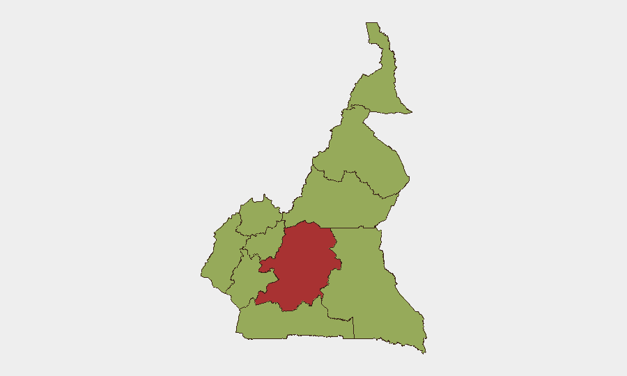
Cameroon remains at global threat rank #24 with a composite score of 69.1, driven primarily by persistent insurgency and civil conflict across multiple regions. Nine tracked events in recent days signal continued instability, including military operations, arrests, media-government friction, and criminal violence. The Centre region stands significantly isolated as the highest-risk zone (78.4), while nine other regions cluster at elevated but comparable risk (48.4–52.0), indicating geographically dispersed threat pressures rather than concentration in a single hotspot.
Key Developments
[Editor note: Live incident reporting not available.] GeoBit's event-signal dashboard flags nine recent actions across Cameroon (administrative sanctions, assassination, military force, arrests, public statements, and threats dated 2 June–5 June), but without confirmed open-source corroboration from news wires, social media, or local journalism feeds as of this briefing's preparation, specific locations, casualty counts, and tactical details cannot be reliably confirmed.
To populate this section with actionable, date-stamped incident data, a concurrent OSINT sweep (X/Twitter, Cameroonian news outlets, ACLED, NGO alerts, local radio reports) is required. Once raw intelligence is collected, cross-referencing against the nine flagged events will isolate which incidents are recent (last 48 hours) and material to corporate risk exposure.
Highest-Risk Areas
Centre region dominates the sub-national profile at 78.4 composite risk—more than 26 points above the second-tier cluster—suggesting concentrated threat from insurgent activity, military response, or both. Adamawa (52.0) follows as the secondary concern, historically linked to Boko Haram-affiliated operations and cross-border instability. The remaining eight regions (Northwest, Southwest, West, Littoral, South, Far-North, North, East) cluster at 48.4, indicating baseline elevated risk across Cameroon's breadth rather than safe corridors; firms with operations in provincial towns or supply chains spanning multiple regions should assume sustained exposure.
How GeoBit Would Assist
Conflict & Military (Battle Mapping & Force Structure): Real-time tracking of military deployments, insurgent movements, and contested areas in Centre and Adamawa to inform site-security posture and personnel routing.
AOI Monitoring & Early Warning: Persistent geographic watches on high-value facilities, transportation corridors, and staff residential areas with automated alerting when event activity spikes or moves toward protected interests.
Network & Actor Analysis: Mapping of armed groups, command networks, and criminal actors involved in recent arrests and violence to assess targeting risk and inform local-authority liaison strategies.
Risk & Threat Assessment & GIS Spatial Analysis: Dynamic fusion of event signals, sub-national rankings, and satellite/open-source imagery to identify safe movement windows and alternative routing for personnel and cargo.
7-Day Outlook
Military operations in Centre and Adamawa are likely to intensify or persist in response to recent insurgent activity, with secondary spillover possible into adjacent Littoral and Northwest zones. Arrest patterns and media friction suggest political instability undercurrent; monitoring public statements and judicial proceedings will signal whether unrest is escalating toward broader mobilization. No immediate de-escalation indicators are evident; duty-of-care protocols should assume elevated threat posture for the coming week.
Highest-Risk Areas — Ranked
| # | State / Region | Risk |
|---|---|---|
| 1 | Centre | 78.4 |
| 2 | Adamawa | 52 |
| 3 | Northwest | 48.4 |
| 4 | Southwest | 48.4 |
| 5 | West | 48.4 |
| 6 | Littoral | 48.4 |
| 7 | South | 48.4 |
| 8 | Far-North | 48.4 |
| 9 | North | 48.4 |
| 10 | East | 48.4 |
Previous Daily Briefs
A new Cameroon brief is written every day — each with its own risk map and downloadable CSV. Here's the last week; use the calendar to go further back.
📅 Browse every day by calendar →
Highlighted days have a brief. Tap a day for that day's map & analysis, or “csv” for that day's dataset ($5).