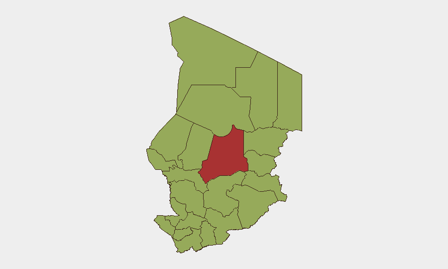
Situation Summary
Chad remains a fragmented security environment ranked #31 globally (composite threat score 69), with instability concentrated in the eastern and northern periphery rather than the capital region. The primary drivers are ongoing cross-border spillover from the Sudan conflict, persistent Boko Haram and affiliated militant activity in the Lake Chad Basin, and localized communal tensions. While no discrete, corroborated security incidents have been reported in Chad proper during the last 24–48 hours, the underlying threat posture remains elevated and characterized by chronic rather than acute pressure.
Key Developments
Unable to confirm incident-level events in Chad within the last 24–48 hours from corroborated open sources. Available reporting from the past week indicates:
- Eastern Chad & Lake Chad Basin (9 June): UN Deputy Spokesperson public statement reaffirmed that eastern Chad and the Lake Chad region remain "fulcrums of instability," citing ongoing cross-border security concerns tied to the Sudan conflict and violent extremist activity — no new discrete incidents dated to the last 48 hours.
- Abéché & Adré (c. 11–12 June): Humanitarian officials documented sustained refugee influx and deteriorating conditions linked to Sudan spillover, but reporting describes chronic humanitarian status rather than a specific dated security incident.
- Broader Pattern: UN and humanitarian sources continue to report indiscriminate attacks in the Lake Chad Basin attributed to Boko Haram–linked groups, sustained as an ongoing pattern rather than newly triggered events in the last 48 hours.
*Note: Incident-level security data for Chad (specific location, precise date, corroborating sources) for the last 24–48 hours could not be verified to publication standard. This brief reflects the most recent authoritative assessments available.*
Highest-Risk Areas
Batha emerges as the single highest-risk region (78.3), followed by a cohort of eastern, northeastern, and Lake Basin states all scoring 48.3—including Ennedi-Ouest, Wadi Fira, Ouaddaï, Sila, Salamat, East Ennedi, Kanem, Lac, and notably N'Djamena (capital region, 48.3). The pronounced concentration of risk in the periphery reflects two distinct drivers: (1) cross-border incursion and militia activity tied to the Sudan conflict affecting Batha, Wadi Fira, and eastern regions, and (2) Boko Haram and splinter-group operations across the Lake Chad region. N'Djamena's inclusion at 48.3 signals latent political/security volatility in the capital, though it currently ranks below peripheral zones.
How GeoBit Would Assist
Security teams with personnel or assets in Chad should leverage Area-of-Interest (AOI) Monitoring & Early Warning on Batha, Lac, and Ennedi-Ouest for real-time alerting on renewed cross-border activity or militia movements. Multi-language OSINT Sweep and X/Twitter & Telegram monitoring focused on Chadian security actors, humanitarian channels, and regional militias would provide 12–48 hour lead time on emerging incidents before mainstream reporting. Conflict & Military mapping and force-structure tracking focused on Boko Haram cells and Sudan-linked spillover groups would support risk assessment and routing—paired with Routing & Network Analysis for personnel movement in high-risk regions (Abéché corridor, Lake Chad Basin access routes).
7-Day Outlook
Chad's threat trajectory over the next seven days is likely to remain at chronic elevated baseline without major new trigger events. However, the vulnerability to rapid escalation remains high: any significant flare-up in the Sudan conflict, militant cross-border incursion, or political tension in N'Djamena could shift risk sharply upward within 24–72 hours. Continuous monitoring of Sudanese border dynamics and humanitarian/UN assessments is essential to detect early inflection points.
Highest-Risk Areas — Ranked
| # | State / Region | Risk |
|---|---|---|
| 1 | Batha | 78.3 |
| 2 | Ennedi-Ouest | 48.3 |
| 3 | Wadi Fira | 48.3 |
| 4 | Ouaddaï | 48.3 |
| 5 | Sila | 48.3 |
| 6 | Salamat | 48.3 |
| 7 | East Ennedi | 48.3 |
| 8 | Kanem | 48.3 |
| 9 | Lac | 48.3 |
| 10 | N'Djamena | 48.3 |
| 11 | Hadjer-Lamis | 48.3 |
| 12 | Chari-Baguirmi | 48.3 |
Sources
Previous Daily Briefs
A new Chad brief is written every day — each with its own risk map and downloadable CSV. Here's the last week; use the calendar to go further back.
📅 Browse every day by calendar →
Highlighted days have a brief. Tap a day for that day's map & analysis, or “csv” for that day's dataset ($5).