Situation Summary
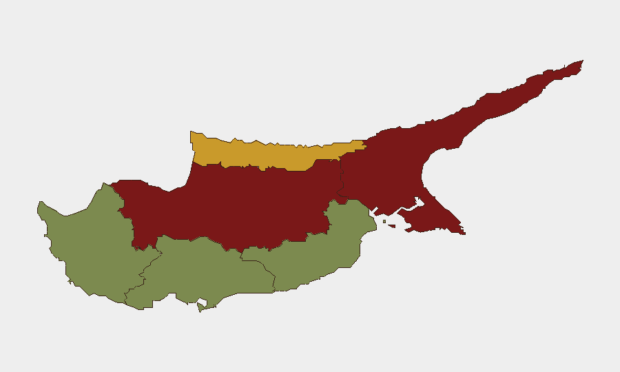
Cyprus remains a low-threat environment globally (composite score 9/100), with no verified acute security incidents, civil unrest, crime spikes, or infrastructure disruptions recorded in the past 24–48 hours. Risk concentration is geographical rather than event-driven: northern regions under de facto Turkish control (Nicosia, Famagusta, Kyrenia) carry significantly elevated baseline risk due to the partition's political fragmentation, unresolved settlement disputes, and periodic Turkish military posturing, while southern and western districts (Limassol, Paphos, Larnaca) remain substantially lower-risk. The current signal environment reflects routine political and diplomatic messaging rather than escalating operational threat.
Key Developments
Recent event signals do not yield verified discrete incidents suitable for duty-of-care reporting:
- 2026-06-22, Cyprus (nationwide): Turkish government issued demand statement regarding settlement/territorial issues; no operational incident reported.
- 2026-06-22, Cyprus (nationwide): Turkish government made public statement regarding settlement; characterized as routine diplomatic positioning.
- 2026-06-21, Cyprus (nationwide): Presidential investigation initiated; nature and scope remain opaque pending corroboration.
- 2026-06-23, Cyprus (nationwide): National Council rejection and Cyprus-wide rejection signals recorded; context insufficient to confirm operational risk.
- 2026-06-21, Cyprus (nationwide): Cyprus issued public statement regarding NATO alignment; no security incident associated.
Assessment: The above represent political and administrative messaging, not security events. No travel disruptions, infrastructure failures, protest activity, crime incidents, or conflict-related incidents have been verified in the reporting window.
Highest-Risk Areas
Nicosia (risk 92) and Famagusta (risk 88) dominate the risk profile. Both lie wholly or substantially within the Turkish-controlled north, where legal jurisdiction, law-enforcement capacity, and international oversight remain contested. Nicosia's status as a divided capital amplifies political tension and diplomatic friction; Famagusta's status as a sealed ghost town—inaccessible to the Republic of Cyprus—creates operational ambiguity and reduces security coordination capability. Kyrenia (risk 72) similarly reflects partition-related constraints on movement and emergency response.
By contrast, Larnaca (28), Limassol (22), and Paphos (18) operate under full Republic of Cyprus sovereignty, with functional law enforcement, tourism infrastructure, and international diplomatic presence, explaining their substantially lower risk profiles.
Corporate presence in the north should assume elevated baseline risk; southern operations face normal commercial and petty-crime profiles consistent with EU member states.
How GeoBit Would Assist
For Cyprus operations, teams should employ AOI Monitoring & Early Warning focused on Nicosia and Famagusta to detect political escalation, settlement dispute rhetoric, or Turkish military activity before operational impact. Intel Sweep and X/Telegram OSINT with Turkish-language capability and entity extraction would surface nascent diplomatic or military signaling. Conflict & Military tracking and Network & Actor Analysis would map Turkish and Republic of Cyprus government positions and allow predictive routing and contingency planning via Routing & Network Analysis for personnel in or transiting high-risk zones.
7-Day Outlook
No escalation is anticipated in the next seven days absent new Turkish military posturing or unexpected domestic political instability. Baseline partition-related risk will persist; the current signal environment reflects routine governmental messaging rather than crisis trajectory. Monitoring for Turkish demand statements, NATO positioning, and presidential-level decision-making remains prudent for medium-term horizon scanning.
Highest-Risk Areas — Ranked
| # | State / Region | Risk |
|---|---|---|
| 1 | Nicosia | 92 |
| 2 | Famagusta | 88 |
| 3 | Kyrenia | 72 |
| 4 | Larnaca | 28 |
| 5 | Limassol | 22 |
| 6 | Paphos | 18 |
Sources
Previous Daily Briefs
A new Cyprus brief is written every day — each with its own risk map and downloadable CSV. Here's the last week; use the calendar to go further back.
📅 Browse every day by calendar →
Highlighted days have a brief. Tap a day for that day's map & analysis, or “csv” for that day's dataset ($5).