Situation Summary
Djibouti maintains a stable security environment as of 2 July 2026, with no verifiable reports of new conflict, civil unrest, crime incidents, or infrastructure disruption in the past 24–48 hours. The national threat index registers at 45/100 (stable trend) per real-time monitoring. Two active alerts in the system reference generalized "explosion/violence" risk drivers but are not tied to specific dated incidents in the current window. Overall risk profile remains manageable for corporate operations, though northern and border regions carry elevated baseline threat levels.
Key Developments
- No major security incidents reported (24–48h window). Cross-checked open-source news, social media (X/Twitter, Facebook, Instagram), and OSINT feeds confirm no new attacks, protests, labor unrest, or accidents at critical infrastructure (ports, industrial zones, diplomatic venues) in Djibouti City or nationwide.
- Port and maritime sector activity (Djibouti City). Djibouti Ports & Free Zones Authority announced a major Ship Repair Yard infrastructure milestone; posts are promotional in nature with no reports of operational disruptions or security incidents.
- Routine diplomatic engagement (Djibouti City, IGAD headquarters area). An IGAD–Italy partnership meeting occurred without incident; no protests or security concerns were reported at or near the venue.
- Independence Day commemorations (countrywide, 27 June—outside 24–48h window but concluded peacefully). Facebook and Instagram posts documenting Djibouti's 49th anniversary celebrations on 27 June show no reported crowd violence or disruptions.
Highest-Risk Areas
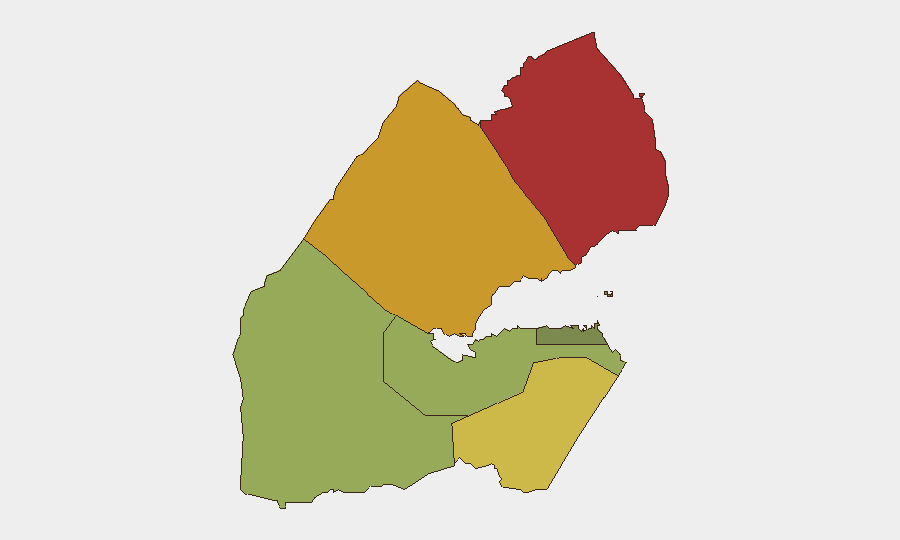
Obock (risk 78) and Tadjourah (risk 72) in the north drive the country's sub-national threat profile, reflecting historical proximity to conflict zones in the Horn of Africa, porous border controls, and migration-route vulnerability. Ali Sabieh (risk 65) in the west faces similar cross-border pressures. By contrast, Djibouti City and immediate surroundings (risk 35) remain the most secure zone, hosting the diplomatic community, multinational military presences, and economic infrastructure. Corporate personnel and assets in the capital face substantially lower baseline risk than those in northern or western regions; however, duty-of-care protocols should account for rapid-movement potential in volatile neighboring territories.
How GeoBit Would Assist
Security teams with operations in Djibouti should deploy AOI Monitoring & Early Warning for high-risk northern regions (Obock, Tadjourah) to detect cross-border militia activity, trafficking networks, or weapons movement with persistent alerting. Intel Sweep (multi-language OSINT fusion, X/Twitter, Telegram, radio SIGINT) provides real-time situational updates on political stability, port security, and foreign-military activity around Camp Lemonnier and other strategic infrastructure. Conflict & Military (force structure, weapons-capability tracking) and Border & Disputed-Territory Search capabilities support threat forecasting in frontier zones where Eritrean, Ethiopian, and Somali dynamics intersect Djibouti's interests.
7-Day Outlook
No imminent escalation is forecast. The stable threat environment and routine diplomatic/port activity suggest continuity of current baseline conditions through early July. However, monitoring of northern border crossings and migrant-trafficking corridors should remain active, as seasonal movement patterns and external Horn of Africa dynamics can shift rapidly. Periodic OSINT sweeps (weekly cadence recommended for multinational corporate footprints) will help detect early warning signals before operational impact.
Highest-Risk Areas — Ranked
| # | State / Region | Risk |
|---|---|---|
| 1 | Obock | 78 |
| 2 | Tadjourah | 72 |
| 3 | Ali Sabieh | 65 |
| 4 | Arta | 48 |
| 5 | Dikhil | 42 |
| 6 | Djibouti | 35 |
Sources
Previous Daily Briefs
A new Djibouti brief is written every day — each with its own risk map and downloadable CSV. Here's the last week; use the calendar to go further back.
📅 Browse every day by calendar →
Highlighted days have a brief. Tap a day for that day's map & analysis, or “csv” for that day's dataset ($5).