Situation Summary
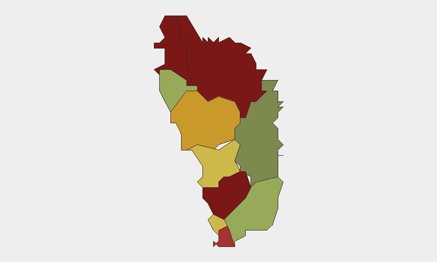
Dominica presents a composite threat score of 5 with no tracked major security incidents in the past 24–48 hours. Open-source reporting confirms no corroborated violent crime spikes, protests, infrastructure disruptions, or acute civil-unrest events in-country during 18–20 June 2026. The security environment remains characterized by localized crime and socioeconomic vulnerabilities concentrated in specific parishes rather than systemic or escalating national instability.
Key Developments
No significant security incidents confirmed in Dominica during 18–20 June 2026. Verified open-source reporting (GIS Dominica updates, local news roundups, and regional news feeds) documents no fresh violent crime, unrest, infrastructure failure, or formal threat-level changes during this window. Official communications from 17–20 June focus on domestic policy, health initiatives, and cultural events rather than security alerts or emergency declarations.
Highest-Risk Areas
Saint Andrew Parish (risk 92), Saint John Parish (risk 88), and Saint George Parish (risk 81) account for the largest composite risk concentrations and warrant primary focus for corporate duty-of-care planning. Risk elevation in these northern and central parishes reflects historical crime rates, socioeconomic conditions, and limited state capacity rather than active conflict or imminent escalation. Personnel and asset placements in Saint David Parish (risk 35) and Saint Patrick Parish (risk 48) face materially lower documented exposure. Risk stratification suggests targeting of monitoring and protective resources toward the top three parishes will yield the highest return on security investment.
How GeoBit Would Assist
Area-of-Interest (AOI) Monitoring & Early Warning would establish persistent, automated watch over high-risk parishes (Saint Andrew, Saint John, Saint George) with real-time alerting to trafficking, violent-crime clusters, or protest formation. Intel Sweep, OSINT Fusion & Corroboration capabilities enable rapid cross-verification of emerging rumors or social-media signals against credible news and official channels, reducing false alarms and clarifying ground truth when incidents do occur. Routing & Network Analysis and GIS & Spatial Analysis support alternative-route planning and safe-haven identification for mobile personnel, particularly those transiting or working in high-risk parishes.
7-Day Outlook
No indicators suggest acute deterioration or major incident onset in the next 7 days. Baseline socioeconomic and crime drivers remain stable; monitoring should focus on sustaining parish-level granularity and rapid incident detection rather than preparing for systemic escalation. Routine duty-of-care protocols (personnel movement restrictions in high-risk areas, communication check-ins, local liaison engagement) remain appropriate and proportionate to the threat environment.
Highest-Risk Areas — Ranked
| # | State / Region | Risk |
|---|---|---|
| 1 | Saint Andrew Parish | 92 |
| 2 | Saint John Parish | 88 |
| 3 | Saint George Parish | 81 |
| 4 | Saint Mark Parish | 78 |
| 5 | Saint Joseph Parish | 72 |
| 6 | Saint Paul Parish | 68 |
| 7 | Saint Luke Parish | 62 |
| 8 | Saint Peter Parish | 55 |
| 9 | Saint Patrick Parish | 48 |
| 10 | Saint David Parish | 35 |
Previous Daily Briefs
A new Dominica brief is written every day — each with its own risk map and downloadable CSV. Here's the last week; use the calendar to go further back.
📅 Browse every day by calendar →
Highlighted days have a brief. Tap a day for that day's map & analysis, or “csv” for that day's dataset ($5).