Situation Summary
DR Congo remains a high-conflict environment (global rank #32, composite score 53.2) with escalating drone warfare and shifting frontlines in the eastern provinces, particularly around M23-controlled territories and government-held positions. The conflict has intensified from ground-based engagement to unmanned systems operations targeting both military infrastructure and civilian areas, raising collateral-damage risk and complicating situational awareness. North Kivu and Tshopo provinces show the highest threat concentrations, while secondary conflict zones in South Kivu and Kasai sustain militia activity and displacement. Regional mediation efforts have yielded limited de-escalation, and UN Security Council statements confirm the conflict's potential for further regionalization involving Rwanda and Burundi.
Key Developments
- Goma (North Kivu) – Government drone strike on civilian neighborhood. M23 accused Congolese forces of conducting a drone attack on a residential area, killing several civilians including a French humanitarian worker. This represents the first reported drone strike on Goma since M23's seizure of the city and signals escalation in urban air operations.
- Kisangani airbase (Tshopo) – M23 drone attack on FARDC logistics hub. M23 conducted a drone strike on a major government military airbase in central DRC, demonstrating operational reach far beyond traditional eastern frontlines and exposing vulnerability of critical supply infrastructure.
- Rumangabo conservation facility (North Kivu) – FARDC/contractor drone strike. Congolese forces targeted a nature reserve facility near a military base ~25 km north of Goma, damaging infrastructure and highlighting the integration of unmanned systems in ground-support operations.
- North of Goma – Congolese drone strike on M23 positions. Government forces conducted a counter-strike on M23 main base area to degrade rebel capabilities amid sustained ground fighting, indicating an intensified bilateral air campaign.
- Rubaya (Masisi, North Kivu) – Failed FARDC/Wazalendo offensive. Pro-government forces launched an unsuccessful operation against M23-held positions in this strategic mining and transit corridor, underscoring continued instability in government-controlled zones.
- Ruzizi Plain (South Kivu) – M23 withdrawal and militia clashes. M23 unilaterally withdrew from this cross-border zone while Wazalendo pro-government militias engaged M23 elements, reflecting dynamic frontline shifts and raising localized displacement and transit risks.
- Kalehe highlands (South Kivu) – Ongoing M23–Wazalendo combat. Active fighting in rural mountainous terrain complicates humanitarian access and overland movement between South Kivu and northern zones.
- UN Security Council session – Regional escalation warning. Council members highlighted worsening security across eastern DRC and the Great Lakes region, with DRC–Rwanda–Burundi tensions sustained despite ongoing mediation efforts.
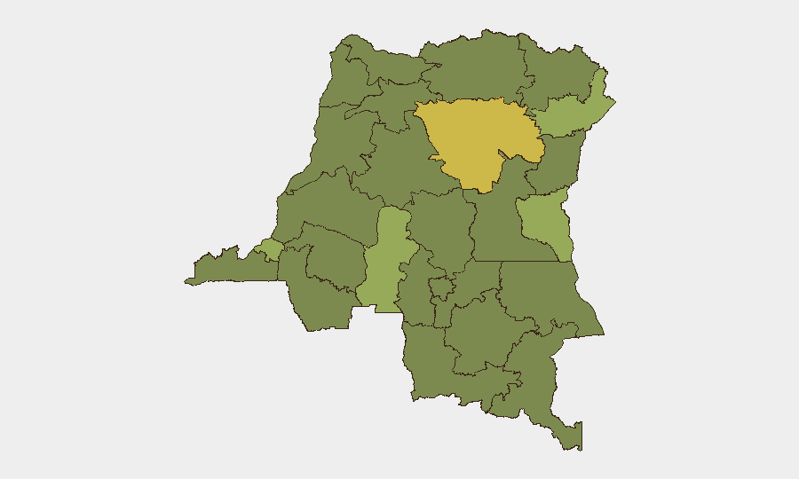
Highest-Risk Areas
Tshopo province (risk 67.2) dominates the ranking following the M23 drone strike on Kisangani airbase, signaling the conflict's northward expansion. Kinshasa (51.1) registers elevated risk due to urban security threats and governance instability. Ituri and South Kivu (both 44.2) remain active conflict zones with militia presence and frontline volatility. The sustained tactical activity in North Kivu—though not formally listed in top-five rankings—underpins the national threat level and drives humanitarian and cross-border risks across the eastern corridor.
How GeoBit Would Assist
Security teams would employ AOI Monitoring & Early Warning to track real-time drone activity and frontline shifts around key facilities and transit routes. Battle Mapping and Conflict & Military modules provide force-structure updates and weapons-capability assessment (drone types, strike patterns). Routing & Network Analysis supports safe-passage planning by identifying alternative routes around active combat zones, while Intel Sweep and OSINT fusion maintain continuous monitoring of militia movements, M23 communications, and government operational announcements via social media and regional broadcasts.
7-Day Outlook
Drone strikes are likely to continue as both M23 and FARDC leverage unmanned systems to target logistics, military bases, and contested territory. Ground operations around Goma, Masisi, and the Ruzizi Plain will remain volatile, with frontline positions subject to tactical shifts. Humanitarian access corridors and civilian infrastructure in North and South Kivu face compounded risk from combined air and ground operations.
Highest-Risk Areas — Ranked
| # | State / Region | Risk |
|---|---|---|
| 1 | Tshopo | 67.2 |
| 2 | Kinshasa | 51.1 |
| 3 | Ituri | 44.2 |
| 4 | South Kivu | 44.2 |
| 5 | Kasai | 41.9 |
| 6 | Maniema | 37.2 |
| 7 | Sud-Ubangi | 37.2 |
| 8 | Équateur | 37.2 |
| 9 | Nord-Ubangi | 37.2 |
| 10 | Mongala | 37.2 |
| 11 | Lower Uele | 37.2 |
| 12 | Tshuapa | 37.2 |
Sources
Previous Daily Briefs
A new DR Congo brief is written every day — each with its own risk map and downloadable CSV. Here's the last week; use the calendar to go further back.
📅 Browse every day by calendar →
Highlighted days have a brief. Tap a day for that day's map & analysis, or “csv” for that day's dataset ($5).