Situation Summary
East Timor remains a low-threat environment globally (composite threat score 4; no tracked events in the current assessment window). The country presents a fragmented sub-national risk profile, with Dili (capital, risk 72) and the western districts of Liquiçá and Baucau driving the majority of assessed risk. No confirmed security incidents, civil unrest, or infrastructure disruptions have been reported in the last 24–48 hours.
Key Developments
No discrete security events have been confirmed in East Timor within the last 24–48 hours. Available open-source reporting does not evidence active conflict, organized crime incidents, protest activity, or political instability during this window.
Note: GeoBit's live web research (X/Twitter, news feeds) for the period 2026-06-11 to 2026-06-13 returned no incident-grade material. If specific recent developments are known to your organization, submission of those reports or links will enable rapid triage and integration into this brief.
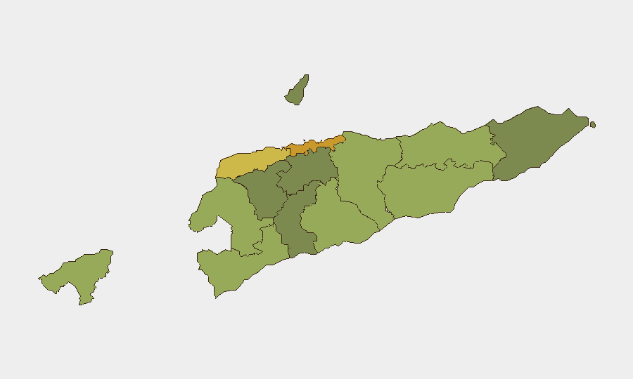
Highest-Risk Areas
Dili (risk 72) significantly outpaces other districts and warrants priority monitoring; the capital's concentration of government, foreign missions, transport hubs, and urban density typically correlates with higher crime, protest, and accident risk. Liquiçá (62) and Baucau (58) form a secondary tier, likely reflecting historical communal tensions, border-area dynamics (Liquiçá borders Indonesia), and economic marginalization. The remaining districts (Cova Lima, Bobonaro, Oecussi-Ambeno) range between 48–55, reflecting mixed drivers: western border proximity, inter-community friction, and infrastructure gaps. Southern and eastern districts (Aileu, Ermera, Ainaro) register as comparatively lower-risk but should not be assumed stable for mission-critical operations.
How GeoBit Would Assist
Corporate security teams with personnel or assets in East Timor should employ AOI (Area-of-Interest) Monitoring & Early Warning with persistent watch on Dili, Liquiçá, and Baucau to detect emerging unrest, crime spikes, or infrastructure disruption in near-real time. Intel Sweep and multi-language OSINT (X/Telegram, local news, YouTube) will capture incident reporting and sentiment shifts faster than mainstream wire services. GIS & Spatial Analysis combined with Routing & Network Analysis enables security teams to pre-plan alternative routes, safe zones, and evacuation corridors for personnel in high-risk districts, while Risk & Threat Assessment can model duty-of-care exposure (personnel density, asset exposure, incident probability) by district and timeline.
7-Day Outlook
No significant escalation of security conditions is forecast for the next seven days based on current signals and historical seasonality. Dili and western districts will continue to merit elevated monitoring posture as a baseline precaution. Duty-of-care teams should maintain standard protocols and position for rapid information-sharing if incidents emerge.
Next Update: 2026-06-14 (or on-demand if significant events occur).
Highest-Risk Areas — Ranked
| # | State / Region | Risk |
|---|---|---|
| 1 | Dili | 72 |
| 2 | Liquiçá | 62 |
| 3 | Baucau | 58 |
| 4 | Cova Lima | 55 |
| 5 | Bobonaro | 53 |
| 6 | Oecussi-Ambeno | 48 |
| 7 | Manufahi | 45 |
| 8 | Viqueque | 42 |
| 9 | Manatuto | 40 |
| 10 | Ainaro | 38 |
| 11 | Ermera | 36 |
| 12 | Aileu | 32 |
Sources
Previous Daily Briefs
A new East Timor brief is written every day — each with its own risk map and downloadable CSV. Here's the last week; use the calendar to go further back.
📅 Browse every day by calendar →
Highlighted days have a brief. Tap a day for that day's map & analysis, or “csv” for that day's dataset ($5).