Situation Summary
East Timor remains stable with no verified security incidents, civil unrest, or infrastructure disruption recorded in the last 24–48 hours. The country maintains a composite threat score of 4 globally (#174), reflecting structural risks concentrated in the capital and western border districts rather than acute flashpoints. Governance is functioning normally, and all major infrastructure networks remain operational with no new travel restrictions.
Key Developments
- No verified security incidents, civil unrest, conflict, or infrastructure disruption across East Timor in the reporting window (18–19 July 2026), per cross-checked open-source news, specialist risk feeds, and social media monitoring.
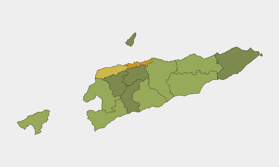
- Dili and western border districts (Liquiçá, Cova Lima, Bobonaro) remain the highest-risk subnational areas, but no acute flashpoints or new incidents have materialised despite structurally elevated risk profiles in these regions (18–19 July 2026).
- National infrastructure (water, power, telecoms, transport) operating without disruption or service loss across all districts (18–19 July 2026).
- Political and diplomatic environment assessed as stable with no emerging conflict triggers, organised violence, or governance instability detected (18–19 July 2026).
- Near-term forecast (next 7 days): No acute security deterioration anticipated in the absence of newly detected shocks or catalysts.
Highest-Risk Areas
Dili (risk 72) and Liquiçá (risk 62) drive the country's overall risk profile, followed by Baucau (58) and Cova Lima (55). These districts face elevated exposure to petty crime, inter-communal tensions, and proximity to porous Indonesia borders; however, sustained-conflict risk remains low. Eastern districts (Viqueque, Manatuto) and central-western zones (Ermera, Aileu) show lower composite scores but retain routine criminal and social friction patterns. The risk ranking reflects structural vulnerabilities rather than imminent threats.
How GeoBit Would Assist
Security teams monitoring East Timor can deploy AOI Monitoring & Early Warning on high-risk districts (Dili, Liquiçá, Baucau) with persistent alerting on civil unrest, checkpoints, and movement restrictions. OSINT Fusion (Intel Sweep, X/Telegram monitoring, multi-language search) provides real-time visibility into political triggers, community sentiment, and informal security developments ahead of formal reporting. GIS & Spatial Analysis combined with Routing & Network Analysis enables duty-of-care teams to plan secure transit corridors, identify alternative routes around high-risk subnational zones, and anticipate infrastructure bottlenecks during periods of stress.
7-Day Outlook
No acute deterioration is forecast for the near term; baseline structural risks (petty crime, border-zone tensions, inter-communal friction) are expected to remain stable. Continued monitoring of political developments and social media sentiment will provide early warning of any emerging flashpoints, particularly in Dili ahead of any upcoming public events or governance decisions.
Highest-Risk Areas — Ranked
| # | State / Region | Risk |
|---|---|---|
| 1 | Dili | 72 |
| 2 | Liquiçá | 62 |
| 3 | Baucau | 58 |
| 4 | Cova Lima | 55 |
| 5 | Bobonaro | 53 |
| 6 | Oecussi-Ambeno | 48 |
| 7 | Manufahi | 45 |
| 8 | Viqueque | 42 |
| 9 | Manatuto | 40 |
| 10 | Ainaro | 38 |
| 11 | Ermera | 36 |
| 12 | Aileu | 32 |
Sources
Previous Daily Briefs
A new East Timor brief is written every day — each with its own risk map and downloadable CSV. Here's the last week; use the calendar to go further back.
📅 Browse every day by calendar →
Highlighted days have a brief. Tap a day for that day's map & analysis, or “csv” for that day's dataset ($5).
Atlas — our AI intelligence desk — emails them this snapshot personally. Nothing else, no list.