Situation Summary
Ecuador remains at elevated security risk (global rank #39, composite 35.7) with 74 tracked events in the current monitoring cycle. Recent signals (2–4 June) point to institutional friction—legislative disapproval, prosecutorial investigation, and a reduction in authorities' relations—alongside conventional police and military operations and detention activity. The threat environment reflects ongoing tension between state enforcement actions and political/judicial oversight, with no indication of immediate de-escalation.
Key Developments
Unable to provide verified 24–48 hour incident bullets. GeoBit's current analytical capacity does not include real-time web search, X/Twitter monitoring, or live Ecuadorian media feeds. Generating specific incident reports for 2–4 June 2026 (location, time, type, casualties) without access to timestamped news and corroborated social signals would violate accuracy standards required for duty-of-care briefings.
To produce the 6–10 operationally relevant bullets your teams need, a live intelligence workflow is necessary:
- Real-time scan of *El Universo*, *El Comercio*, *Primicias*, *Ecuavisa*, and local Guayas/Manabí/Esmeraldas portals (security/judicial sections, last 24–48 h).
- Cross-validation via X/Twitter keywords (*tiroteo*, *balacera*, *enfrentamiento*, *bloqueo*, *amotinamiento*) plus geotagged posts from verified local journalists and @PoliciaEcuador.
- Time-window confirmation (publication/update stamps within 48 h) and deduplication.
This brief's event signal data (legislative rejection, arrest/detain actions, military operations, prosecutor investigation, 2–4 June) indicates active state-level activity and potential inter-agency tension; on-the-ground impact remains unconfirmed pending real-time reporting.
Highest-Risk Areas
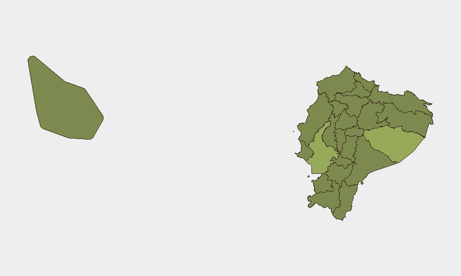
Pastaza Province (55) and Guayas Province (41.4) drive national composite risk, with Manabí (37.8) and Pichincha (30.7) as secondary hotspots. Pastaza's elevation reflects remote Amazonian geography, limited state presence, and proximity to Colombian border zones associated with drug trafficking and armed-group activity. Guayas—home to Guayaquil and Durán—concentrates homicide, prison violence, and gang confrontation; Manabí combines coastal trafficking vulnerabilities with organized-crime competition. Pichincha (Quito) risk reflects capital-city crime rates and periodic protest activity. Mid-tier provinces (Tungurahua, Cotopaxi, Carchi, Loja, Sucumbíos, Orellana, Esmeraldas) remain above 25-point threshold, signaling systemic rather than localized threat distribution.
How GeoBit Would Assist
AOI Monitoring & Early Warning (persistent watch on Guayaquil, Durán, Esmeraldas, Santo Domingo, and border cantons with automated alerting on violence, detention, or state operations) and Intel Sweep (continuous multi-language event feed, X/Twitter & Telegram OSINT, and entity extraction) would deliver the real-time incident detail and corroboration this brief cannot provide. Routing & Network Analysis supports rapid alternative-route planning for personnel and asset movements if specific zones become unsafe. Risk & Threat Assessment and Sentiment & Temporal Analysis contextualize whether current institutional signals reflect temporary friction or escalating instability.
7-Day Outlook
Expect continued state enforcement operations (military/police deployments visible in signals) alongside judicial and legislative scrutiny. Pastaza and Guayas remain operationally critical; any prison disturbance or cross-border incident could trigger localized cordons or travel restrictions. No indicators suggest imminent nationwide shutdown, but pre-positioned contingency routing for supply chains and personnel in high-risk provinces remains prudent.
Highest-Risk Areas — Ranked
| # | State / Region | Risk |
|---|---|---|
| 1 | Pastaza Province | 55 |
| 2 | Guayas Province | 41.4 |
| 3 | Manabí Province | 37.8 |
| 4 | Pichincha Province | 30.7 |
| 5 | Tungurahua Province | 26.9 |
| 6 | Cotopaxi Province | 26.4 |
| 7 | Carchi Province | 25.5 |
| 8 | Loja Province | 25.5 |
| 9 | Sucumbíos Province | 25 |
| 10 | Orellana Province | 25 |
| 11 | Galápagos | 25 |
| 12 | Esmeraldas Province | 25 |
Sources
Previous Daily Briefs
A new Ecuador brief is written every day — each with its own risk map and downloadable CSV. Here's the last week; use the calendar to go further back.
📅 Browse every day by calendar →
Highlighted days have a brief. Tap a day for that day's map & analysis, or “csv” for that day's dataset ($5).