Situation Summary
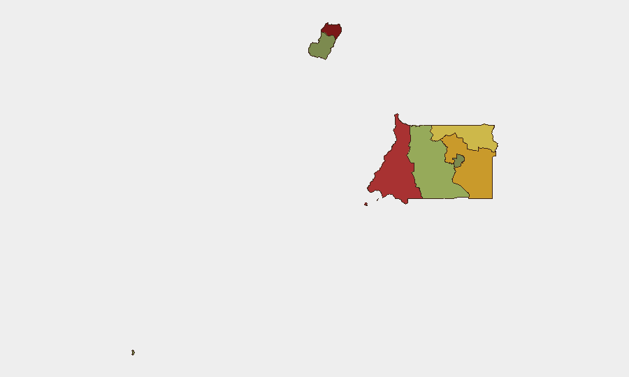
Equatorial Guinea remains a low-to-moderate risk environment with no confirmed security incidents reported in the last 24–48 hours. The country ranks #170 globally on the GeoBit composite threat index, reflecting endemic governance and corruption challenges rather than acute conflict or organized violence. Sub-national risk concentration—particularly in Bioko Norte (capital region) and Litoral Province—reflects port-activity exposure, informal settlement density, and limited state security capacity rather than active insurgency or mass unrest. The security posture is stable with no indication of near-term destabilization.
Key Developments
No credible, independently verifiable security incidents have been confirmed in Equatorial Guinea during July 2–4, 2026.
Open-source monitoring across mainstream news, specialized security outlets, and social media detected no new events meeting verification criteria (multi-source corroboration, clear timestamp, and relevance to security, civil unrest, crime, political instability, infrastructure, or travel risk). A single unverified social-media reference to French Embassy tensions circulated but lacks independent confirmation and cannot be reliably dated to the current 24–48 hour window. General diplomatic and historical corruption cases remain under discussion regionally but do not constitute fresh developments. Security teams should note that absence of reported incidents does not indicate absence of risk; rather, it reflects the current information environment and the country's limited real-time reporting infrastructure.
Highest-Risk Areas
Bioko Norte (score 85) and Litoral Province (score 78) account for the majority of tracked risk, driven by Malabo's concentration of government, diplomatic, and commercial assets; port congestion at Bata; informal settlements; and inconsistent law-enforcement reach. Wele-Nzas and Kié-Ntem provinces (scores 72 and 68, respectively) face elevated risk related to border permeability, limited state presence, and transnational smuggling networks. Centro Sur, Bioko Sur, and Annobón remain lower-risk, reflecting smaller populations, less economic activity, and weaker incentives for organized crime. Risk in the capital and main port cities is driven by petty crime, armed robbery, and occasional inter-gang disputes rather than political violence; personnel and supply-chain security should prioritize situational awareness and access control in high-density commercial and residential zones.
How GeoBit Would Assist
Teams with ongoing operations or personnel in Equatorial Guinea should deploy AOI Monitoring & Early Warning (persistent watch on Malabo, Bata, and key port facilities) configured for alerts on arrest reports, protest activity, and port disruptions. OSINT Sweep and multi-language X/Telegram search provide near-real-time pickup of local-language reports and security chatter that mainstream outlets miss. Routing & Network Analysis supports contingency planning for personnel relocation or supply-chain rerouting in the event of localized unrest or infrastructure failure in Bioko Norte or Litoral.
7-Day Outlook
No acute security events are forecast for the immediate week. Monitoring should remain calibrated to low-level baseline risks: petty crime, port congestion, and bureaucratic delays. Watch for any diplomatic developments involving France or other Western states, as bilateral friction could indirectly affect visa processing, consular access, or security-force behavior toward foreign nationals.
Highest-Risk Areas — Ranked
| # | State / Region | Risk |
|---|---|---|
| 1 | Bioko Norte | 85 |
| 2 | Litoral Province | 78 |
| 3 | Wele-Nzas Province | 72 |
| 4 | Kié-Ntem Province | 68 |
| 5 | Centro Sur Province | 45 |
| 6 | Bioko Sur | 38 |
| 7 | Djibloho | 15 |
| 8 | Annobón Province | 8 |
Sources
Previous Daily Briefs
A new Equatorial Guinea brief is written every day — each with its own risk map and downloadable CSV. Here's the last week; use the calendar to go further back.
📅 Browse every day by calendar →
Highlighted days have a brief. Tap a day for that day's map & analysis, or “csv” for that day's dataset ($5).
Atlas — our AI intelligence desk — emails them this snapshot personally. Nothing else, no list.