Situation Summary
Eritrea remains a low-frequency conflict environment globally (rank #202, composite threat score 3) with no confirmed security incidents recorded in the last 24–48 hours. However, open-source reporting and social media activity indicate ongoing risk signalling related to Eritrea–Ethiopia border tensions, alleged forced military conscription operations, and information operations—none with precise, independently verified dates or locations in the immediate reporting window. The security picture is characterized more by rhetorical escalation and unconfirmed allegations than by discrete, documented incidents affecting civilians or corporate operations within Eritrea proper.
Key Developments
No reliably corroborated, clearly dated security incidents specific to Eritrea territory were confirmed in the last 24–48 hours from indexed open-source channels. Available social media activity reflects:
- Risk signalling (Eritrea–Tigray border region, date unspecified): Analytical commentary warns of potential wider conflict between Eritrea and Ethiopia, citing alleged "low-cost destabilization" and armed-group activity, but lacks precise incident dating or independent news verification.
- Conscription allegations (Tigray/Eritrea interface, timing unclear): Unverified Facebook reports allege mass security-service round-ups of young civilians for forced military conscription, without corroborating news sources or specific date confirmation.
- Information operations (Mekelle vicinity, timing unclear): Alleged Eritrean intelligence-linked social media campaign reported to target peace efforts, but without independent confirmation or precise timing.
- Official rhetorical posture (X, recent): Senior Eritrean official Yemane G. Meskel defended national defense policies and dismissed external criticism, indicating elevated diplomatic tension but no discrete security event.
Assessment: Absence of confirmed incidents does not indicate absence of risk; rather, Eritrea's media environment and access constraints limit real-time visibility. Corporate and duty-of-care teams should treat the absence of reported incidents as a monitoring gap, not a safety signal.
Highest-Risk Areas
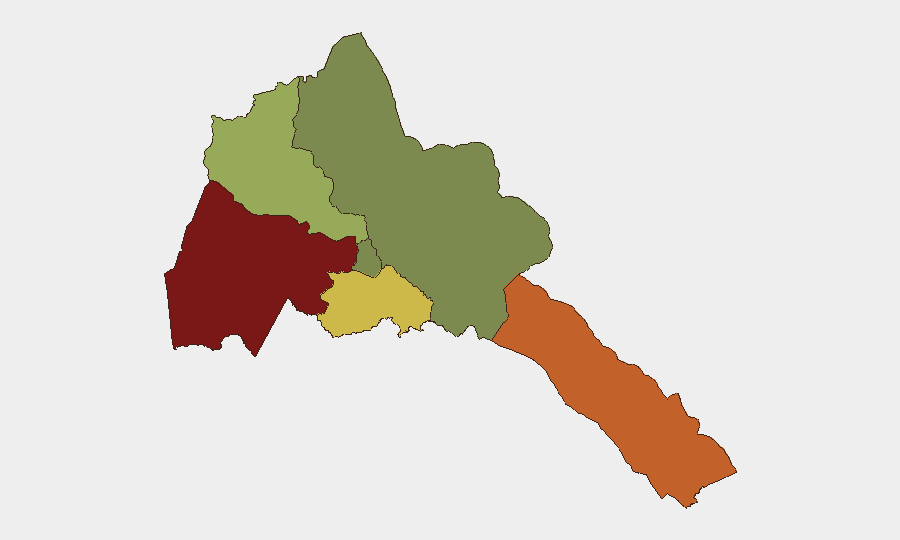
Gash-Barka (risk 92) and Southern Red Sea Region (risk 75) dominate the sub-national threat landscape, driven by proximity to the Eritrea–Ethiopia border, historical conflict activity, and alleged armed-group presence. Debub Region (risk 68) reflects similar border-adjacent vulnerabilities. By contrast, Maekel Region (risk 18)—which includes the capital Asmara—and Northern Red Sea Region (risk 0) present substantially lower composite risk. This geographic concentration suggests that security concerns for personnel or assets in Eritrea are heavily weighted toward western and southern borderlands; operations or travel in or near Asmara face significantly lower incident probability based on current tracking.
How GeoBit Would Assist
Teams with people or assets in Eritrea should use AOI Monitoring & Early Warning on Gash-Barka and Southern Red Sea Region to establish persistent, alert-enabled watch on border and conscription activity. OSINT Fusion & Corroboration (multi-language social media, Telegram, and regional news feeds) would separate confirmed incidents from unverified allegations and establish precise geolocation and dating. Risk & Threat Assessment products tied to Network & Actor Analysis would clarify Eritrean security-service and armed-group movements relevant to duty-of-care exposure.
7-Day Outlook
No imminent change in Eritrea's overall threat profile is indicated, though Eritrea–Ethiopia border rhetoric remains elevated and unconfirmed reports of conscription and intelligence operations suggest underlying instability. Organizations should maintain heightened monitoring on western and southern zones while treating the absence of confirmed incidents in the capital region as a relative—not absolute—safety indicator. Escalation risk remains tied to broader Horn of Africa dynamics rather than to discrete Eritrea-internal events.
Highest-Risk Areas — Ranked
| # | State / Region | Risk |
|---|---|---|
| 1 | Gash-Barka | 92 |
| 2 | Southern Red Sea Region | 75 |
| 3 | Debub Region | 68 |
| 4 | Anseba | 55 |
| 5 | Maekel Region | 18 |
| 6 | Northen Red Sea Region | 0 |
Sources
Previous Daily Briefs
A new Eritrea brief is written every day — each with its own risk map and downloadable CSV. Here's the last week; use the calendar to go further back.
📅 Browse every day by calendar →
Highlighted days have a brief. Tap a day for that day's map & analysis, or “csv” for that day's dataset ($5).