Situation Summary
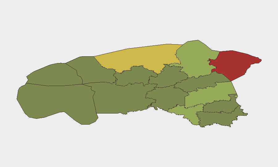
Estonia remains a low-threat environment overall (global rank #134), with no major security incidents documented in the past 24–48 hours. However, sub-national risk concentration in northeastern and central counties—particularly Ida-Viru (78) and Harju (68)—reflects persistent vulnerabilities linked to proximity to Russia, energy infrastructure exposure, and legacy industrial-zone vulnerabilities. The security picture is stable but requires focused monitoring of border-adjacent regions and critical infrastructure.
Key Developments
No clearly time-stamped, high-impact security or civil-unrest incidents have been documented in Estonia in the last 24–48 hours across monitored open-source channels (ERR, regional security outlets, and international risk feeds). Routine legislative, defense-posture, and foreign-policy activities continue at earlier July dates and fall outside the current 24–48-hour reporting window. Organizations should monitor routine NATO air-defense posture updates and ongoing property-acquisition legislation as structural developments, but these do not constitute acute incidents. A flood event (reference ID 1104017) has been tracked in system records; current status and impact area require follow-up confirmation. A Ministry-level policy rejection (2026-07-22) has been noted but lacks sufficient operational detail to assess security or duty-of-care implications from available briefs.
Highest-Risk Areas
Ida-Viru County (risk 78) and Harju County (risk 68)—encompassing the northeastern border zone and the capital region—account for the majority of Estonia's composite risk. Ida-Viru's elevated exposure reflects its proximity to the Russian border, Soviet-era industrial infrastructure, and legacy energy-security dependencies; Harju concentrates political, economic, and cyber-attack surface area as Estonia's administrative and business hub. Tartu County (58) and Valga County (55) present secondary risk corridors along central and southern transit routes. Risk distribution drops sharply in western and southern counties (Pärnu, 35 and below), indicating that duty-of-care focus should prioritize northeastern and capital regions for personnel safety, asset protection, and supply-chain continuity planning.
How GeoBit Would Assist
AOI Monitoring & Early Warning would enable real-time alerting on border-adjacent activity, infrastructure disruptions, or civil developments in Ida-Viru and Harju counties, with custom thresholds for conflict, protest, or cyber-incident signals. Intel Sweep and multi-language OSINT (including Estonian-language sources, Telegram/social monitoring, and regional feeds) would provide 24–48-hour coverage of political, energy, and security announcements not yet visible in English-language media. GIS & Spatial Analysis and Maritime & Aviation tracking would support route planning, supply-chain resilience assessment, and early warning of border or port-area anomalies. For cyber-risk contextualization, Shodan and Network & Actor Analysis capabilities map critical infrastructure and known threat-actor positioning in Estonia's digital landscape.
7-Day Outlook
No acute escalation indicators are present. Risk trajectory remains stable but persistent; monitor for routine NATO posture announcements, Russian hybrid-activity patterns (disinformation, cyber-targeting), and weather/infrastructure events affecting Ida-Viru and Harju. Organizations should confirm status of the recent flood event and maintain standard protocols for border-region and critical-infrastructure monitoring.
Highest-Risk Areas — Ranked
| # | State / Region | Risk |
|---|---|---|
| 1 | Ida-Viru County | 78 |
| 2 | Harju County | 68 |
| 3 | Tartu County | 58 |
| 4 | Valga County | 55 |
| 5 | Lääne-Viru County | 52 |
| 6 | Pärnu County | 35 |
| 7 | Rapla County | 32 |
| 8 | Jõgeva County | 30 |
| 9 | Järva County | 28 |
| 10 | Viljandi County | 25 |
| 11 | Põlva County | 22 |
| 12 | Võru County | 18 |
Previous Daily Briefs
A new Estonia brief is written every day — each with its own risk map and downloadable CSV. Here's the last week; use the calendar to go further back.
📅 Browse every day by calendar →
Highlighted days have a brief. Tap a day for that day's map & analysis, or “csv” for that day's dataset ($5).
Atlas — our AI intelligence desk — emails them this snapshot personally. Nothing else, no list.