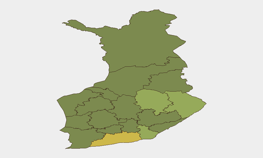
Situation Summary
Finland remains a low-threat environment globally (composite score 2), with no verified major security incidents in the past 24 hours. However, regional risk concentrates heavily in border regions and the greater Helsinki area, driven by drone precautions along the eastern Gulf of Finland (July 28) and ongoing infrastructure investigations. The security posture reflects heightened vigilance rather than acute crisis, with authorities responsive to airspace and maritime risks tied to broader regional drone activity near Russian territory.
Key Developments
- Eastern Gulf of Finland airspace & maritime zone (2026-07-28): Finland's defence forces closed part of the airspace and temporarily restricted maritime traffic as a precautionary measure in response to drone-risk assessment; military stated the closure enabled safe operations should drones stray into Finnish territory from ongoing activity near St Petersburg.
- Infrastructure investigations (dates unspecified, ongoing): The National Bureau of Investigation is actively investigating two separate cable-severing incidents—one in Ylöjärvi (Pirkanmaa) and another in Malmi (Helsinki)—flagging potential deliberate infrastructure disruption requiring corporate asset awareness in those localities.
- Helsinki central-area mobility impact (current): Police have issued active traffic advisories for central Helsinki due to Pride parade scheduling, affecting corporate commute planning and site access in the capital.
Highest-Risk Areas
Uusimaa (Helsinki metropolitan region, risk 65) dominates the national risk profile, reflecting both population density and proximity to critical infrastructure and diplomatic assets. North Karelia, Kymenlaakso, and North Savo (risks 44, 42, 40 respectively) follow, with geographic proximity to the Russian border and eastern Gulf of Finland creating drone and cross-border security sensitivities. The eastern and southeastern regions collectively account for heightened monitoring posture; organizations with personnel or assets in these zones should expect continued airspace advisories and border-zone vigilance through the near term.
How GeoBit Would Assist
AOI Monitoring & Early Warning with persistent watch on the eastern Gulf of Finland, border airspace, and Uusimaa infrastructure corridors would provide real-time alerting on airspace restrictions, maritime closures, and cable/sabotage incidents before they affect supply chains or personnel movement. Intel Sweep paired with OSINT fusion (X/Telegram/multi-language sources) enables rapid corroboration of drone events and infrastructure disruptions, closing the lag between local detection and corporate situational awareness. Routing & Network Analysis would support alternative journey and supply-chain planning when Helsinki central zones or eastern border regions experience restrictions or incidents.
7-Day Outlook
Finland's threat level is expected to remain stable at the national level, with residual drone precautions along the eastern Gulf likely to persist through early August pending broader regional de-escalation. Infrastructure investigations may yield additional incident reports; corporate security teams should anticipate continued advisory updates for eastern regions and periodic airspace/maritime notices rather than acute new crises.
Highest-Risk Areas — Ranked
| # | State / Region | Risk |
|---|---|---|
| 1 | Uusimaa | 65 |
| 2 | North Karelia | 44 |
| 3 | Kymenlaakso | 42 |
| 4 | North Savo | 40 |
| 5 | South Karelia | 38 |
| 6 | Kainuu | 36 |
| 7 | Päijät-Häme | 35 |
| 8 | South Savo | 32 |
| 9 | Kanta-Häme | 30 |
| 10 | Pirkanmaa | 28 |
| 11 | Central Finland | 26 |
| 12 | Southwest Finland | 25 |
Sources
Previous Daily Briefs
A new Finland brief is written every day — each with its own risk map and downloadable CSV. Here's the last week; use the calendar to go further back.
📅 Browse every day by calendar →
Highlighted days have a brief. Tap a day for that day's map & analysis, or “csv” for that day's dataset ($5).
Atlas — our AI intelligence desk — emails them this snapshot personally. Nothing else, no list.