Situation Summary
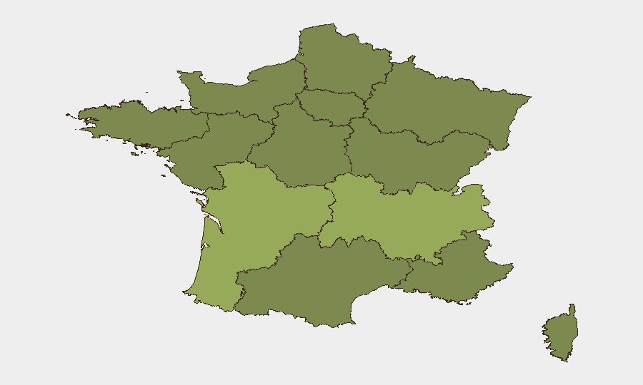
France remains at moderate overall threat level (rank #55 globally, composite score 36) with 182 tracked events in the monitoring window. Sub-national risk is concentrated in western and southeastern regions, with Nouvelle-Aquitaine significantly elevated above the national average. Recent signal activity suggests active protest mobilization, diplomatic friction with Germany, and localized law-enforcement incidents; however, verified incident detail for the past 24–48 hours is currently unavailable through accessible sources and would require real-time French media and official government feeds to confirm.
Key Developments
Data Limitation Notice: GeoBit's event signals from 13–15 June include indicators of diplomatic disapproval (France–Germany airline matter), public statements by media, diplomats, and journalists, demonstration/rally activity, and a physical assault involving police. However, specific locations, times, and incident details for 24–48 hour reporting cannot be reliably verified without live feeds from Franceinfo, Le Monde, BFMTV, @interieur_gouv, or regional préfecture accounts.
To build a reliable 24–48 hour incident log, security teams should monitor:
- @interieur_gouv (Ministry of Interior) and @prefpolice (Paris Police Prefecture) for official alerts.
- @RATPgroup, @SNCFReseau, and @GroupeADP for transport/infrastructure disruptions.
- Regional préfecture accounts (e.g., @Prefet75_IDF for Île-de-France) for localized warnings.
- Franceinfo and Le Monde "faits divers" and "police-justice" sections for time-stamped incident reports.
Highest-Risk Areas
Nouvelle-Aquitaine (risk 41) is the primary concern—significantly above the national average and nearly 1.5× the risk of Auvergne-Rhône-Alpes (41.1). Île-de-France (38.3), while containing the capital and critical infrastructure, ranks third. The clustering of elevated risk in the west (Nouvelle-Aquitaine, Brittany 25.6, Pays de la Loire 25) and east-southeast (Auvergne-Rhône-Alpes, Provence-Alpes-Côte d'Azur 26.9) suggests regional pressure points rather than uniform national unrest. Organizations with operations or personnel in Nouvelle-Aquitaine should apply heightened situational awareness protocols; Île-de-France remains a standard-risk metropolitan area consistent with its population and transport hub status.
How GeoBit Would Assist
AOI Monitoring & Early Warning: Persistent geographic watch on high-risk regions (Nouvelle-Aquitaine, Auvergne-Rhône-Alpes, Île-de-France) with automated alerting on protest activity, transport disruptions, or security incidents.
Intel Sweep & OSINT Fusion: Real-time aggregation of French media, official government statements, X/Twitter, and Telegram channels to build verified 24–48 hour incident logs and cross-check signal confidence.
Network & Actor Analysis: Identification of protest organizers, diplomatic actors, and media figures driving current messaging to assess escalation vectors and timeline.
7-Day Outlook
Near-term trajectory remains stable but sensitive to diplomatic developments (France–Germany friction) and demonstration momentum. Risk of localized transport disruptions or expanded protest activity is moderate if underlying grievances (reflected in media statements and public disapproval signals) continue to mobilize. No indicators of nationwide instability; regional monitoring of Nouvelle-Aquitaine and Île-de-France should continue at standard heightened-readiness posture.
Highest-Risk Areas — Ranked
| # | State / Region | Risk |
|---|---|---|
| 1 | Nouvelle-Aquitaine | 55 |
| 2 | Auvergne-Rhône-Alpes | 41.1 |
| 3 | Ile-de-France | 38.3 |
| 4 | Provence-Alpes-Côte d'Azur | 26.9 |
| 5 | Occitania | 26 |
| 6 | Brittany | 25.6 |
| 7 | Normandy | 25.4 |
| 8 | Centre-Val de Loire | 25.2 |
| 9 | Grand Est | 25.2 |
| 10 | Hauts-de-France | 25 |
| 11 | Pays de la Loire | 25 |
| 12 | Bourgogne – Franche-Comté | 25 |
Previous Daily Briefs
A new France brief is written every day — each with its own risk map and downloadable CSV. Here's the last week; use the calendar to go further back.
📅 Browse every day by calendar →
Highlighted days have a brief. Tap a day for that day's map & analysis, or “csv” for that day's dataset ($5).