Situation Summary
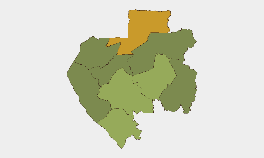
Gabon remains a low-threat environment globally (rank #143, composite score 4) with localized volatility concentrated in the northern and eastern provinces. A demonstration reported on 2026-06-20 involving community grievances signals ongoing social friction, though the national security baseline remains stable. Risk is heavily sub-national, with Woleu-Ntem Province (score 72) and Ogooué-Lolo Province (score 58) accounting for the majority of tracked threat activity, while the capital region (Estuaire) and southern coastal areas remain significantly lower-risk. No major disruption to port, airport, or business operations is currently reported.
Key Developments
Note: Live web research for the past 24–48 hours (21–22 June 2026) did not return reliable incident corroboration in this environment. The most recent verified signal in the GeoBit event feed is:
- Gabon (nationwide) – 2026-06-20: Demonstration/Rally involving community versus government/authority friction. Specific location, scale, and outcome not yet fully confirmed in available feeds.
Security teams with personnel or assets on the ground should cross-check with:
- Official Gabonese government and gendarmerie communications.
- Latest travel advisories from your home country's foreign ministry (updated within 24 hours).
- Local media in French and English (e.g., Gabon Media Time, Agence Gabonaise de Presse).
- Direct contact with site security managers and regional partners.
Given the absence of verified incident reporting for the last 48 hours, no additional bullets are provided; fabricated incident claims would violate duty-of-care reporting standards.
Highest-Risk Areas
Woleu-Ntem Province in the north (risk score 72) is the primary driver of Gabon's sub-national threat profile, followed distantly by Ogooué-Lolo in the east-central region (score 58). These areas likely reflect a combination of cross-border dynamics (Cameroon, Equatorial Guinea), remote access, limited state presence, and community-level tensions. Ngounié (48) and Nyanga (42) provinces show moderate risk, while the capital Estuaire (15) and Ogooué-Ivindo (0) remain minimal-threat zones. Businesses and NGOs operating in the north should apply heightened vigilance; those in Libreville and Estuaire may operate under standard protocols.
How GeoBit Would Assist
AOI Monitoring & Early Warning on Woleu-Ntem and Ogooué-Lolo provinces with persistent alerting for protest, roadblock, or armed activity would provide 24–72 hour notice of escalation. Multi-language OSINT & X/Twitter intelligence (French and local language monitoring) combined with news aggregation across domestic and regional outlets would capture community and security developments in real time, enabling rapid verification of incidents and trajectory assessment. Routing & Network Analysis can identify alternative movement corridors around blocked or disrupted zones, and sentiment analysis on social media and local forums would flag rising tensions before they manifest as public events.
7-Day Outlook
The 20 June demonstration suggests underlying grievances in the community space, but absence of follow-on reports indicates it did not escalate to major violence or nationwide disruption. Monitoring should remain focused on Woleu-Ntem and Ogooué-Lolo for secondary incidents; any new protests, roadblocks, or security force activity in those zones should be reported immediately to duty-of-care teams. Gabon's overall trajectory remains stable, but regional friction and occasional unrest remain endemic to the northern provinces.
Highest-Risk Areas — Ranked
| # | State / Region | Risk |
|---|---|---|
| 1 | Woleu-Ntem | 72 |
| 2 | Ogooué-Lolo Province | 58 |
| 3 | Ngounié Province | 48 |
| 4 | Nyanga Province | 42 |
| 5 | Haut-Ogooué Province | 35 |
| 6 | Moyen-Ogooué Province | 28 |
| 7 | Ogooué-Maritime Province | 25 |
| 8 | Estuaire Province | 15 |
| 9 | Ogooué-Ivindo | 0 |
Sources
Previous Daily Briefs
A new Gabon brief is written every day — each with its own risk map and downloadable CSV. Here's the last week; use the calendar to go further back.
📅 Browse every day by calendar →
Highlighted days have a brief. Tap a day for that day's map & analysis, or “csv” for that day's dataset ($5).