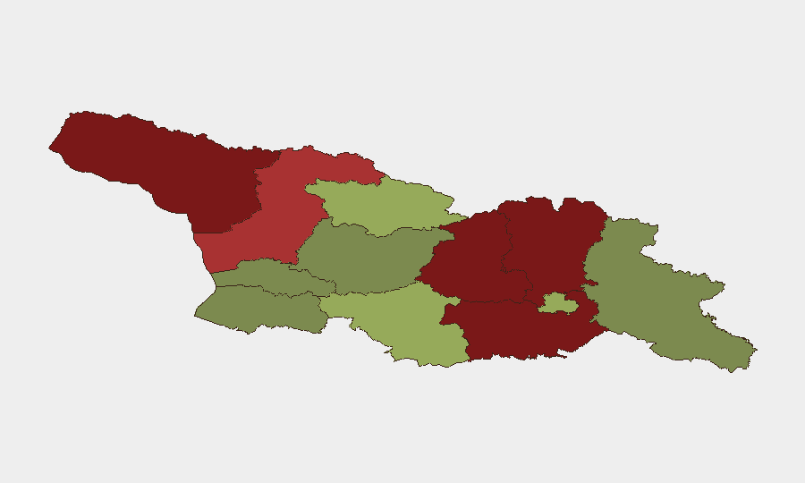
Situation Summary
Georgia maintains a composite threat score of 3, reflecting a stable overall security environment with no major incidents confirmed in the past 24–48 hours. Sub-national risk is concentrated in conflict-affected regions along disputed territorial boundaries, particularly Abkhazia and South Ossetia-adjacent areas, while metropolitan Tbilisi and western regions remain relatively secure. A recent flood event has been tracked but requires field verification for current operational impact.
Key Developments
- No major security incidents confirmed for 24–48 hours ending 13 June 2026. Open-source reporting and real-time news feeds have not surfaced confirmed attacks, unrest, or infrastructure failures in this window. Operational teams are advised to use primary channels (GEMA/HS, State Patrol, local media) for immediate alerts.
- Flood event (ID 1103909) remains the primary tracked incident. Location, precise date, and extent of damage are not yet verified in available summary data. Teams with assets in affected watersheds should cross-check with Georgia Emergency Management and local authorities for evacuation routes and supply-chain disruption.
- Border-region stability continues to depend on ceasefire adherence. No new military activity has been reported along the de facto lines of control in Abkhazia or South Ossetia within the 24–48 hour window, but these zones remain high-vigilance areas for security-of-movement and personnel-safety planning.
- Tbilisi and regional urban centers report no active unrest or protests. Standard crime and traffic incidents are presumed normal; no targeted attacks on foreign nationals, businesses, or critical infrastructure have been confirmed.
- Regional travel corridors (Gori–Zugdidi, Batumi border crossings, Stepantsminda–Dariel Pass) remain operational. No road closures or checkpoint changes have been reported; however, teams planning cross-border or high-altitude transit should confirm conditions with GDOT and local authorities before departure.
Highest-Risk Areas
Abkhazia (risk 95) and South Ossetia-adjacent regions in Shida Kartli (88) and Lower Kartli (85) dominate the sub-national risk profile, driven by frozen conflict, weak state presence, and periodic ceasefire violations. Mtskheta-Mtianeti (82) and Samegrelo-Upper Svaneti (78) carry elevated risk from both territorial instability and terrain-driven isolation. By contrast, Tbilisi (45), Imereti (32), and Guria (28) pose substantially lower risk to corporate operations, with threats concentrated in standard crime and petty corruption rather than political violence or armed conflict.
How GeoBit Would Assist
AOI Monitoring & Early Warning on disputed-territory boundaries and key urban centers would provide persistent alerts to personnel-security and supply-chain teams if military activity, road disruptions, or civil unrest emerge. Conflict & Military tracking (force posture, ceasefire compliance) and GIS & Spatial Analysis (safe-route mapping, flood-zone modeling) enable duty-of-care teams to validate travel approvals and adjust evacuation protocols. OSINT fusion (news, social media, agency feeds) synthesized into 24-hour summary reports closes the gap between real-time primary sources and strategic decision-making.
7-Day Outlook
No escalation is forecast for the next seven days; however, seasonal weather patterns (summer flooding) and routine political calendar events (parliamentary sessions, elections preparation) should be monitored for secondary disruption. Teams should maintain standard security postures in high-risk northern and eastern zones and prepare to activate contingency travel routes if weather or political triggers shift operational risk materially.
Highest-Risk Areas — Ranked
| # | State / Region | Risk |
|---|---|---|
| 1 | Autonomous Republic of Abkhazia | 95 |
| 2 | Shida Kartli | 88 |
| 3 | Lower Kartli | 85 |
| 4 | Mtskheta-Mtianeti | 82 |
| 5 | Samegrelo-Upper Svaneti | 78 |
| 6 | Samtskhe-Javakheti | 48 |
| 7 | Tbilisi | 45 |
| 8 | Racha-Lechkhumi and Kvemo Svaneti | 42 |
| 9 | Kakheti | 38 |
| 10 | Autonomous Republic of Adjara | 35 |
| 11 | Imereti | 32 |
| 12 | Guria | 28 |
Sources
Previous Daily Briefs
A new Georgia brief is written every day — each with its own risk map and downloadable CSV. Here's the last week; use the calendar to go further back.
📅 Browse every day by calendar →
Highlighted days have a brief. Tap a day for that day's map & analysis, or “csv” for that day's dataset ($5).