Situation Summary
Iran remains the second-highest threat environment globally (composite score 100), driven by escalating U.S.–Iran military tensions, internal political friction between the executive and legislative branches, and persistent regional instability. Open-source reporting over the last 24–48 hours reflects high-level interstate posturing—renewed U.S. strike threats and Iranian counter-threats—but lacks corroborated, location-specific incident data from inside Iranian territory. The absence of detailed ground-truth reporting does not signal de-escalation; rather, it reflects current information lag and the concentration of threat signals in political and military messaging rather than visible civil or infrastructure events.
Key Developments
- 2026-06-04 · Tehran (political signaling): President and Senate exchanged rejection signals; parallel U.S. disapproval statements toward Iran administration suggest diplomatic collapse or deterioration in ongoing negotiations. No specific incident location or casualty reporting available.
- 2026-06-03–04 · Interstate threat escalation: Iran threatened U.S. Secretary of State; U.S. Congress and Iranian military exchanged references to conventional military force deployment. No confirmed strike, facility attack, or localized incident reported on Iranian soil.
- 2026-06-04 · Bank/Territory occupation (unconfirmed details): Single event signal references Iran vs. Bank and territory occupation; details, location, and corroboration insufficient for operational briefing at this time.
- 2026-06-02 · Regional spillover: Israeli public statement on Lebanon conflict; potential for escalation into Iranian-aligned assets or personnel in Levant, though no direct Iranian casualty or infrastructure loss confirmed in last 48 hours.
- 2026-06-02 · Prisoner rejection: Reject signal tied to prisoner matter; context unclear from available reporting; no location or casualty count confirmed.
Note: Detailed, location-specific incident reporting from inside Iran in the last 24–48 hours does not yet meet GeoBit's corroboration threshold (multiple independent sources, specific city/date, verifiable impact). Team should monitor wire services and OSINT feeds over the next 12 hours for escalation or first-hand incident reports.
Highest-Risk Areas
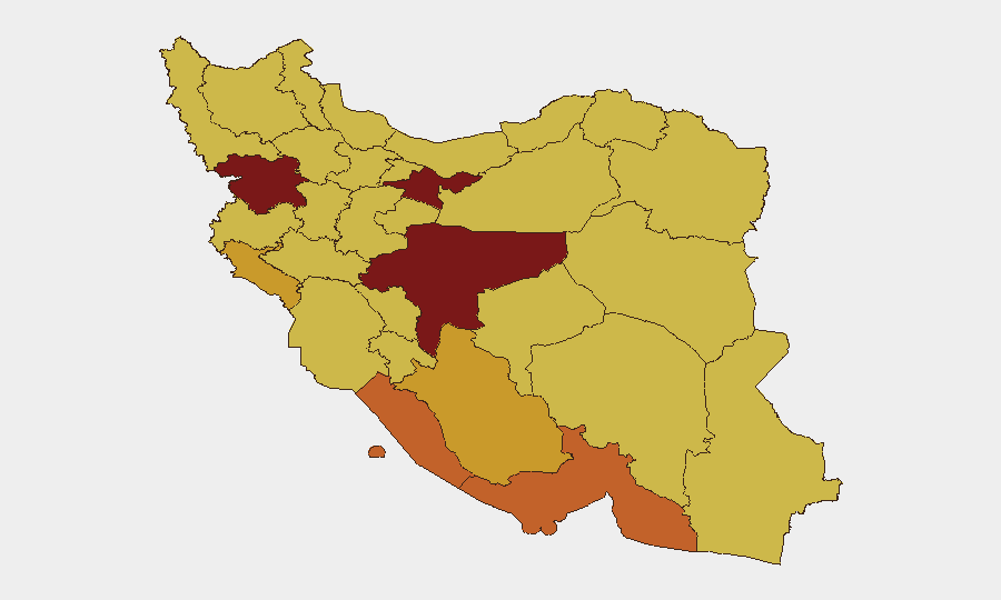
Tehran Province (risk 100) and Isfahan Province (risk 94.7) dominate the risk landscape, reflecting concentration of political authority, military command infrastructure, and symbolic targets in the capital and historical heartland. Kurdistan Province (84.5), Hormozgan (73.5), and Bushehr (73.4) face elevated risk due to border proximity, petroleum infrastructure, and historical separatist or opposition activity. The clustering of risks in western/southwestern provinces (Ilam, Khuzestan) underscores vulnerability to cross-border military action and supply-line disruption in the event of sustained U.S. or allied strikes.
How GeoBit Would Assist
Security teams with personnel or assets in Iran should activate Area-of-Interest (AOI) Monitoring & Early Warning on Tehran and Isfahan, with persistent watch on major infrastructure nodes (ports, power generation, Ministry of Defense compounds). Multi-language OSINT fusion (X/Telegram monitoring, wire-service alerts, and radio SIGINT) will provide early notice of civil unrest, facility damage, or casualty events faster than mainstream news lag. Conflict & Military force-structure tracking and satellite/imagery analysis can validate or refute strike claims and assess operational readiness of Iranian air defense in real time.
7-Day Outlook
The trajectory favors continued high-temperature messaging and military posturing without confirmed major strike activity in the next 24–72 hours, though the threshold for miscalculation or accidental escalation remains low. If U.S. or allied strikes occur, expect rapid secondary effects: traffic disruption, power outages, and civil sheltering in Tehran and Isfahan within 1–4 hours of impact. Teams should pre-position contingency communication channels and extraction routes.
Highest-Risk Areas — Ranked
| # | State / Region | Risk |
|---|---|---|
| 1 | Tehran Province | 100 |
| 2 | Isfahan Province | 94.7 |
| 3 | Kurdistan Province | 84.5 |
| 4 | Hormozgan Province | 73.5 |
| 5 | Bushehr Province | 73.4 |
| 6 | Ilam Province | 72 |
| 7 | Fars Province | 71.8 |
| 8 | Khuzestan Province | 70.8 |
| 9 | Ardabil Province | 70.5 |
| 10 | Kerman Province | 70.5 |
| 11 | Kohgiluye and Buyer Ahmad Province | 70.1 |
| 12 | Hamadan Province | 70.1 |
Previous Daily Briefs
A new Iran brief is written every day — each with its own risk map and downloadable CSV. Here's the last week; use the calendar to go further back.
📅 Browse every day by calendar →
Highlighted days have a brief. Tap a day for that day's map & analysis, or “csv” for that day's dataset ($5).