Situation Summary
Israel remains engaged in active conventional military operations on multiple fronts—northern border exchanges with Hezbollah and Syrian forces, ongoing ground operations in Gaza, and reported Iranian military activity—with the composite threat score at 99.7 (rank #12 globally). The past 48 hours show sustained cross-border fire, IDF response strikes, and continued urban/tunnel clearance operations in southern Gaza. Risk trajectory remains high across the South, Tel Aviv, North, and Central districts; no material de-escalation indicators are present in current signals.
Key Developments
- Northern border (Metulla, Upper Galilee) – June 5: Multiple Hezbollah anti-tank missile and rocket launches from southern Lebanon triggered IDF airstrikes on identified launch sites and infrastructure; concurrent Red Alert warnings recorded in northern Israeli communities.
- Western Galilee & Golan area – June 5: Cross-border fire from Lebanon into Israeli communities met with Israeli artillery and airstrikes on firing positions in southern Lebanon, with multiple Red Alert sirens logged in real time across northern communities.
- Khan Yunis, Gaza – June 5: IDF ground forces continued search-and-clearance operations, reporting engagement of armed militants, discovery of weapons caches, and tunnel infrastructure during raids.
- Zaytun neighborhood, Gaza City – June 5: IDF forces engaged armed cells in urban operations, locating weapons and tunnel infrastructure; small-arms fire and drone strikes reported throughout the 24-hour period.
- Gaza envelope communities – June 5: Rocket and projectile launches from Gaza toward Israeli border communities triggered Red Alerts and sheltering; Israeli retaliatory strikes on identified launch sites.
- Iran military activity – June 4: Reported conventional military force activity by Iran toward Israel, coupled with June 5 threats; source and scale require continued monitoring.
- U.S. diplomatic signals – June 4: Israeli disapproval of U.S. position and June 5 statements by U.S. President indicate diplomatic friction alongside active conflict.
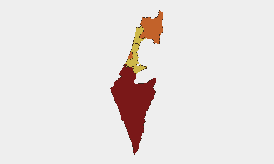
Highest-Risk Areas
The South District (99.8) dominates the risk landscape, driven by active ground operations in Gaza and ongoing rocket fire from the Strip toward the Israeli envelope. The North District (73.2) and Tel Aviv District (73.7) follow, reflecting sustained Hezbollah cross-border fire, IDF response operations, and the proximity of civilian populations to active fire zones. Jerusalem, Haifa, and Center districts remain elevated (69.8–69.9) due to secondary effects, broader conflict spillover risk, and potential for escalation. U.S. State Department travel restrictions within 4 km of Lebanon/Syria borders and 11.3 km of Gaza demarcation underline the operational severity in these zones.
How GeoBit Would Assist
Corporate security teams should deploy AOI (Area of Interest) Monitoring & Early Warning on facilities and personnel locations in high-risk districts, with real-time alerting on Red Alert siren activity, fire exchanges, and IDF operational updates. Battle Mapping and GIS & Spatial Analysis capabilities enable duty-of-care teams to visualize restricted zones, alternative routing, and safe perimeters for personnel movement. OSINT Fusion (X/Twitter, Telegram, IDF feeds, conflict-monitoring accounts) combined with Conflict & Military tracking provides 24-hour situational updates on force movements, weapons activity, and escalation signals that inform evacuation or sheltering decisions.
7-Day Outlook
Cross-border fire and ground operations are expected to persist at current intensity or escalate if Iranian military activity materializes at scale or if Hezbollah sustains rocket barrages. Gaza operations remain active; no ceasefire negotiations are signaled in current public statements. Risk to business continuity, personnel safety, and asset security in the South and North districts will remain critical for the next 7 days; operational planning should assume no material reduction in threat posture.
Highest-Risk Areas — Ranked
| # | State / Region | Risk |
|---|---|---|
| 1 | South District | 99.8 |
| 2 | Tel-Aviv District | 73.7 |
| 3 | North District | 73.2 |
| 4 | Center District | 69.9 |
| 5 | Haifa District | 69.8 |
| 6 | Jerusalem District | 69.8 |
Previous Daily Briefs
A new Israel brief is written every day — each with its own risk map and downloadable CSV. Here's the last week; use the calendar to go further back.
📅 Browse every day by calendar →
Highlighted days have a brief. Tap a day for that day's map & analysis, or “csv” for that day's dataset ($5).