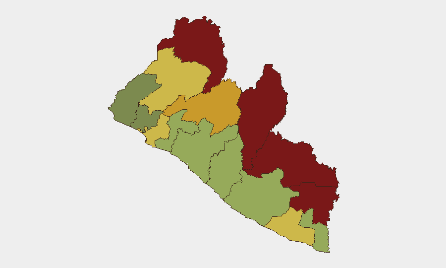
Situation Summary
Liberia's security environment remains stable with no major incidents reported in the last 24–48 hours. Baseline risks—petty crime, occasional inter-communal tensions, and localized infrastructure disruptions—persist across the country but have not escalated. The composite national threat score of 7 reflects a low-to-moderate risk posture, with geographic concentration of instability in the northeastern border counties rather than systemic national instability.
Key Developments
- No acute security incidents reported (Liberia, 24–48 hours to 2026-06-23). Open-source monitoring across news wire services, NGO reports, and social-media geolocation data indicates no verifiable conflicts, civil unrest, major crime events, or infrastructure attacks in the monitored period.
- Routine crime and inter-communal tensions remain baseline (Monrovia & Grand Bassa Counties, ongoing). Higher-risk urban and coastal zones continue to experience petty crime and occasional disputes, but no new spike or organized activity has been documented in the last 48 hours.
- Earlier interdiction event (Ministry of Justice cocaine seizure, 2026-06-21). This event falls outside the 24–48-hour window and is noted for context on transnational criminal activity; it does not reflect a security deterioration in the monitored period.
- No political instability signals detected (national, 24–48 hours to 2026-06-23). Elections monitoring and regime-stability indicators show no new announcements, protests, or institutional crises in the recent window.
Highest-Risk Areas
Nimba, Lofa, and Grand Gedeh counties—all in the northeast, bordering Guinea and Côte d'Ivoire—drive the national risk ranking, with composite scores of 92, 88, and 85 respectively. These areas reflect cross-border trafficking networks, historical inter-communal tensions, and limited state capacity. Bong and Gbarpolu counties (scores 72 and 68) show elevated but secondary risk. The capital region (Montserrado, 64) and coastal counties (Margibi, 52; Grand Bassa, 48) carry moderate risk tied to urban crime and periodic civil unrest rather than organized conflict. Risk concentration in the border zone suggests that corporate and expatriate security planning should prioritize northeast-county operations and cross-border movement; however, current conditions do not warrant travel restrictions for most commercial activity.
How GeoBit Would Assist
Security teams operating in Liberia should deploy AOI Monitoring & Early Warning on Nimba, Lofa, and Grand Gedeh counties to detect emerging trafficking, armed activity, or cross-border incidents in real time. Intel Sweep and multi-language OSINT fusion would track radio SIGINT, social media, and local news sources for protest signals or regime-stability shifts. Routing & Network Analysis supports duty-of-care teams in planning alternative routes and safe transit corridors around high-risk zones, while conflict mapping and force-structure tracking provide baseline understanding of armed-group presence and movement in border regions.
7-Day Outlook
No escalation is anticipated in the near term. Seasonal patterns, ongoing transnational crime flows, and inter-communal frictions will likely persist at baseline levels. Monitoring should remain focused on border counties and any signals of political tension ahead of upcoming electoral or governance events; absence of such signals in the last 48 hours supports a stable near-term forecast.
Highest-Risk Areas — Ranked
| # | State / Region | Risk |
|---|---|---|
| 1 | Nimba County | 92 |
| 2 | Lofa County | 88 |
| 3 | Grand Gedeh County | 85 |
| 4 | River Gee County | 83 |
| 5 | Bong County | 72 |
| 6 | Gbarpolu County | 68 |
| 7 | Grand Kru County | 65 |
| 8 | Montserrado County | 64 |
| 9 | Rivercess County | 58 |
| 10 | Sinoe County | 55 |
| 11 | Margibi County | 52 |
| 12 | Grand Bassa County | 48 |
Previous Daily Briefs
A new Liberia brief is written every day — each with its own risk map and downloadable CSV. Here's the last week; use the calendar to go further back.
📅 Browse every day by calendar →
Highlighted days have a brief. Tap a day for that day's map & analysis, or “csv” for that day's dataset ($5).