Situation Summary
Malta remains a low-threat jurisdiction globally (rank #168, composite score 4.0) with no tracked discrete security events in the current reporting window. However, localised public-order incidents—petty vandalism, disorderly conduct, and minor fire response—have emerged in the past 24–48 hours, primarily concentrated in high-density tourist and residential zones. The incidents reflect seasonal patterns of transient populations and rowdy visitor behaviour rather than organized threats or systemic instability.
Key Developments
- Ħaż-Żabbar (12–13 July, early hours): Civil Protection Malta responded to a rubbish fire and contained it without escalation or injuries.
- Swieqi (last 24–48 hours): Police opened an investigation after youths were filmed shouting and throwing drink containers from balconies over a residential street, raising public-order and endangerment concerns.
- St Julian's, Triq Luigi Apap (recent, last 24–48 hours): Residents reported a break-in by a group who forced entry, damaged doors and common areas, and caused significant disturbance; building security and resident safety now under review.
- Mellieħa, db Seabank Hotel (last 24–48 hours): Online footage shows tourists throwing bottles from a balcony; hotel management has introduced new security measures in response to this incident and a prior violent poolside brawl.
- St Julian's, Triq Luigi Apap pool area (incident last weekend; response reported last 24–48 hours): A violent poolside altercation involving rowdy guests prompted staff inadequacy concerns; the property has since announced tightened pool-area supervision and security protocols.
- Nationwide tourism areas (social media, last 24–48 hours): Travel content from visitors notes crowded nightlife and occasional disruptive behaviour but reports no targeted attacks, organized crime, or major security breaches; primary risks remain petty disorder and minor fires.
Highest-Risk Areas
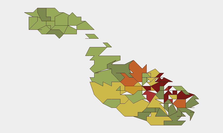
Valletta, Sliema, and Saint Julian's (composite risk scores 95, 92, and 90 respectively) represent Malta's highest-risk sub-national zones, reflecting dense tourist footfall, high-capacity nightlife venues, and mixed residential–commercial populations vulnerable to transient disorderly conduct and petty crime. Gżira, Hamrun, and Paola (scores 88, 87, 86) follow closely, driven by similar density and socioeconomic mixing. Recent incidents cluster in Saint Julian's and outlying zones, correlating with seasonal tourism surge and poolside/nightlife settings where alcohol-fuelled rowdiness has triggered police and property-management responses. Risk is episodic and behaviour-driven rather than structural.
How GeoBit Would Assist
Corporate security teams with personnel or assets in Malta can deploy AOI (Area-of-Interest) Monitoring & Early Warning on high-risk zones (Valletta, Sliema, Saint Julian's) to track emerging public-order patterns and alert on escalation signals in real time. Intel Sweep and multi-language OSINT across social media and local news feeds provide continuous visibility of disorderly incidents, fire events, and resident complaints before they reach formal reporting channels, enabling duty-of-care escalation and relocation decisions. Risk & Threat Assessment products synthesize sub-national rankings and incident data to support security policy, venue selection, and residency-risk reviews for staff assignments.
7-Day Outlook
Public-order incidents are expected to remain low-frequency and episodic, concentrated in high-density tourist and nightlife clusters during peak summer season. No escalation to organized crime, political unrest, or systemic security breakdown is indicated. Standard vigilance on crowded venues, residential-block entry control, and liaison with local police on incident reporting remains the primary mitigation stance.
Highest-Risk Areas — Ranked
| # | State / Region | Risk |
|---|---|---|
| 1 | Valletta | 95 |
| 2 | Sliema | 92 |
| 3 | Saint Julian's | 90 |
| 4 | Gżira | 88 |
| 5 | Hamrun | 87 |
| 6 | Paola | 86 |
| 7 | Msida | 85 |
| 8 | Birkirkara | 84 |
| 9 | Birgu | 83 |
| 10 | Senglea | 82 |
| 11 | Cospicua | 81 |
| 12 | Żabbar | 80 |
Sources
Previous Daily Briefs
A new Malta brief is written every day — each with its own risk map and downloadable CSV. Here's the last week; use the calendar to go further back.
📅 Browse every day by calendar →
Highlighted days have a brief. Tap a day for that day's map & analysis, or “csv” for that day's dataset ($5).
Atlas — our AI intelligence desk — emails them this snapshot personally. Nothing else, no list.