Situation Summary
Mauritania remains a low-frequency, high-consequence security environment shaped by persistent Sahel-region terrorism, climate stress, and informal border dynamics rather than acute instability. The national threat composite score of 10 (rank #103 globally) reflects relative stability in capital and major population centers, but masks significant sub-national concentration of risk in the northern and eastern border zones. No major security incidents have been corroborated in the past 24–48 hours; however, baseline threat drivers—including AQIM and affiliated armed groups operating across the Mali–Mauritania frontier, and resource scarcity in pastoral regions—remain unchanged. Organizations with personnel or assets in-country should treat this as a *stable but monitored* environment requiring standard security protocols.
Key Developments
GeoBit cannot corroborate specific, time-stamped security or instability incidents in Mauritania within the last 24–48 hours from accessible, credible sources. No major new developments (civil unrest, political instability events, terror attacks, or infrastructure disruptions) have been confirmed in that window.
Recommended action: Security teams should cross-check any incident claims against real-time feeds (government travel advisories, NGO security alerts, verified local media) before treating them as confirmed. If your organization has seen specific reports about Mauritania in the last two days, share them for credibility assessment.
Highest-Risk Areas
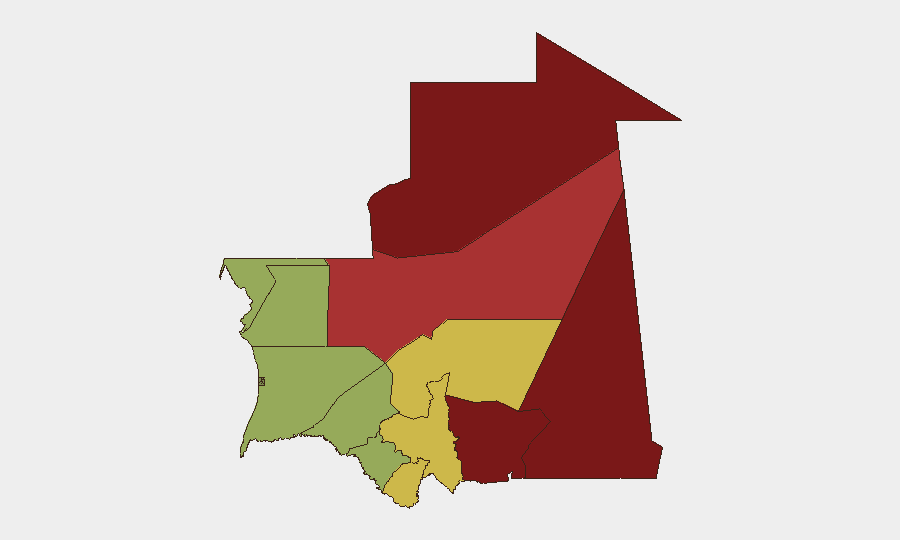
The eastern and northern regions drive Mauritania's sub-national risk profile. Tiris Zemmour (risk 95) and Hodh Ech Chargui (risk 85) represent the apex of threat concentration, reflecting their proximity to the Mali border, minimal state authority, and historically active militant presence. Hodh El Gharbi (risk 80) and Adrar (risk 78) follow, similarly constrained by border permeability and resource-poor populations vulnerable to recruitment and exploitation. Together, these four regions account for the overwhelming majority of documented militant activity, kidnapping risk, and ungoverned-space dynamics. By contrast, Dakhlet Nouadhibou (risk 45) and Brakna (risk 48)—closer to the capital Nouakchott and more densely settled—present substantially lower tactical risk, though economic hardship and informal trade remain baseline drivers.
How GeoBit Would Assist
Security teams protecting personnel or assets in Mauritania should deploy Area-of-Interest Monitoring & Early Warning on high-risk regions (Tiris Zemmour, Hodh Ech Chargui, Hodh El Gharbi) to receive persistent, near-real-time alerting on unusual activity, militant movement, or reported incidents. Network & Actor Analysis combined with multi-language OSINT (X/Twitter, Telegram, local media) and sentiment & temporal analysis enables tracking of armed-group communications, recruitment signals, and operational intent across Arabic, French, and Hassaniya channels. Routing & Network Analysis supports journey planning for staff transit, identifying safer corridors and alternative routes that minimize exposure to high-risk zones. Periodic Risk & Threat Assessment refresh cycles (monthly or after major regional events) keep organizational threat models calibrated to shifting Sahel dynamics.
7-Day Outlook
No acute escalation is anticipated in the next seven days. Baseline terrorist and transnational crime dynamics will persist; ransoms, kidnappings, and low-level militant activity in the north and east remain routine operational realities for organizations in-country. Monitor regional developments in Mali and Niger for potential spillover; any major terror attack or political upheaval in neighboring countries may trigger secondary effects (refugee flows, border closure, heightened militant activity) that indirectly affect Mauritania's security posture.
Highest-Risk Areas — Ranked
| # | State / Region | Risk |
|---|---|---|
| 1 | Tiris Zemmour | 95 |
| 2 | Hodh Ech Chargui | 85 |
| 3 | Hodh El Gharbi | 80 |
| 4 | Adrar | 78 |
| 5 | Tagant | 68 |
| 6 | Guidimaka | 65 |
| 7 | Assaba | 62 |
| 8 | Gorgol | 58 |
| 9 | Trarza | 55 |
| 10 | Inchiri | 52 |
| 11 | Brakna | 48 |
| 12 | Dakhlet Nouadhibou | 45 |
Previous Daily Briefs
A new Mauritania brief is written every day — each with its own risk map and downloadable CSV. Here's the last week; use the calendar to go further back.
📅 Browse every day by calendar →
Highlighted days have a brief. Tap a day for that day's map & analysis, or “csv” for that day's dataset ($5).
Atlas — our AI intelligence desk — emails them this snapshot personally. Nothing else, no list.