Situation Summary
Myanmar remains in a state of active armed conflict following the February 2021 military coup, with fragmented control across regions and persistent clashes between the Tatmadaw (armed forces) and various resistance and ethnic armed organizations (EAOs). The composite threat score of 76.7 reflects widespread military strikes as the primary driver; 15 tracked events underscore sustained violence and instability. The security environment is regionally heterogeneous, with Yangon and Shan State presenting acute risks, while structural constraints—internet shutdowns, arbitrary detention, and administrative sanctions—compound operational and reputational risk for organizations with staff or assets in-country.
Key Developments
GeoBit's event-tracking system has identified signals consistent with administrative enforcement and detention activity as of 2 June–4 June 2026 (arrests/detentions, administrative sanctions, and inter-state diplomatic disapproval involving Cambodia); however, no specific, time-stamped incident reports for the last 24–48 hours—such as clashes, airstrikes, bombings, or localized security events—are reliably confirmed from accessible open sources at this time. A magnitude 4.4 seismic event was recorded approximately 52 km northwest of Monywa (Sagaing Region) in recent days, with no reported secondary security or infrastructure impacts confirmed.
To obtain actionable 24–48-hour incident bulletins (location, time, nature of event), security teams should monitor real-time conflict-mapping platforms, wire-service Myanmar desks, and verified Myanmar conflict journalist accounts on X/Twitter, cross-referenced against NGO and news reports before operational use.
Highest-Risk Areas
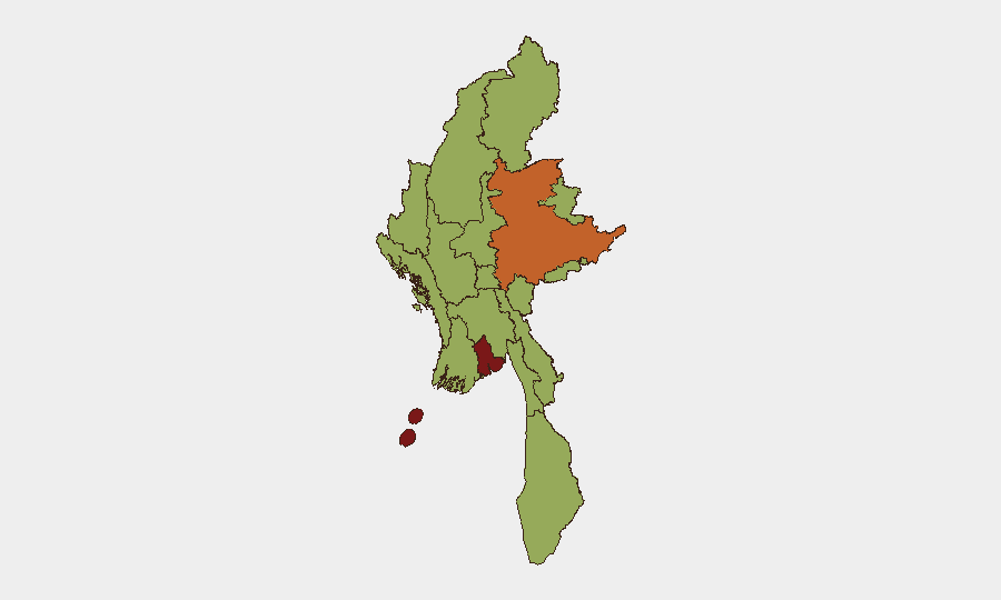
Yangon (83.7) and Shan State (74.7) stand significantly above the secondary tier. Yangon—the country's largest city and commercial hub—faces compounded risk from urban protest and resistance activity, military sweeps, and the concentration of foreign nationals and multinational operations; Shan State's elevation reflects ongoing clashes between multiple armed factions and Thai border-region volatility. A broad secondary band (Tanintharyi, Chin, Sagaing, Kachin, Wa State, Magway, Mandalay, Rakhine, Ayeyarwady, and Naypyitaw) clusters at 53.7, indicating endemic instability across rural and ethnic-minority areas but lower absolute threat density than the capital and northeast. Risk concentration in Yangon and Shan reflects both operational intensity and the presence of critical infrastructure and population centers.
How GeoBit Would Assist
Security teams should deploy AOI (Area-of-Interest) Monitoring & Early Warning on high-risk locations (Yangon divisions, Shan townships with known EAO activity, and staff work/residence zones) to receive automated alerts on conflict events, military activity, or administrative enforcement. Conflict & Military mapping (force structure, weapons-capability tracking) and Network & Actor Analysis enable teams to understand which armed groups control or contest specific areas and forecast friction points. Routing & Network Analysis supports alternative journey planning and safe-corridor identification for staff movements, mitigating exposure to active violence zones.
7-Day Outlook
No major tactical or political shift is expected in the next seven days; the conflict is likely to remain regionally fractured and low-to-moderate intensity in most populated areas. Yangon and Shan State will remain elevated-risk zones. Organizations should maintain heightened duty-of-care protocols, sustain real-time event monitoring via conflict-mapping and news sources, and regularly refresh staff movement authorization and evacuation contingencies.
Highest-Risk Areas — Ranked
| # | State / Region | Risk |
|---|---|---|
| 1 | Yangon | 83.7 |
| 2 | Shan State | 74.7 |
| 3 | Tanintharyi Region | 53.7 |
| 4 | Chin | 53.7 |
| 5 | Sagaing Region | 53.7 |
| 6 | Kachin State | 53.7 |
| 7 | Wa State (Northern Region) | 53.7 |
| 8 | Magway | 53.7 |
| 9 | Mandalay | 53.7 |
| 10 | Rakhine | 53.7 |
| 11 | Ayeyarwady | 53.7 |
| 12 | Naypyitaw Union Territory | 53.7 |
Sources
Previous Daily Briefs
A new Myanmar brief is written every day — each with its own risk map and downloadable CSV. Here's the last week; use the calendar to go further back.
📅 Browse every day by calendar →
Highlighted days have a brief. Tap a day for that day's map & analysis, or “csv” for that day's dataset ($5).