Situation Summary
Niger maintains a composite threat score of 66.7 (global rank #30) with five tracked events as of 11 June 2026. The country faces persistent instability driven primarily by militant activity in the Sahel, though recent 24–48-hour incident reporting from within Niger's borders remains limited in open-source corroboration. Regional dynamics, particularly spillover from Mali and Burkina Faso, continue to influence threat trajectories across northern and eastern zones. Overall threat posture remains elevated but not acute on the basis of current available intelligence.
Key Developments
Recent open-source event signals indicate domestic political activity rather than security incidents:
- 11 June, Niamey (likely) – Public statement and demand activity involving Senate and Nigerian/Nigerien nationals, nature and consequence not yet clarified by independent sources.
- 11 June, National – Public statement and alleged intelligence-related incident involving Nigerian nationals; corroboration and geographic specificity pending.
- 10 June, National – Police-related public statement and arrest/detention activity; details insufficient for specific geographic attribution.
- 8–10 June, National – Series of public statements involving African, Christian, and Nigerian entities with disapproval and rejection signals; underlying incidents not independently confirmed.
Note: Web research conducted over the last 24 hours has not identified independently corroborated security or instability incidents *specifically* located within Niger's borders in the last 48 hours. Most "Niger" reporting in current feeds refers to Niger State, Nigeria, where bandit and terrorist activity has been documented. Older background on the 2023 coup and ongoing Sahel insurgency remains relevant context but does not constitute new developments.
Highest-Risk Areas
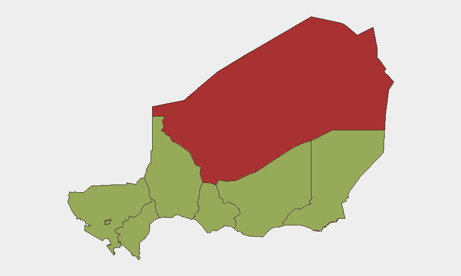
Agadez Region (risk score 76.7) stands as Niger's single highest-threat zone, driven by militant presence, trafficking networks, and cross-border infiltration from Mali and Libya. Zinder, Diffa, Tillabéri, Tahoua, Dosso, and Maradi Regions cluster at 46.7, indicating sustained but lower-intensity risk. Niamey (46.7) reflects political instability and urban crime. The concentration of risk in Agadez reflects its geographic isolation, porous borders, and status as a known transit corridor for Sahel-based insurgent groups (JNIM, ISIS-affiliated cells) and criminal networks. Eastern and northern regions remain vulnerable to spillover from conflict in Mali and Nigeria's northeast.
How GeoBit Would Assist
Security teams with operations or personnel in Niger should employ AOI Monitoring & Early Warning on Agadez, Diffa, and Tillabéri to detect militant movement and cross-border incursions in near-real-time. OSINT Fusion & Corroboration across multi-language feeds, social media (X/Telegram), and radio SIGINT will disambiguate between political reporting and genuine security threats, reducing false-positive alerts. Conflict & Military battle mapping and Satellite & Imagery Analysis provide persistent visibility into force concentration and operational activity in remote zones; Routing & Network Analysis supports alternative journey planning for staff movement away from high-risk corridors.
7-Day Outlook
No imminent, credible threat spike is indicated for the next seven days based on current signals. However, the operational environment remains fragmented—political activity, regional spillover, and non-state actor presence constitute a persistent baseline risk, particularly in Agadez and the eastern Diffa region. Monitoring should remain elevated; any consolidation of militant activity in the north or mass-casualty event in adjacent Mali/Burkina Faso should trigger reassessment.
Highest-Risk Areas — Ranked
| # | State / Region | Risk |
|---|---|---|
| 1 | Agadez Region | 76.7 |
| 2 | Zinder Region | 46.7 |
| 3 | Diffa Region | 46.7 |
| 4 | Tillabéri Region | 46.7 |
| 5 | Niamey | 46.7 |
| 6 | Tahoua Region | 46.7 |
| 7 | Dosso Region | 46.7 |
| 8 | Maradi Region | 46.7 |
Sources
Previous Daily Briefs
A new Niger brief is written every day — each with its own risk map and downloadable CSV. Here's the last week; use the calendar to go further back.
📅 Browse every day by calendar →
Highlighted days have a brief. Tap a day for that day's map & analysis, or “csv” for that day's dataset ($5).