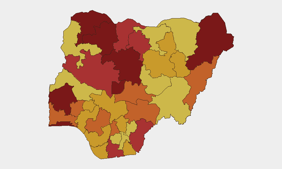
Situation Summary
Nigeria remains the second-highest-threat country globally, driven by persistent insurgency, kidnapping, and armed robbery across multiple regions. The past 48 hours have seen concentrated violent activity in Oyo State, including attacks on government facilities and abductions of civilians and minors. Institutional stress signals—including Senate demands, police-civilian friction, and intelligence service tensions—suggest governance fragility concurrent with active ground-level security deterioration. The trajectory remains volatile without indication of near-term stabilization.
Key Developments
- Ogbomoso, Oyo State (2026-06-10/11): Suspected gunmen attacked a Nigeria Immigration Service office, stealing a service rifle and injuring officers. This represents an escalation in targeting of federal security infrastructure in the state.
- Ibadan, Oyo State (2026-06-10/11): Mrs. Olaide Busayo John-Paul (sister of former Minister Adebayo Adelabu) and her 12-year-old twin sons were abducted en route to school, indicative of high-profile targeting and insider knowledge of civilian movement patterns.
- Oriire Local Government Area, Oyo State (2026-06-10/11): Civil society and labour groups staged public protests demanding release of schoolchildren and teachers abducted in the area, signaling cascading abduction activity and public mobilization.
- National-level institutional strain (2026-06-08 through 2026-06-11): Multiple signal events indicate Senate demands on the executive, Christian-community public statements, police-civilian confrontation, and Nigerian-intelligence service friction. These suggest governance stress concurrent with ground insecurity.
- Conventional military deployment (2026-06-11): Confirmed military force activity reported; specific operational scope requires clarification but indicates active response posture.
Highest-Risk Areas
Oyo State (composite risk 100) is the primary driver of current threat elevation, with a concentrated cluster of kidnappings, armed attacks on security infrastructure, and mass abductions over 48 hours. Lagos State (95.1) and Kaduna State (94.1) maintain systemic risk from urban crime, armed robbery, and banditry respectively. The ranking reflects both frequency and severity: Oyo's acute spike, combined with Lagos's persistent criminal networks and Kaduna's entrenched insurgent presence, creates compounding operational challenges for corporate security. Northern states (Katsina, Kano, Sokoto, Zamfara) remain elevated due to organized banditry and kidnapping-for-ransom operations.
How GeoBit Would Assist
Security teams should employ AOI Monitoring & Early Warning with persistent focus on Oyo, Lagos, and Kaduna to detect clustering of abduction, armed robbery, and attack activity before it affects personnel or assets. Intel Sweep combined with X/Twitter OSINT and multi-language search provides real-time signal of state-level criminal activity, gang communication, and ransom demands. GIS & Spatial Analysis with Routing & Network Analysis enables dynamic threat-informed rerouting of personnel and supply chains away from high-incidence zones. Cross-reference OSINT fusion & corroboration to validate emerging reports against official and informal sources before operational decisions.
7-Day Outlook
Oyo State activity is likely to remain elevated through mid-June absent intervention; abduction clusters often persist 5–10 days before negotiation or security response changes the dynamic. Institutional friction at the federal level may delay coordinated security response, prolonging the operational window for armed groups. Personnel and asset exposure in Oyo, Lagos, and Kaduna should be assessed and adjusted immediately.
Highest-Risk Areas — Ranked
| # | State / Region | Risk |
|---|---|---|
| 1 | Oyo State | 100 |
| 2 | Lagos State | 95.1 |
| 3 | Kaduna State | 94.1 |
| 4 | Borno State | 87.6 |
| 5 | Sokoto State | 87.1 |
| 6 | Federal Capital Territory | 86.2 |
| 7 | Zamfara State | 84.4 |
| 8 | Cross River State | 79.1 |
| 9 | Katsina State | 78.8 |
| 10 | Rivers State | 77.9 |
| 11 | Niger State | 76.3 |
| 12 | Kano State | 76 |
Sources
Previous Daily Briefs
A new Nigeria brief is written every day — each with its own risk map and downloadable CSV. Here's the last week; use the calendar to go further back.
📅 Browse every day by calendar →
Highlighted days have a brief. Tap a day for that day's map & analysis, or “csv” for that day's dataset ($5).