Situation Summary
Samoa exhibits stable security conditions as of 13 June 2026, with no verified incidents of conflict, civil unrest, major crime, or infrastructure disruption in the past 24–48 hours. The country is ranked #null globally on the composite threat index (score 7) with zero tracked events in the current window. Recent public activity—including government development-policy roadshows and cultural events—has proceeded without reported disorder or security complications.
Key Developments
- Upolu & Savai'i, Samoa – 11–12 June 2026: Government continued the public launch roadshow of the "Pathway for the Development of Samoa 2026/27–2030/31" across both islands, focused on long-term development planning with no reported security incidents or protests during either event.
- Salelologa, Savai'i, Samoa – 12 June 2026: A peaceful public gathering was held in support of the development-pathway launch; local media and government posts showed no signs of disorder, clashes, or policing action.
- Apia, Samoa – 12–13 June 2026: The cultural group PU-SIKI performed at a government-linked event in the capital, drawing large crowds with no accompanying reports of crime spikes, disruption, or public-order incidents.
- Samoa nationwide – 12–13 June 2026: Official government and ministry social-media channels posted routine governance and development announcements; no civil-unrest alerts, major-crime reports, or critical-infrastructure disruptions were issued.
- Radio Samoa – 12 June 2026: Broadcasting covered regional affairs and Samoa–Tonga relations in standard editorial fashion; no domestic emergency alerts or security warnings were broadcast.
Highest-Risk Areas
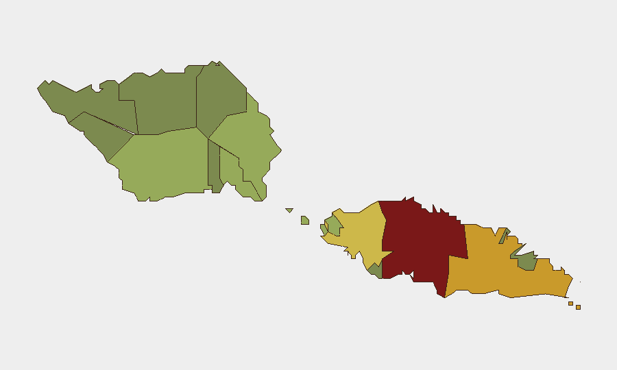
Tuamasaga (risk 85) and Ātua (risk 71) rank as the highest-risk administrative districts, likely reflecting population density, economic activity, and associated urban crime pressures in and around Apia and surrounding settlements. Aʻana (risk 62) and Aiga-i-le-Tai (risk 55) follow, suggesting secondary-urban and mixed rural–coastal risk profiles. The remaining seven districts show declining composite scores, with Vaʻa-o-Fonoti (risk 23) posing the lowest mapped risk. The dominance of Tuamasaga and Ātua in the ranking underscores the concentration of administrative, commercial, and population centers in the eastern Upolu zone; duty-of-care teams with personnel or assets in those districts should maintain standard monitoring and incident-response protocols.
How GeoBit Would Assist
Security teams operating in Samoa would benefit from AOI Monitoring & Early Warning on Tuamasaga and Ātua to detect emerging civil unrest, crime clusters, or political instability with real-time alerting. Intel Sweep and multi-language OSINT fusion across Samoan government, media, and social platforms (Facebook, X, local radio) would provide continuous corroboration of stability claims and early detection of localized incidents. Risk & Threat Assessment coupled with sentiment and temporal analysis of social and official channels would flag shifts in political mood or governance challenges before they escalate to operational risk.
7-Day Outlook
Near-term trajectory remains stable. Completion of the development-pathway roadshow and resumption of routine governance cycles over the next 7 days suggest no imminent flash-point events. Persistent monitoring of Tuamasaga and urban Ātua districts for minor crime fluctuations and civic sentiment is advisable; no elevation of alert status is warranted at present.
Highest-Risk Areas — Ranked
| # | State / Region | Risk |
|---|---|---|
| 1 | Tuamasaga | 85 |
| 2 | Ātua | 71 |
| 3 | Aʻana | 62 |
| 4 | Aiga-i-le-Tai | 55 |
| 5 | Faʻasaleleaga | 48 |
| 6 | Palauli | 42 |
| 7 | Satupaʻitea | 38 |
| 8 | Gagaʻemauga | 35 |
| 9 | Gagaʻifomauga | 32 |
| 10 | Vaisigano | 28 |
| 11 | Vaʻa-o-Fonoti | 23 |
Sources
Previous Daily Briefs
A new Samoa brief is written every day — each with its own risk map and downloadable CSV. Here's the last week; use the calendar to go further back.
📅 Browse every day by calendar →
Highlighted days have a brief. Tap a day for that day's map & analysis, or “csv” for that day's dataset ($5).