Situation Summary
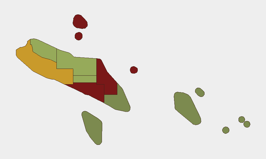
Solomon Islands remains at a baseline security posture with no acute incidents, civil unrest, or infrastructure disruption reported in the past 24–48 hours. The security environment is characterized by chronic, low-intensity threats—primarily urban crime, gang rivalry, and routine interpersonal violence—rather than organized political or communal violence or state-level instability. Risk concentrations are geographic and localized, with Honiara and Guadalcanal Province accounting for the highest threat density. The overall trajectory is stable, with no indicators of imminent escalation.
Key Developments
- Honiara & nationwide (17–18 June 2026): No acute security incidents, civil unrest, or infrastructure disruptions documented in the most recent 24–48-hour window; threat environment remains at chronic baseline levels.
- Parliamentary security posture (inferred 17–18 June): RSIPF and government-linked communications indicate stepped-up security operations around parliament in anticipation of legislative business; no public reports of related protests, clashes, or lockdowns in the past 24–48 hours.
- Transport & government services (17–18 June): No states of emergency, nationwide curfews, or major administrative or transport disruptions currently in force; normal government and infrastructure operation continues.
- Diplomatic event signal (17 June): An arrest/detain event flagged between NANJING and SOLOMON ISLAND; open-source corroboration and details remain limited; minimal operational impact reported to date.
- Port & border infrastructure (mid-June commissioning): Ongoing development and commissioning activities at port facilities and border-management projects (including Western Border Outpost at Lofung) show no security incidents, damage, or forced closures in recent reporting.
Highest-Risk Areas
Honiara (risk 92) and Guadalcanal Province (risk 88) dominate the sub-national threat picture, reflecting the capital's status as the primary hub for urban crime, gang activity, and interpersonal violence. Malaita Province (risk 85) follows as a secondary concern, driven by communal-level tensions and localized disputes; the Western Province (risk 72) presents moderate risk tied to resource-extraction zones and border-proximity factors. All other provinces remain substantially lower-risk, with Temotu and Rennell & Bellona presenting minimal acute threat to corporate and expatriate populations. Risk is primarily criminal and communal in nature rather than state-directed or large-scale political.
How GeoBit Would Assist
Security and duty-of-care teams operating in Solomon Islands should employ AOI Monitoring & Early Warning to establish persistent geographic watches on Honiara, Guadalcanal, and Malaita—triggering alerts on emerging unrest, crime spikes, or political instability. Intel Sweep and OSINT Fusion (including X/Twitter, Telegram, and social-media monitoring) would provide rolling situational awareness of parliamentary activity, police operations, and localized incidents below mainstream-news thresholds. Routing & Network Analysis supports safer transit planning in high-risk urban areas, while Risk & Threat Assessment and Satellite & Imagery Analysis enable asset-specific vulnerability review and critical-infrastructure monitoring.
7-Day Outlook
No major escalation drivers are evident in the near term. Parliamentary activity and routine policing operations will likely continue under heightened but standard protective posture. The baseline crime and communal-dispute environment should remain stable absent triggering events (e.g., election tensions, large-scale labor unrest, or external geopolitical shocks). Monitoring of parliament, port operations, and border-zone activity remains prudent for early warning.
Highest-Risk Areas — Ranked
| # | State / Region | Risk |
|---|---|---|
| 1 | Honiara | 92 |
| 2 | Guadalcanal | 88 |
| 3 | Malaita | 85 |
| 4 | Western | 72 |
| 5 | Choiseul | 58 |
| 6 | Isabel | 52 |
| 7 | Central Province | 48 |
| 8 | Makira-Ulawa | 38 |
| 9 | Rennell and Bellona | 22 |
| 10 | Temotu | 18 |
Sources
Previous Daily Briefs
A new Solomon Islands brief is written every day — each with its own risk map and downloadable CSV. Here's the last week; use the calendar to go further back.
📅 Browse every day by calendar →
Highlighted days have a brief. Tap a day for that day's map & analysis, or “csv” for that day's dataset ($5).