Situation Summary
Suriname remains a low-threat country globally (rank 174), but security risk is highly concentrated in interior and eastern regions where narcotics trafficking, illegal mining, armed robbery, and illicit airstrip activity persist. The past week saw continued enforcement operations targeting organized crime, weapons trafficking, and port security vulnerabilities, alongside isolated street violence in Paramaribo. Overall trajectory remains stable with episodic crime concentrations rather than systemic instability.
Key Developments
- 15 October — Jules Sedney Port, Paramaribo: Suriname deployed a new Port Control Unit integrating police, military police, national security, and customs personnel to strengthen port-security and border-control enforcement, reflecting concern over trafficking vulnerabilities at a critical chokepoint.
- 16 October — Nationwide: Police issued a wanted notice for Gregory R. Pinas, flagged as armed and dangerous, with allegations of robbery with violence, aggravated assault, attempted aggravated assault, and stalking; the nationwide circulation suggests significant threat profile.
- 16 October — 21 Pasi gold settlement, Brokopondo District: Police and National Army personnel arrested a suspect following discovery of an illegal revolver and ammunition magazine; consistent with interior illicit-mining-zone enforcement patterns.
- 16–17 October — Latour, Paramaribo: Following a reported fight and gunfire near Gorba nightclub at the Latourweg–Martin Luther Kingweg intersection, police arrested a 26-year-old suspect and recovered a Glock handgun with five live rounds from a Toyota Vitz; indicative of recurring armed street confrontations in urban nightlife districts.
- 16 October — Latour, Paramaribo: Police conducted a vehicle-checkpoint operation inspecting 341 vehicles and issuing 29 traffic citations, part of routine enforcement intensity in the capital's high-activity zones.
- 17 October — National internet network: A brief disruption affected the national internet control plane with connectivity subsequently restored; cause and duration remain unclear, but raises awareness of critical-infrastructure vulnerability.
Highest-Risk Areas
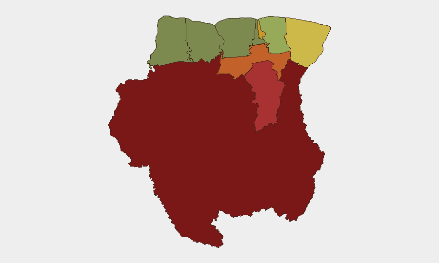
Sipaliwini district (risk 92) dominates the threat landscape as a vast, remote interior zone where illegal airstrips, narcotics transshipment, artisanal and illicit mining, and minimal state presence create a lawless environment. Brokopondo (78) and Para (74) also lie in the interior/eastern hinterland and show similar narcotics and mining-related risks. Paramaribo (71), despite being the capital and seat of authority, records high risk due to concentrated urban crime—robbery, armed assault, and weapons circulation—particularly in entertainment and commercial districts. Marowijne (68) on the eastern border reflects trafficking and cross-border smuggling pressures. Coastal and western regions (Commewijne, Wanica, Saramacca, Coronie, Nickerie) register significantly lower risk, suggesting security capacity and population density decline sharply inland.
How GeoBit Would Assist
Security teams managing personnel or assets in Suriname should use GeoBit's AOI Monitoring & Early Warning to track developments in Sipaliwini, Brokopondo, and Paramaribo districts in real-time, coupled with OSINT fusion (X/social media, news feeds, multi-language search) to detect emerging crime or trafficking signals before they affect operations. Network & Actor Analysis and entity extraction enable tracking of criminal organizations and wanted individuals circulating in police notices. For duty-of-care planning, Routing & Network Analysis supports identification of safer travel corridors and checkpoint avoidance in high-risk interior zones.
7-Day Outlook
Port-security and interior-enforcement operations are likely to continue at current tempo as Surinamese authorities respond to persistent narcotics and trafficking flows. Street violence in Paramaribo will remain sporadic and localized to entertainment and commercial districts rather than indicating systemic escalation. No major political, economic, or security shifts are anticipated over the next seven days.
Highest-Risk Areas — Ranked
| # | State / Region | Risk |
|---|---|---|
| 1 | Sipaliwini | 92 |
| 2 | Brokopondo | 78 |
| 3 | Para | 74 |
| 4 | Paramaribo | 71 |
| 5 | Marowijne | 68 |
| 6 | Commewijne | 42 |
| 7 | Wanica | 38 |
| 8 | Saramacca | 29 |
| 9 | Coronie | 12 |
| 10 | Nickerie | 8 |
Sources
Previous Weekly Briefs
A new Suriname brief is written every Monday, covering the week — each with its own risk map and downloadable CSV. Use the calendar to go further back.
- October 13, 2026
- October 6, 2026
- September 29, 2026
- September 22, 2026
- September 15, 2026
- September 8, 2026
- September 1, 2026
📅 Browse past briefs by calendar →
Highlighted days have a brief. Tap a day for that day's map & analysis, or “csv” for that day's dataset ($5).
Atlas — our AI intelligence desk — emails them this snapshot personally. Nothing else, no list.